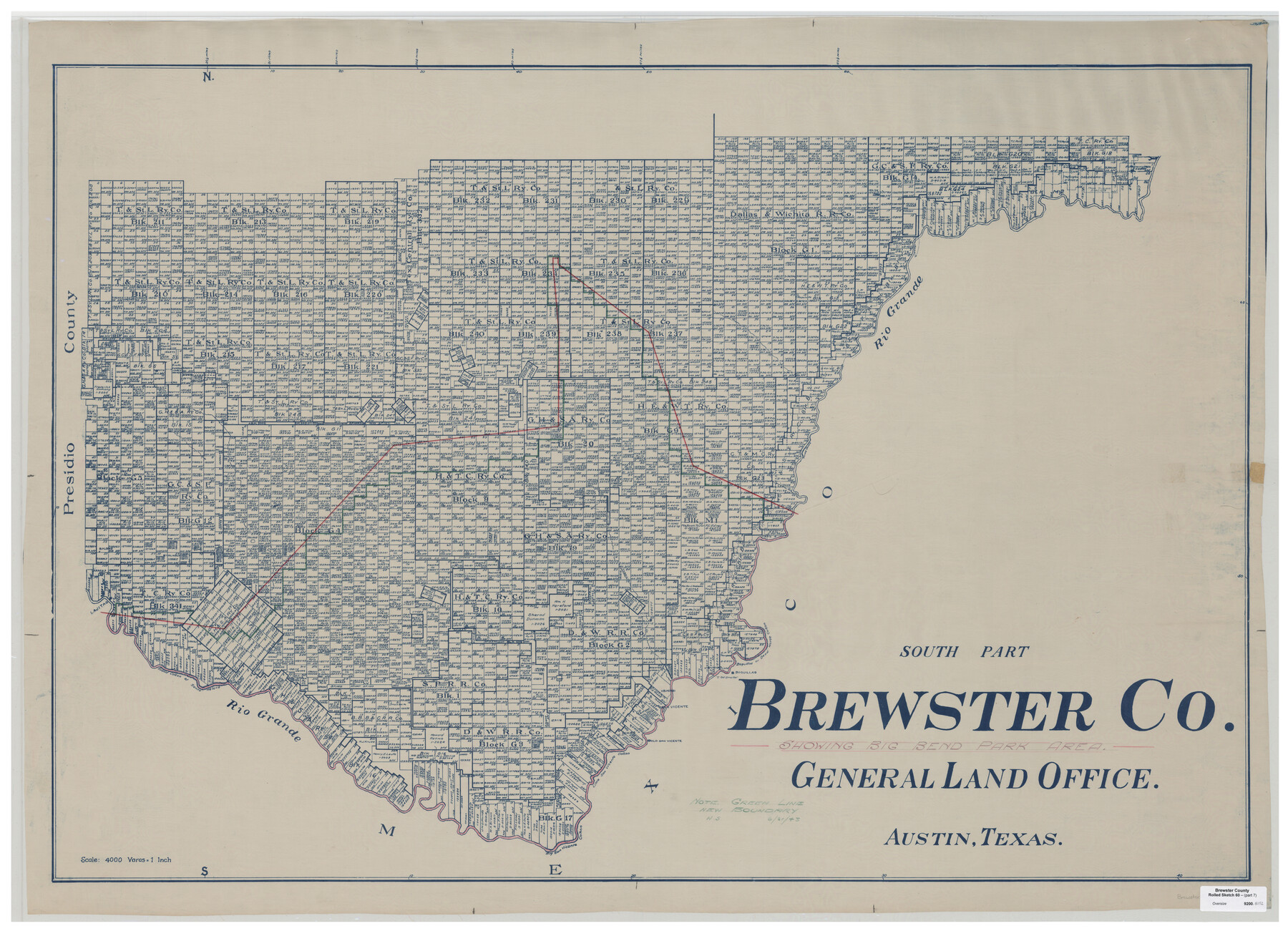
Brewster County Rolled Sketch 60
South part Brewster Co. showing Big Bend Park area
-
Map/Doc
9200
-
Collection
General Map Collection
-
Counties
Brewster
-
Subjects
Surveying Rolled Sketch
-
Height x Width
36.7 x 50.8 inches
93.2 x 129.0 cm
-
Medium
blueprint/diazo
-
Scale
1" = 4000 varas
-
Comments
See Brewster County Rolled Sketch 126 (43230) for surveyor’s report.
Related maps
Brewster County Rolled Sketch 60

Print $40.00
- Digital $50.00
Brewster County Rolled Sketch 60
Size 36.6 x 50.3 inches
Map/Doc 10692
Brewster County Sketch File 46

Print $16.00
- Digital $50.00
Brewster County Sketch File 46
1939
Size 9.3 x 6.2 inches
Map/Doc 16313
Brewster County Rolled Sketch 60

Print $40.00
- Digital $50.00
Brewster County Rolled Sketch 60
1942
Size 42.9 x 48.0 inches
Map/Doc 16960
Brewster County Rolled Sketch 126

Print $225.00
- Digital $50.00
Brewster County Rolled Sketch 126
1908
Map/Doc 43230
Brewster County Rolled Sketch 60

Print $20.00
- Digital $50.00
Brewster County Rolled Sketch 60
Size 24.8 x 36.5 inches
Map/Doc 61783
Brewster County Rolled Sketch 60

Print $40.00
- Digital $50.00
Brewster County Rolled Sketch 60
Size 53.9 x 28.0 inches
Map/Doc 61784
Brewster County Rolled Sketch 60

Print $20.00
- Digital $50.00
Brewster County Rolled Sketch 60
Size 25.0 x 37.5 inches
Map/Doc 8484
Brewster County Rolled Sketch 60

Print $40.00
- Digital $50.00
Brewster County Rolled Sketch 60
Size 37.1 x 68.9 inches
Map/Doc 8485
Part of: General Map Collection
Stonewall County Sketch File C

Print $20.00
- Digital $50.00
Stonewall County Sketch File C
1886
Size 13.1 x 8.2 inches
Map/Doc 37196
Dawson County Sketch File 16

Print $14.00
- Digital $50.00
Dawson County Sketch File 16
Size 13.4 x 8.8 inches
Map/Doc 20551
Kimble County Working Sketch 86

Print $20.00
- Digital $50.00
Kimble County Working Sketch 86
1973
Size 39.3 x 25.6 inches
Map/Doc 70154
Overlay For BRE-1P, Frame 153 of Refugio Scrip 1930, Nueces County

Print $20.00
- Digital $50.00
Overlay For BRE-1P, Frame 153 of Refugio Scrip 1930, Nueces County
1956
Size 18.8 x 22.6 inches
Map/Doc 86713
Angelina County Working Sketch 39

Print $20.00
- Digital $50.00
Angelina County Working Sketch 39
1959
Size 25.6 x 30.0 inches
Map/Doc 67122
Harris County Working Sketch 91

Print $20.00
- Digital $50.00
Harris County Working Sketch 91
1973
Size 44.6 x 36.9 inches
Map/Doc 65983
Schleicher County Working Sketch 10

Print $20.00
- Digital $50.00
Schleicher County Working Sketch 10
1923
Size 18.3 x 16.4 inches
Map/Doc 63812
King County Sketch File 12

Print $10.00
- Digital $50.00
King County Sketch File 12
1903
Size 11.3 x 8.6 inches
Map/Doc 29105
Nueces County Rolled Sketch 71

Print $247.00
Nueces County Rolled Sketch 71
1980
Size 37.9 x 24.7 inches
Map/Doc 6924
Culberson County Sketch File 43

Print $4.00
- Digital $50.00
Culberson County Sketch File 43
1931
Size 8.9 x 11.1 inches
Map/Doc 20329
Ellis County Working Sketch 1

Print $20.00
- Digital $50.00
Ellis County Working Sketch 1
1939
Size 19.1 x 19.3 inches
Map/Doc 69017
Flight Mission No. DIX-6P, Frame 188, Aransas County

Print $20.00
- Digital $50.00
Flight Mission No. DIX-6P, Frame 188, Aransas County
1956
Size 19.0 x 22.9 inches
Map/Doc 83850
You may also like
Map of Brown County

Print $20.00
- Digital $50.00
Map of Brown County
1858
Size 25.7 x 25.3 inches
Map/Doc 3336
Taylor County Working Sketch 5

Print $20.00
- Digital $50.00
Taylor County Working Sketch 5
1950
Size 31.1 x 24.7 inches
Map/Doc 69615
Ellis County Working Sketch 1
Print $20.00
- Digital $50.00
Ellis County Working Sketch 1
1939
Size 19.1 x 19.3 inches
Map/Doc 69017
Jeff Davis County Working Sketch 10

Print $20.00
- Digital $50.00
Jeff Davis County Working Sketch 10
1946
Size 29.3 x 37.0 inches
Map/Doc 66505
Galveston County Sketch File 34

Print $20.00
- Digital $50.00
Galveston County Sketch File 34
1934
Size 11.5 x 20.1 inches
Map/Doc 11536
Brazoria County Sketch File 3

Print $46.00
- Digital $50.00
Brazoria County Sketch File 3
Size 13.1 x 9.4 inches
Map/Doc 14923
Uvalde County Working Sketch 44

Print $20.00
- Digital $50.00
Uvalde County Working Sketch 44
1978
Size 27.6 x 32.7 inches
Map/Doc 72114
[Gulf Colorado & Santa Fe from 2178+36.0 to 3901+06.2]
![64698, [Gulf Colorado & Santa Fe from 2178+36.0 to 3901+06.2], General Map Collection](https://historictexasmaps.com/wmedia_w700/maps/64698.tif.jpg)
Print $40.00
- Digital $50.00
[Gulf Colorado & Santa Fe from 2178+36.0 to 3901+06.2]
Size 123.0 x 32.2 inches
Map/Doc 64698
Flight Mission No. DQN-6K, Frame 16, Calhoun County

Print $20.00
- Digital $50.00
Flight Mission No. DQN-6K, Frame 16, Calhoun County
1953
Size 18.7 x 22.2 inches
Map/Doc 84438
General Highway Map, Eastland County, Texas

Print $20.00
General Highway Map, Eastland County, Texas
1961
Size 18.2 x 24.7 inches
Map/Doc 79450

Hardin County Working Sketch 17

Print $20.00
- Digital $50.00
Hardin County Working Sketch 17
1942
Size 18.4 x 12.6 inches
Map/Doc 63415