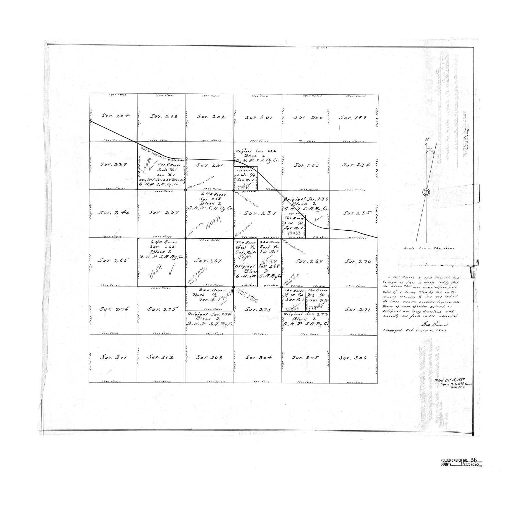
Presidio County Rolled Sketch BB
[Sketch of surveys in Block 2, G. H. & S. A. Ry. Co.]
-
Map/Doc
7407
-
Collection
General Map Collection
-
Object Dates
1937/10/8 (Creation Date)
1937/10/15 (File Date)
-
People and Organizations
Bill Burson (Surveyor/Engineer)
-
Counties
Presidio
-
Subjects
Surveying Rolled Sketch
-
Height x Width
26.3 x 27.1 inches
66.8 x 68.8 cm
-
Scale
1" = 760 varas
Part of: General Map Collection
Flight Mission No. CUG-1P, Frame 110, Kleberg County

Print $20.00
- Digital $50.00
Flight Mission No. CUG-1P, Frame 110, Kleberg County
1956
Size 18.5 x 22.2 inches
Map/Doc 86160
Webb County Rolled Sketch 79

Print $20.00
- Digital $50.00
Webb County Rolled Sketch 79
2020
Size 35.7 x 24.9 inches
Map/Doc 95916
Travis County Sketch File 43

Print $30.00
- Digital $50.00
Travis County Sketch File 43
1887
Size 8.8 x 9.3 inches
Map/Doc 38359
Upton County Rolled Sketch 39

Print $40.00
- Digital $50.00
Upton County Rolled Sketch 39
Size 53.4 x 44.1 inches
Map/Doc 10055
Hardeman County Working Sketch 4

Print $40.00
- Digital $50.00
Hardeman County Working Sketch 4
1920
Size 23.9 x 70.2 inches
Map/Doc 63385
Williamson County Sketch File 27

Print $12.00
- Digital $50.00
Williamson County Sketch File 27
1940
Size 14.3 x 8.7 inches
Map/Doc 40371
Hansford County Rolled Sketch 1

Print $20.00
- Digital $50.00
Hansford County Rolled Sketch 1
1979
Size 22.3 x 17.6 inches
Map/Doc 6064

El Paso County Sketch File 10

Print $52.00
- Digital $50.00
El Paso County Sketch File 10
1890
Size 8.4 x 5.4 inches
Map/Doc 21974
Irion County Rolled Sketch 3

Print $20.00
- Digital $50.00
Irion County Rolled Sketch 3
Size 26.2 x 27.5 inches
Map/Doc 6318
Upton County Boundary File 2

Print $6.00
- Digital $50.00
Upton County Boundary File 2
Size 14.4 x 8.9 inches
Map/Doc 59517
Kleberg County Rolled Sketch 10-23

Print $20.00
- Digital $50.00
Kleberg County Rolled Sketch 10-23
1953
Size 37.5 x 31.3 inches
Map/Doc 9396
You may also like
Edwards County Sketch File A

Print $20.00
- Digital $50.00
Edwards County Sketch File A
Size 25.3 x 35.5 inches
Map/Doc 11448
Flight Mission No. DIX-10P, Frame 66, Aransas County

Print $20.00
- Digital $50.00
Flight Mission No. DIX-10P, Frame 66, Aransas County
1956
Size 18.8 x 22.5 inches
Map/Doc 83927
Cherokee County Sketch File 3

Print $4.00
- Digital $50.00
Cherokee County Sketch File 3
1849
Size 7.5 x 11.0 inches
Map/Doc 18115
San Patricio County Rolled Sketch 55

Print $20.00
- Digital $50.00
San Patricio County Rolled Sketch 55
1999
Size 25.1 x 36.7 inches
Map/Doc 7741
Sabine County Working Sketch 15

Print $20.00
- Digital $50.00
Sabine County Working Sketch 15
1957
Size 21.2 x 34.9 inches
Map/Doc 63686
Navigation Maps of Gulf Intracoastal Waterway, Port Arthur to Brownsville, Texas

Print $4.00
- Digital $50.00
Navigation Maps of Gulf Intracoastal Waterway, Port Arthur to Brownsville, Texas
1951
Size 16.8 x 21.6 inches
Map/Doc 65419
Harris County Working Sketch 120

Print $20.00
- Digital $50.00
Harris County Working Sketch 120
1985
Size 29.3 x 14.6 inches
Map/Doc 66012
Flight Mission No. DAG-21K, Frame 123, Matagorda County

Print $20.00
- Digital $50.00
Flight Mission No. DAG-21K, Frame 123, Matagorda County
1952
Size 18.5 x 22.4 inches
Map/Doc 86449
Stephens County Sketch File 10b

Print $8.00
- Digital $50.00
Stephens County Sketch File 10b
1890
Size 8.5 x 7.8 inches
Map/Doc 37048
[W. T. Brewer: M. McDonald, Ralph Gilpin, A. Vanhooser, John Baker, John R. Taylor Surveys]
![90964, [W. T. Brewer: M. McDonald, Ralph Gilpin, A. Vanhooser, John Baker, John R. Taylor Surveys], Twichell Survey Records](https://historictexasmaps.com/wmedia_w700/maps/90964-1.tif.jpg)
Print $2.00
- Digital $50.00
[W. T. Brewer: M. McDonald, Ralph Gilpin, A. Vanhooser, John Baker, John R. Taylor Surveys]
Size 8.8 x 11.3 inches
Map/Doc 90964
T. L. Morris Farm Rt. 6

Print $20.00
- Digital $50.00
T. L. Morris Farm Rt. 6
Size 16.3 x 13.2 inches
Map/Doc 92341
Reagan County Working Sketch 17

Print $20.00
- Digital $50.00
Reagan County Working Sketch 17
1954
Size 21.0 x 11.7 inches
Map/Doc 71859