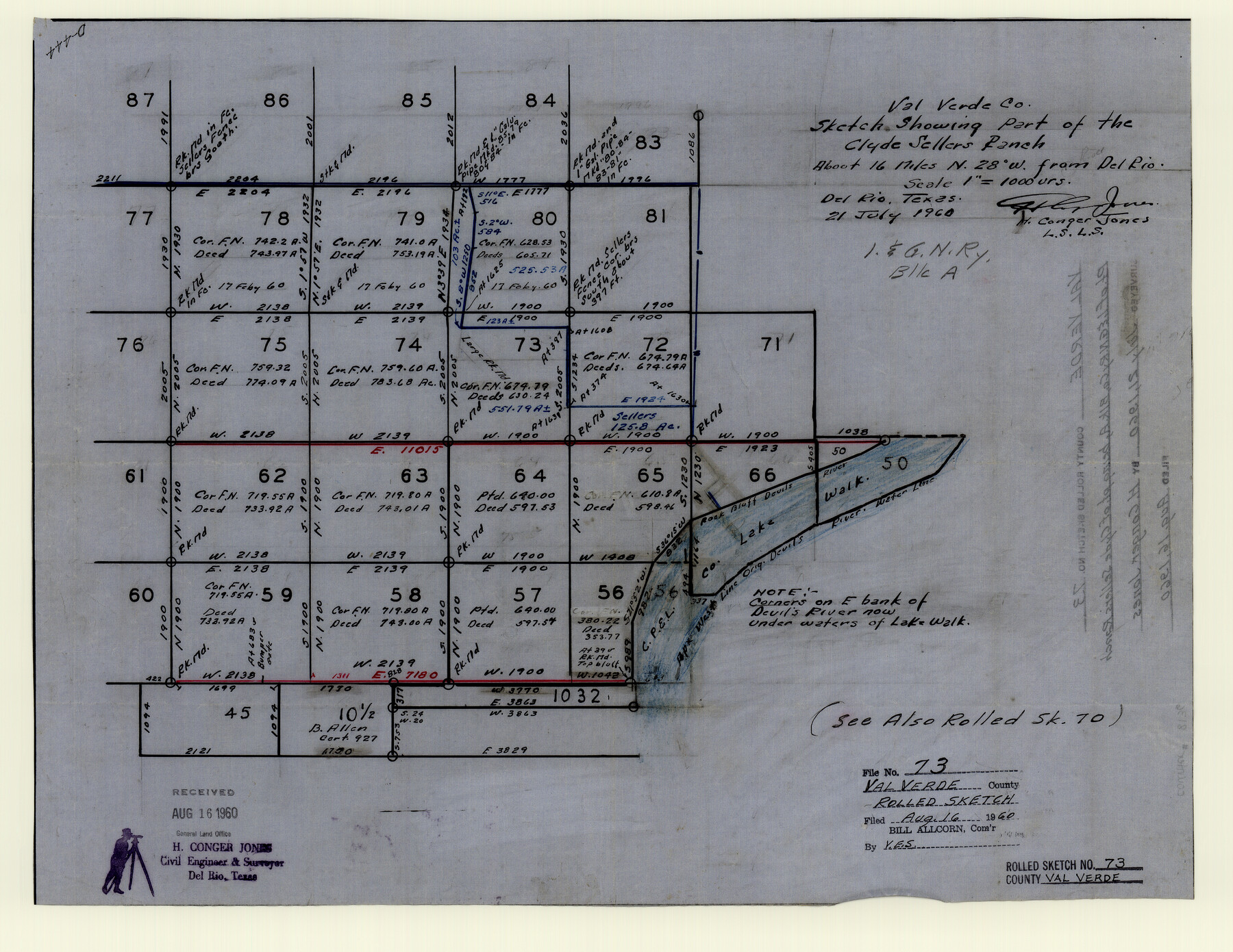
Val Verde County Rolled Sketch 73
Val Verde Co. sketch showing part of the Clyde Sellers Ranch
-
Map/Doc
8136
-
Collection
General Map Collection
-
Object Dates
1960/7/21 (Creation Date)
1960/8/16 (File Date)
-
People and Organizations
H. Conger Jones (Surveyor/Engineer)
-
Counties
Val Verde
-
Subjects
Surveying Rolled Sketch
-
Height x Width
15.0 x 19.4 inches
38.1 x 49.3 cm
-
Medium
linen, manuscript
-
Scale
1" = 1000 varas
Part of: General Map Collection
Flight Mission No. DAH-9M, Frame 85, Orange County

Print $20.00
- Digital $50.00
Flight Mission No. DAH-9M, Frame 85, Orange County
1953
Size 18.5 x 22.7 inches
Map/Doc 86849
[Surveys in Austin's Colony along Buffalo Bayou and the San Jacinto River]
![51, [Surveys in Austin's Colony along Buffalo Bayou and the San Jacinto River], General Map Collection](https://historictexasmaps.com/wmedia_w700/maps/51.tif.jpg)
Print $20.00
- Digital $50.00
[Surveys in Austin's Colony along Buffalo Bayou and the San Jacinto River]
1824
Size 23.7 x 17.6 inches
Map/Doc 51
Comanche County Working Sketch 5

Print $20.00
- Digital $50.00
Comanche County Working Sketch 5
1919
Size 31.8 x 28.9 inches
Map/Doc 68139
Jasper County Working Sketch 4

Print $20.00
- Digital $50.00
Jasper County Working Sketch 4
1905
Size 20.3 x 13.5 inches
Map/Doc 66466
Hardin County Sketch File Q-11

Print $20.00
- Digital $50.00
Hardin County Sketch File Q-11
1937
Size 19.9 x 23.8 inches
Map/Doc 11645
Jasper County Sketch File 10

Print $4.00
- Digital $50.00
Jasper County Sketch File 10
1878
Size 9.1 x 8.6 inches
Map/Doc 27788

Williamson County Sketch File 18

Print $6.00
- Digital $50.00
Williamson County Sketch File 18
1871
Size 12.8 x 8.1 inches
Map/Doc 40342
Flight Mission No. DIX-8P, Frame 92, Aransas County

Print $20.00
- Digital $50.00
Flight Mission No. DIX-8P, Frame 92, Aransas County
1956
Size 18.5 x 22.3 inches
Map/Doc 83917
Hood County Sketch File 8

Print $4.00
- Digital $50.00
Hood County Sketch File 8
Size 7.8 x 8.0 inches
Map/Doc 26584
Flight Mission No. CUG-1P, Frame 50, Kleberg County

Print $20.00
- Digital $50.00
Flight Mission No. CUG-1P, Frame 50, Kleberg County
1956
Size 18.6 x 22.3 inches
Map/Doc 86128
[Surveys in the Bexar District along the Guadalupe River]
![124, [Surveys in the Bexar District along the Guadalupe River], General Map Collection](https://historictexasmaps.com/wmedia_w700/maps/124.tif.jpg)
Print $3.00
- Digital $50.00
[Surveys in the Bexar District along the Guadalupe River]
1841
Size 17.2 x 10.8 inches
Map/Doc 124
You may also like
Pecos County Rolled Sketch 41

Print $20.00
- Digital $50.00
Pecos County Rolled Sketch 41
Size 22.7 x 31.3 inches
Map/Doc 7219
Comal County Sketch File 13

Print $8.00
- Digital $50.00
Comal County Sketch File 13
1866
Size 9.5 x 14.9 inches
Map/Doc 19026
San Jacinto County Working Sketch 36

Print $40.00
- Digital $50.00
San Jacinto County Working Sketch 36
1964
Size 33.0 x 57.2 inches
Map/Doc 63749

Mason County Sketch File 5

Print $20.00
- Digital $50.00
Mason County Sketch File 5
1875
Size 15.8 x 12.9 inches
Map/Doc 12033
[River Secs. 55-79, Archer County School Land League 3 and surrounding surveys]
![90472, [River Secs. 55-79, Archer County School Land League 3 and surrounding surveys], Twichell Survey Records](https://historictexasmaps.com/wmedia_w700/maps/90472-1.tif.jpg)
Print $20.00
- Digital $50.00
[River Secs. 55-79, Archer County School Land League 3 and surrounding surveys]
Size 28.3 x 20.4 inches
Map/Doc 90472
Cooke County Working Sketch 25

Print $20.00
- Digital $50.00
Cooke County Working Sketch 25
1974
Size 31.7 x 22.9 inches
Map/Doc 68262
Rand McNally Standard Map of Texas

Print $20.00
Rand McNally Standard Map of Texas
1923
Size 27.7 x 40.3 inches
Map/Doc 76259
Leon County Rolled Sketch 26A

Print $20.00
- Digital $50.00
Leon County Rolled Sketch 26A
1988
Size 21.5 x 34.4 inches
Map/Doc 6611
Upton County Sketch File 36

Print $14.00
- Digital $50.00
Upton County Sketch File 36
1952
Size 11.3 x 8.8 inches
Map/Doc 38893
Map of East Part of Pecos Co.

Print $20.00
- Digital $50.00
Map of East Part of Pecos Co.
1896
Size 47.4 x 37.6 inches
Map/Doc 66975
[Sketch showing correct location of the North and East lines of the Nave McCord pasture fence]
![90896, [Sketch showing correct location of the North and East lines of the Nave McCord pasture fence], Twichell Survey Records](https://historictexasmaps.com/wmedia_w700/maps/90896-1.tif.jpg)
Print $20.00
- Digital $50.00
[Sketch showing correct location of the North and East lines of the Nave McCord pasture fence]
1900
Size 20.3 x 11.8 inches
Map/Doc 90896