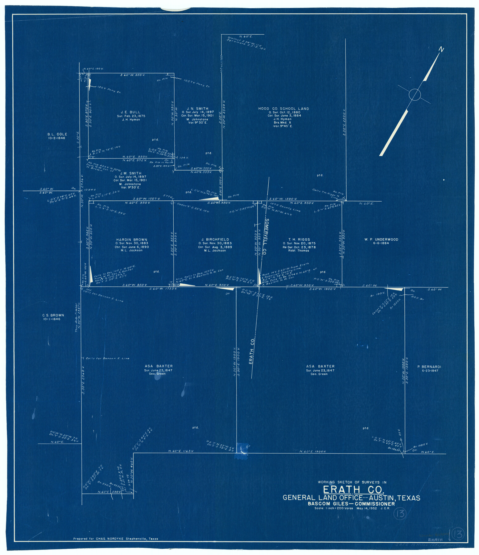
Erath County Working Sketch 13
-
Map/Doc
69094
-
Collection
General Map Collection
-
Object Dates
5/14/1952 (Creation Date)
-
Counties
Erath
-
Subjects
Surveying Working Sketch
-
Height x Width
31.4 x 27.1 inches
79.8 x 68.8 cm
-
Scale
1" = 200 varas
Part of: General Map Collection
Upton County Rolled Sketch 35

Print $20.00
- Digital $50.00
Upton County Rolled Sketch 35
1951
Size 37.3 x 19.2 inches
Map/Doc 8077
Brooks County Sketch File 3

Print $40.00
- Digital $50.00
Brooks County Sketch File 3
Size 21.5 x 19.0 inches
Map/Doc 11016
[Bastrop District]
![83005, [Bastrop District], General Map Collection](https://historictexasmaps.com/wmedia_w700/maps/83005.tif.jpg)
Print $40.00
- Digital $50.00
[Bastrop District]
1895
Size 37.4 x 51.9 inches
Map/Doc 83005
Harris County Working Sketch 8

Print $20.00
- Digital $50.00
Harris County Working Sketch 8
1904
Size 26.8 x 23.3 inches
Map/Doc 65900
Jack County Working Sketch Graphic Index

Print $20.00
- Digital $50.00
Jack County Working Sketch Graphic Index
1925
Size 45.4 x 37.3 inches
Map/Doc 76589
Bell County Boundary File 3

Print $24.00
- Digital $50.00
Bell County Boundary File 3
Size 11.1 x 8.6 inches
Map/Doc 50490
Aransas County Rolled Sketch 12

Print $20.00
- Digital $50.00
Aransas County Rolled Sketch 12
Size 17.6 x 11.1 inches
Map/Doc 77191
Burnet County Rolled Sketch T

Print $20.00
- Digital $50.00
Burnet County Rolled Sketch T
Size 24.9 x 18.5 inches
Map/Doc 76053
Live Oak County

Print $20.00
- Digital $50.00
Live Oak County
1879
Size 27.3 x 21.5 inches
Map/Doc 3821
El Paso County Rolled Sketch 64

Print $246.00
- Digital $50.00
El Paso County Rolled Sketch 64
1993
Size 11.3 x 8.7 inches
Map/Doc 41531
Dimmit County Sketch File 13

Print $46.00
- Digital $50.00
Dimmit County Sketch File 13
1884
Size 22.6 x 36.5 inches
Map/Doc 11341
Presidio County Rolled Sketch 1

Print $20.00
- Digital $50.00
Presidio County Rolled Sketch 1
Size 24.5 x 15.7 inches
Map/Doc 7325
You may also like
Cass County Sketch File 2

Print $4.00
- Digital $50.00
Cass County Sketch File 2
1849
Size 12.4 x 7.7 inches
Map/Doc 17394
Eastland County Sketch File 6

Print $4.00
- Digital $50.00
Eastland County Sketch File 6
1871
Size 8.3 x 12.8 inches
Map/Doc 21572
Flight Mission No. BRA-16M, Frame 64, Jefferson County

Print $20.00
- Digital $50.00
Flight Mission No. BRA-16M, Frame 64, Jefferson County
1953
Size 18.8 x 22.3 inches
Map/Doc 85681
Shelby County Sketch File 30

Print $4.00
- Digital $50.00
Shelby County Sketch File 30
1927
Size 14.3 x 8.8 inches
Map/Doc 36668
Flight Mission No. DCL-7C, Frame 67, Kenedy County

Print $20.00
- Digital $50.00
Flight Mission No. DCL-7C, Frame 67, Kenedy County
1943
Size 15.5 x 15.3 inches
Map/Doc 86053
Marion County Sketch File 9

Print $4.00
- Digital $50.00
Marion County Sketch File 9
Size 9.4 x 7.8 inches
Map/Doc 30577
Texas, Brazos River, Freeport

Print $40.00
- Digital $50.00
Texas, Brazos River, Freeport
1933
Size 28.4 x 48.3 inches
Map/Doc 69994
Block 32, Township 4 North

Print $20.00
- Digital $50.00
Block 32, Township 4 North
Size 17.5 x 25.3 inches
Map/Doc 92507
Flight Mission No. CUG-1P, Frame 169, Kleberg County

Print $20.00
- Digital $50.00
Flight Mission No. CUG-1P, Frame 169, Kleberg County
1956
Size 18.6 x 22.4 inches
Map/Doc 86176
Reeves County Sketch File 28

Print $12.00
- Digital $50.00
Reeves County Sketch File 28
2003
Size 14.3 x 8.8 inches
Map/Doc 78496
Brewster County Rolled Sketch 107

Print $20.00
- Digital $50.00
Brewster County Rolled Sketch 107
Size 22.2 x 11.2 inches
Map/Doc 5259
Map of Castro County

Print $20.00
- Digital $50.00
Map of Castro County
1900
Size 41.9 x 34.4 inches
Map/Doc 4748