Callahan County Sketch File 15
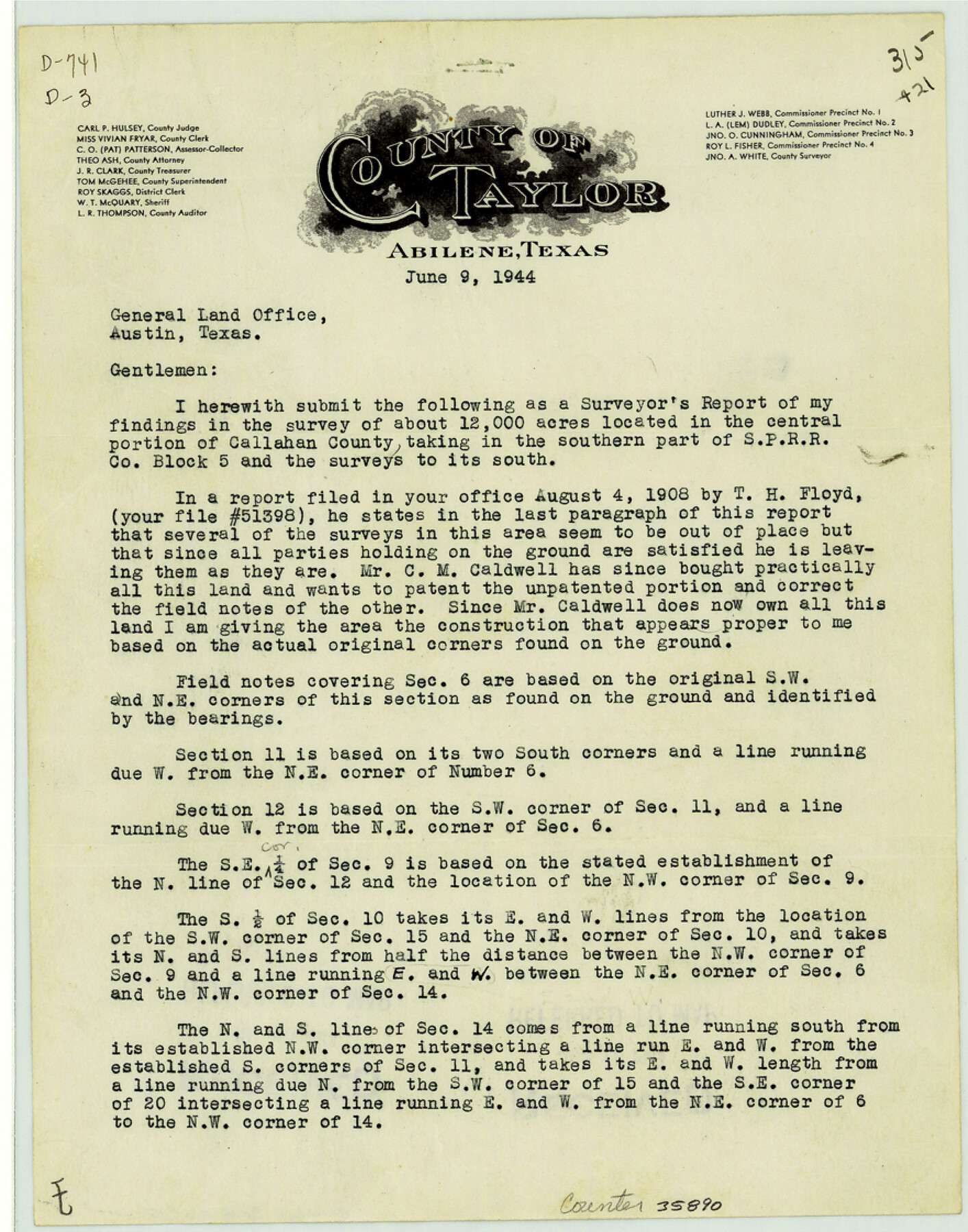
[Surveyor's report of findings of the survey of about 12000 acres located in the central part of the county taking in the southern part of S. P. R.R. Co. Block 5 and surveys to the south]
-
Map/Doc
35890
-
Collection
General Map Collection
-
Object Dates
1944/6/9 (Creation Date)
1944/7/18 (File Date)
-
People and Organizations
John A. White (Surveyor/Engineer)
-
Counties
Callahan
-
Subjects
Surveying Sketch File
-
Height x Width
11.2 x 8.8 inches
28.4 x 22.4 cm
-
Medium
paper, print
-
Comments
See Callahan County Rolled Sketch 1 (5379) for sketch.
Related maps
Callahan County Rolled Sketch 1

Print $20.00
- Digital $50.00
Callahan County Rolled Sketch 1
1944
Size 26.9 x 26.3 inches
Map/Doc 5379
Part of: General Map Collection
Hardin County Rolled Sketch 15

Print $20.00
- Digital $50.00
Hardin County Rolled Sketch 15
1938
Size 30.9 x 23.7 inches
Map/Doc 6084
Falls County Sketch File 33

Print $4.00
- Digital $50.00
Falls County Sketch File 33
1873
Size 10.3 x 8.3 inches
Map/Doc 22441
Brewster County Rolled Sketch 99

Print $20.00
- Digital $50.00
Brewster County Rolled Sketch 99
1953
Size 26.6 x 22.4 inches
Map/Doc 5255
Tarrant County Working Sketch 24

Print $20.00
- Digital $50.00
Tarrant County Working Sketch 24
2003
Size 26.0 x 34.9 inches
Map/Doc 78642
Brazoria County Rolled Sketch 41

Print $20.00
- Digital $50.00
Brazoria County Rolled Sketch 41
Size 30.3 x 21.3 inches
Map/Doc 5176
Leon County Rolled Sketch 14A

Print $200.00
- Digital $50.00
Leon County Rolled Sketch 14A
1975
Size 16.5 x 35.5 inches
Map/Doc 46535
Calhoun County Sketch File 15

Print $40.00
- Digital $50.00
Calhoun County Sketch File 15
1929
Size 36.8 x 25.4 inches
Map/Doc 11036
Wood County Sketch File 10

Print $12.00
- Digital $50.00
Wood County Sketch File 10
1850
Size 8.3 x 12.8 inches
Map/Doc 40658
Lavaca County Working Sketch 25

Print $20.00
- Digital $50.00
Lavaca County Working Sketch 25
1986
Size 33.3 x 29.9 inches
Map/Doc 70378
Map of the Lands Surveyed by the Memphis, El Paso & Pacific R.R. Company

Print $20.00
- Digital $50.00
Map of the Lands Surveyed by the Memphis, El Paso & Pacific R.R. Company
1860
Size 16.7 x 24.7 inches
Map/Doc 4845
Maverick County Sketch File 16

Print $20.00
- Digital $50.00
Maverick County Sketch File 16
1887
Size 14.1 x 34.5 inches
Map/Doc 12051
Marion County Rolled Sketch 10

Print $20.00
- Digital $50.00
Marion County Rolled Sketch 10
2023
Size 24.1 x 36.9 inches
Map/Doc 97192
You may also like
El Paso County Boundary File 20

Print $9.00
- Digital $50.00
El Paso County Boundary File 20
Size 13.2 x 8.3 inches
Map/Doc 53210
[Sketch along Garza-Kent County Line]
![89920, [Sketch along Garza-Kent County Line], Twichell Survey Records](https://historictexasmaps.com/wmedia_w700/maps/89920-1.tif.jpg)
Print $20.00
- Digital $50.00
[Sketch along Garza-Kent County Line]
Size 41.5 x 43.7 inches
Map/Doc 89920
Pecos County Rolled Sketch 65

Print $20.00
- Digital $50.00
Pecos County Rolled Sketch 65
1928
Size 37.9 x 33.8 inches
Map/Doc 9699
El Paso County Sketch File 34

Print $82.00
- Digital $50.00
El Paso County Sketch File 34
1984
Size 14.3 x 8.9 inches
Map/Doc 22129
Comanche County, Texas

Print $20.00
- Digital $50.00
Comanche County, Texas
1879
Size 23.5 x 28.4 inches
Map/Doc 702
San Augustine County Sketch File 13a

Print $4.00
San Augustine County Sketch File 13a
1879
Size 8.9 x 14.5 inches
Map/Doc 35660
Hemphill County Sketch File 10

Print $6.00
- Digital $50.00
Hemphill County Sketch File 10
1903
Size 14.3 x 8.8 inches
Map/Doc 26315
Flight Mission No. DQN-2K, Frame 2, Calhoun County

Print $20.00
- Digital $50.00
Flight Mission No. DQN-2K, Frame 2, Calhoun County
1953
Size 18.6 x 22.3 inches
Map/Doc 84219
Acreage in Texas by Counties

Acreage in Texas by Counties
1983
Size 10.3 x 11.8 inches
Map/Doc 97033

Perspective Map of the City of Laredo, Texas, the Gateway to and from Mexico

Print $20.00
Perspective Map of the City of Laredo, Texas, the Gateway to and from Mexico
1892
Size 22.1 x 34.2 inches
Map/Doc 89098
Harris County Sketch File 62

Print $14.00
- Digital $50.00
Harris County Sketch File 62
1930
Size 11.4 x 8.7 inches
Map/Doc 25486