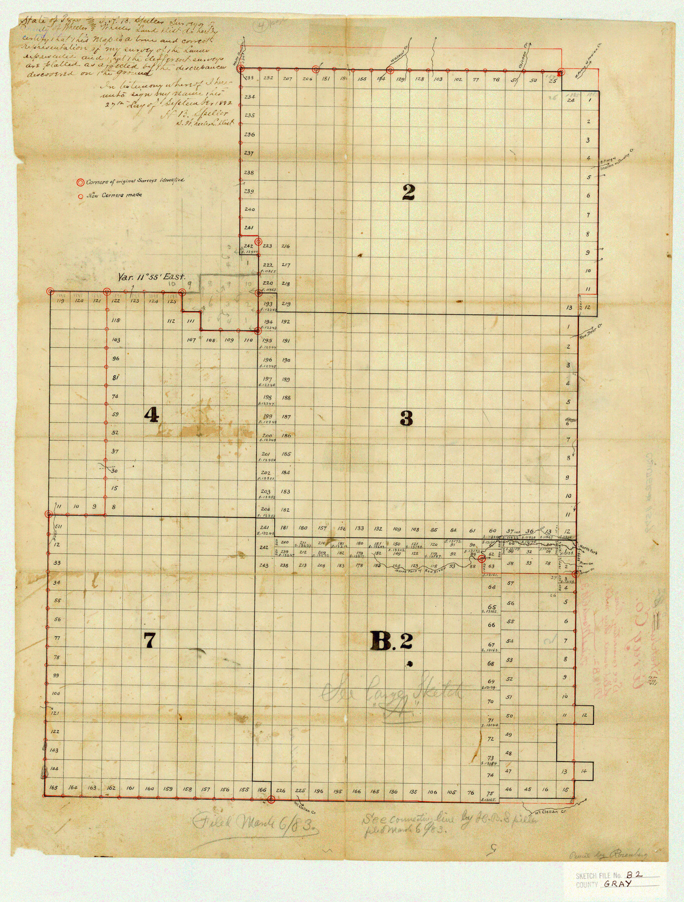
Gray County Sketch File B2
[Sketch showing Blocks 2, 3, 4, 7, and B2 spanning multiple counties]
-
Map/Doc
11579
-
Collection
General Map Collection
-
Object Dates
3/6/1883 (File Date)
-
People and Organizations
H.B. Spiller (Surveyor/Engineer)
-
Counties
Gray Roberts Carson Hutchinson
-
Subjects
Surveying Sketch File
-
Height x Width
22.8 x 17.3 inches
57.9 x 43.9 cm
-
Medium
paper, manuscript
-
Features
White Deer Creek
Walnut Creek
Chicken Creek
West Prong of Indian Creek
Dudley Creek
Red Deer Creek
Bear Creek
North Fork of Red River
Plum Creek
Grape Creek
McClellan Creek
Part of: General Map Collection
Kimble County Sketch File 41

Print $10.00
- Digital $50.00
Kimble County Sketch File 41
1994
Size 11.2 x 8.7 inches
Map/Doc 29010
Presidio County Working Sketch Graphic Index, South Part, Sheet 2 (Sketches 45 to Most Recent)

Print $20.00
- Digital $50.00
Presidio County Working Sketch Graphic Index, South Part, Sheet 2 (Sketches 45 to Most Recent)
1975
Size 32.4 x 37.9 inches
Map/Doc 76671
Hardin County Sketch File 5a

Print $6.00
- Digital $50.00
Hardin County Sketch File 5a
Size 8.1 x 3.5 inches
Map/Doc 25094
Trinity River, Clear Lake Sheet/East Fork of Trinity River and Pilot Grove Creek

Print $6.00
- Digital $50.00
Trinity River, Clear Lake Sheet/East Fork of Trinity River and Pilot Grove Creek
1923
Size 33.0 x 31.1 inches
Map/Doc 65194
Colorado River, Danevang Sheet

Print $6.00
- Digital $50.00
Colorado River, Danevang Sheet
1940
Size 24.6 x 35.2 inches
Map/Doc 65321
Mitchell County

Print $20.00
- Digital $50.00
Mitchell County
1922
Size 43.4 x 38.2 inches
Map/Doc 66936

Brewster County Rolled Sketch 94

Print $40.00
- Digital $50.00
Brewster County Rolled Sketch 94
1941
Size 26.8 x 58.6 inches
Map/Doc 8507
Rains County Sketch File 8

Print $4.00
- Digital $50.00
Rains County Sketch File 8
1872
Size 7.6 x 8.1 inches
Map/Doc 34958
Garza County Sketch File 6

Print $8.00
- Digital $50.00
Garza County Sketch File 6
1900
Size 14.2 x 8.7 inches
Map/Doc 24056
Hudspeth County Sketch File 38

Print $20.00
- Digital $50.00
Hudspeth County Sketch File 38
Size 27.5 x 24.1 inches
Map/Doc 11806
Presidio County Sketch File 52

Print $10.00
- Digital $50.00
Presidio County Sketch File 52
1921
Size 11.5 x 8.8 inches
Map/Doc 34605
You may also like
Gulf Oil Corp. Fishgide - Port O'Connor

Gulf Oil Corp. Fishgide - Port O'Connor
1960
Size 12.2 x 22.3 inches
Map/Doc 75983
Flight Mission No. DAH-10M, Frame 40, Orange County

Print $20.00
- Digital $50.00
Flight Mission No. DAH-10M, Frame 40, Orange County
1953
Size 18.8 x 22.6 inches
Map/Doc 86875
Flight Mission No. DQO-7K, Frame 78, Galveston County

Print $20.00
- Digital $50.00
Flight Mission No. DQO-7K, Frame 78, Galveston County
1952
Size 18.8 x 22.4 inches
Map/Doc 85105
Genl. Austins Map of Texas With Parts of the Adjoining States

Print $20.00
- Digital $50.00
Genl. Austins Map of Texas With Parts of the Adjoining States
1840
Size 28.5 x 23.4 inches
Map/Doc 2116
Harris County Working Sketch 23

Print $20.00
- Digital $50.00
Harris County Working Sketch 23
1926
Size 14.0 x 20.0 inches
Map/Doc 65915
Bexar County Sketch File 41

Print $4.00
- Digital $50.00
Bexar County Sketch File 41
Size 8.3 x 5.3 inches
Map/Doc 14516
San Saba County Rolled Sketch 3

Print $20.00
- Digital $50.00
San Saba County Rolled Sketch 3
Size 31.9 x 43.3 inches
Map/Doc 7744
Plat of survey in the North West portion of the Ramsey State Farm

Print $20.00
- Digital $50.00
Plat of survey in the North West portion of the Ramsey State Farm
1942
Size 25.9 x 30.4 inches
Map/Doc 94282
Edwards County Sketch File 2 and 3

Print $8.00
- Digital $50.00
Edwards County Sketch File 2 and 3
1874
Size 9.3 x 4.1 inches
Map/Doc 21676
Hamilton County Rolled Sketch 8

Print $20.00
- Digital $50.00
Hamilton County Rolled Sketch 8
1943
Size 28.0 x 32.8 inches
Map/Doc 6058
Tech Terrace an Addition to The City of Lubbock

Print $20.00
- Digital $50.00
Tech Terrace an Addition to The City of Lubbock
1946
Size 24.7 x 15.3 inches
Map/Doc 92712
Stonewall County Working Sketch 27

Print $20.00
- Digital $50.00
Stonewall County Working Sketch 27
1976
Size 20.7 x 29.9 inches
Map/Doc 62334