Presidio County Sketch File 52
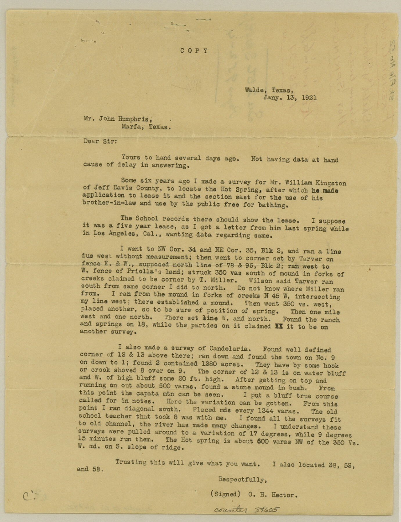
[Sketch and statement regarding location of Hot Springs in Block 2 D.&P. RR. Co., and correspondence regarding a survey of Candelaria]
-
Map/Doc
34605
-
Collection
General Map Collection
-
Object Dates
1/13/1921 (Creation Date)
1/25/1921 (File Date)
1/13/1921 (Correspondence Date)
3/23/1920 (Correspondence Date)
1/21/1921 (Correspondence Date)
3/1/1920 (Survey Date)
-
People and Organizations
O.H. Hector (Surveyor/Engineer)
H.B. Tarver (Surveyor/Engineer)
F.W. Cook (Surveyor/Engineer)
-
Counties
Presidio
-
Subjects
Surveying Sketch File
-
Height x Width
11.5 x 8.8 inches
29.2 x 22.4 cm
-
Medium
paper, print
-
Features
Hot Spring
Candelaria
Arroyo Caliente
Part of: General Map Collection
Kimble County Working Sketch 52

Print $20.00
- Digital $50.00
Kimble County Working Sketch 52
1953
Size 31.1 x 16.7 inches
Map/Doc 70120
Flight Mission No. BRE-3P, Frame 78, Nueces County

Print $20.00
- Digital $50.00
Flight Mission No. BRE-3P, Frame 78, Nueces County
1956
Size 18.5 x 22.2 inches
Map/Doc 86819
Hutchinson County Rolled Sketch 36

Print $20.00
- Digital $50.00
Hutchinson County Rolled Sketch 36
1888
Size 20.3 x 25.3 inches
Map/Doc 6293
McMullen County Working Sketch 57

Print $20.00
- Digital $50.00
McMullen County Working Sketch 57
1983
Size 29.5 x 18.8 inches
Map/Doc 70758
Flight Mission No. DCL-7C, Frame 30, Kenedy County

Print $20.00
- Digital $50.00
Flight Mission No. DCL-7C, Frame 30, Kenedy County
1943
Size 15.3 x 15.1 inches
Map/Doc 86022
Nueces County Rolled Sketch 44

Print $40.00
- Digital $50.00
Nueces County Rolled Sketch 44
1948
Size 40.0 x 60.8 inches
Map/Doc 9602
Reagan County Rolled Sketch 40

Print $40.00
- Digital $50.00
Reagan County Rolled Sketch 40
Size 90.0 x 39.3 inches
Map/Doc 9831
Aransas County Rolled Sketch 27A

Print $2.00
- Digital $50.00
Aransas County Rolled Sketch 27A
1930
Size 8.9 x 7.2 inches
Map/Doc 5058
Water-Shed of the Pease River Drainage Area

Print $6.00
- Digital $50.00
Water-Shed of the Pease River Drainage Area
Size 14.9 x 31.0 inches
Map/Doc 65102
Val Verde County Rolled Sketch 68

Print $20.00
- Digital $50.00
Val Verde County Rolled Sketch 68
1958
Size 17.6 x 18.7 inches
Map/Doc 8131
Val Verde County Working Sketch 79

Print $40.00
- Digital $50.00
Val Verde County Working Sketch 79
1973
Size 51.0 x 32.4 inches
Map/Doc 72214
Flight Mission No. DIX-6P, Frame 114, Aransas County

Print $20.00
- Digital $50.00
Flight Mission No. DIX-6P, Frame 114, Aransas County
1956
Size 19.1 x 23.0 inches
Map/Doc 83820
You may also like
Mason County Sketch File 10

Print $6.00
- Digital $50.00
Mason County Sketch File 10
1885
Size 12.8 x 11.6 inches
Map/Doc 30693


Val Verde County Working Sketch 40

Print $20.00
- Digital $50.00
Val Verde County Working Sketch 40
1943
Size 31.5 x 29.8 inches
Map/Doc 72175
Pecos County Working Sketch 51

Print $20.00
- Digital $50.00
Pecos County Working Sketch 51
1948
Size 22.5 x 21.9 inches
Map/Doc 71523
El Paso County Rolled Sketch 44

Print $129.00
- Digital $50.00
El Paso County Rolled Sketch 44
1902
Size 10.4 x 15.5 inches
Map/Doc 44430
Flight Mission No. DQN-5K, Frame 28, Calhoun County

Print $20.00
- Digital $50.00
Flight Mission No. DQN-5K, Frame 28, Calhoun County
1953
Size 18.5 x 22.1 inches
Map/Doc 84379
Cooke County Sketch File 14

Print $4.00
- Digital $50.00
Cooke County Sketch File 14
Size 10.3 x 8.2 inches
Map/Doc 19248
Newton County Rolled Sketch 27A

Print $20.00
- Digital $50.00
Newton County Rolled Sketch 27A
1961
Size 35.9 x 27.1 inches
Map/Doc 6857

Texas in 1835

Print $20.00
- Digital $50.00
Texas in 1835
1897
Size 13.4 x 15.3 inches
Map/Doc 93414
Smith County Sketch File 16

Print $116.00
- Digital $50.00
Smith County Sketch File 16
1966
Size 10.8 x 7.3 inches
Map/Doc 36781