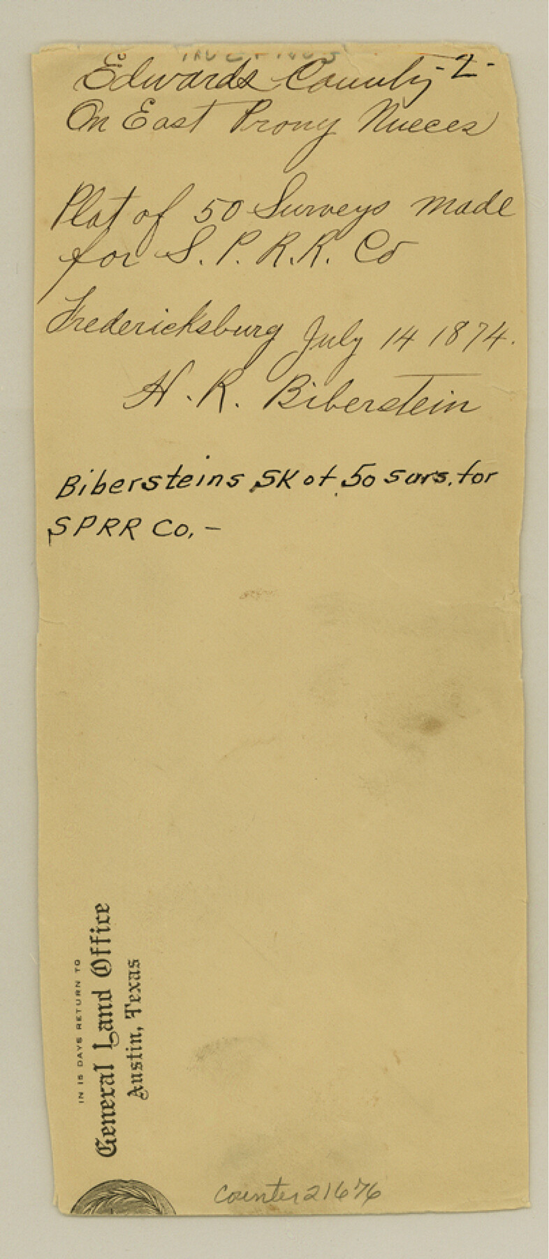
Edwards County Sketch File 2 and 3
[Sketch of fifty surveys made for S. P. RR. Co.]
-
Map/Doc
21676
-
Collection
General Map Collection
-
Object Dates
1874/7/14 (Creation Date)
1874/8/3 (File Date)
1877/7/14 (Survey Date)
-
People and Organizations
H.R. Biberstein (Surveyor/Engineer)
-
Counties
Edwards
-
Subjects
Surveying Sketch File
-
Height x Width
9.3 x 4.1 inches
23.6 x 10.4 cm
-
Medium
paper, manuscript
-
Features
Middle Prong of Nueces River
Bullhead Creek
Cedar Creek
East Prong of Nueces River
Part of: General Map Collection
Dawson County

Print $20.00
- Digital $50.00
Dawson County
1932
Size 47.1 x 40.9 inches
Map/Doc 66799
Map of New England and New York to illustrate Olney's school geography

Print $20.00
- Digital $50.00
Map of New England and New York to illustrate Olney's school geography
1844
Size 12.1 x 19.0 inches
Map/Doc 93538
Parker County Working Sketch 16

Print $20.00
- Digital $50.00
Parker County Working Sketch 16
1990
Map/Doc 71466
City of Mexia, Texas

Print $40.00
- Digital $50.00
City of Mexia, Texas
1961
Size 71.2 x 43.3 inches
Map/Doc 93671
Austin County Boundary File 5a

Print $6.00
- Digital $50.00
Austin County Boundary File 5a
Size 14.1 x 8.7 inches
Map/Doc 50252
Briscoe County

Print $20.00
- Digital $50.00
Briscoe County
1879
Size 24.8 x 21.7 inches
Map/Doc 3331
New Map of Texas with the Contiguous American and Mexican States

Print $20.00
- Digital $50.00
New Map of Texas with the Contiguous American and Mexican States
1836
Size 13.7 x 19.7 inches
Map/Doc 76795
Boundary Between the United States & Mexico Agreed upon by the Joint Commission under the Treaty of Guadalupe Hidalgo

Print $20.00
- Digital $50.00
Boundary Between the United States & Mexico Agreed upon by the Joint Commission under the Treaty of Guadalupe Hidalgo
1853
Size 18.3 x 26.7 inches
Map/Doc 72885
Baylor County Sketch File 31

Print $6.00
- Digital $50.00
Baylor County Sketch File 31
1880
Size 14.3 x 8.9 inches
Map/Doc 14235
Culberson County Working Sketch 76

Print $20.00
- Digital $50.00
Culberson County Working Sketch 76
1975
Size 33.4 x 43.1 inches
Map/Doc 68530
Montague County Working Sketch 34

Print $20.00
- Digital $50.00
Montague County Working Sketch 34
1979
Size 20.3 x 15.0 inches
Map/Doc 71100
Mills County Working Sketch 2

Print $20.00
- Digital $50.00
Mills County Working Sketch 2
1904
Size 12.7 x 15.8 inches
Map/Doc 71032
You may also like
Map of Trinity County Texas

Print $20.00
- Digital $50.00
Map of Trinity County Texas
1859
Size 21.5 x 30.6 inches
Map/Doc 4095
Flight Mission No. CRC-5R, Frame 21, Chambers County

Print $20.00
- Digital $50.00
Flight Mission No. CRC-5R, Frame 21, Chambers County
1956
Size 18.6 x 22.3 inches
Map/Doc 84943
Flight Mission No. BQY-15M, Frame 20, Harris County

Print $20.00
- Digital $50.00
Flight Mission No. BQY-15M, Frame 20, Harris County
1953
Size 18.6 x 22.3 inches
Map/Doc 85318
Zavalla County

Print $20.00
- Digital $50.00
Zavalla County
1879
Size 22.8 x 27.2 inches
Map/Doc 4182

Jones County Rolled Sketch 1

Print $20.00
- Digital $50.00
Jones County Rolled Sketch 1
1957
Size 26.1 x 28.3 inches
Map/Doc 6450
Culberson County Working Sketch 61

Print $40.00
- Digital $50.00
Culberson County Working Sketch 61
1974
Size 74.9 x 34.0 inches
Map/Doc 68515
Dallas County Working Sketch 10

Print $20.00
- Digital $50.00
Dallas County Working Sketch 10
1971
Size 22.6 x 22.7 inches
Map/Doc 68576
Flight Mission No. BRE-1P, Frame 142, Nueces County

Print $20.00
- Digital $50.00
Flight Mission No. BRE-1P, Frame 142, Nueces County
1956
Size 18.4 x 22.3 inches
Map/Doc 86702
Wichita County Sketch File 3

Print $8.00
- Digital $50.00
Wichita County Sketch File 3
1856
Size 7.2 x 16.3 inches
Map/Doc 40033
Gregg County Working Sketch 2

Print $20.00
- Digital $50.00
Gregg County Working Sketch 2
1931
Size 16.8 x 13.6 inches
Map/Doc 63268
Map of Hemphill County

Print $20.00
- Digital $50.00
Map of Hemphill County
1899
Size 41.2 x 38.5 inches
Map/Doc 95527