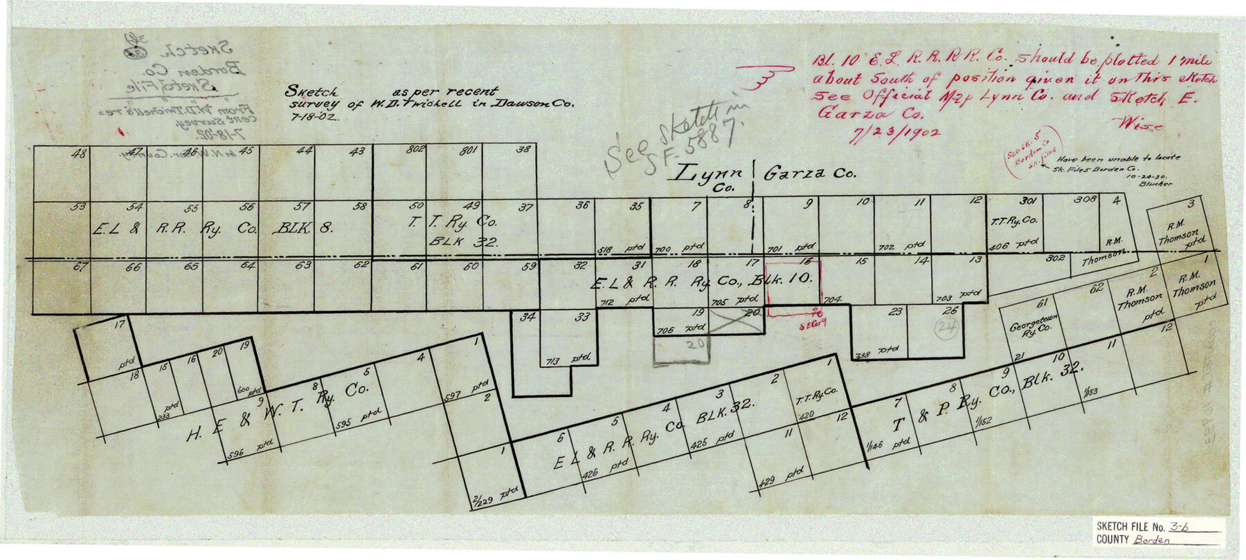
Borden County Sketch File 3b
[Sketch of area in northwest part of county]
-
Map/Doc
10933
-
Collection
General Map Collection
-
Object Dates
1902/7/18 (Creation Date)
-
People and Organizations
W.D. Twichell (Surveyor/Engineer)
-
Counties
Borden Garza Lynn
-
Subjects
Surveying Sketch File
-
Height x Width
9.5 x 21.1 inches
24.1 x 53.6 cm
-
Medium
linen, manuscript
Part of: General Map Collection
Flight Mission No. DIX-10P, Frame 144, Aransas County

Print $20.00
- Digital $50.00
Flight Mission No. DIX-10P, Frame 144, Aransas County
1956
Size 18.6 x 22.3 inches
Map/Doc 83946
Upshur County Working Sketch 16, revised

Print $20.00
- Digital $50.00
Upshur County Working Sketch 16, revised
1997
Size 42.9 x 37.2 inches
Map/Doc 69574
A Chart of the Internal Part of Louisiana

Print $20.00
- Digital $50.00
A Chart of the Internal Part of Louisiana
1810
Size 19.0 x 17.3 inches
Map/Doc 95155
Leon County Rolled Sketch 21

Print $20.00
- Digital $50.00
Leon County Rolled Sketch 21
Size 33.5 x 24.3 inches
Map/Doc 75971
Sherman County Sketch File 5

Print $2.00
- Digital $50.00
Sherman County Sketch File 5
1993
Size 14.6 x 9.0 inches
Map/Doc 36723
Waller County Sketch File 12

Print $6.00
- Digital $50.00
Waller County Sketch File 12
1928
Size 7.6 x 8.8 inches
Map/Doc 39616
Polk County Sketch File 36

Print $46.00
- Digital $50.00
Polk County Sketch File 36
1908
Size 13.8 x 8.6 inches
Map/Doc 34236
Navigation Maps of Gulf Intracoastal Waterway, Port Arthur to Brownsville, Texas

Print $4.00
- Digital $50.00
Navigation Maps of Gulf Intracoastal Waterway, Port Arthur to Brownsville, Texas
1951
Size 16.7 x 21.5 inches
Map/Doc 65421
Karnes County Sketch File 6

Print $4.00
- Digital $50.00
Karnes County Sketch File 6
1858
Size 7.7 x 8.1 inches
Map/Doc 28557
The American Military Pocket Atlas; being an approved Collection of Correct Maps, both general and particular, of the British Colonies; Especially those which now are, or probably may be the Theatre of War

The American Military Pocket Atlas; being an approved Collection of Correct Maps, both general and particular, of the British Colonies; Especially those which now are, or probably may be the Theatre of War
1776
Map/Doc 97398
Goliad County Working Sketch 3

Print $40.00
- Digital $50.00
Goliad County Working Sketch 3
1916
Size 42.8 x 76.4 inches
Map/Doc 63193
Partie de l'Amerique Septentrionale, qui Comprend le Canada, la Louisiane, le Labrador, le Groenland, les Etats-Unis et la Floride, &c.

Print $20.00
- Digital $50.00
Partie de l'Amerique Septentrionale, qui Comprend le Canada, la Louisiane, le Labrador, le Groenland, les Etats-Unis et la Floride, &c.
1776
Size 31.2 x 23.4 inches
Map/Doc 95140
You may also like
Cass County Rolled Sketch 3

Print $20.00
- Digital $50.00
Cass County Rolled Sketch 3
1937
Size 34.9 x 34.6 inches
Map/Doc 8585
McCulloch County Sketch File 13

Print $4.00
- Digital $50.00
McCulloch County Sketch File 13
1982
Size 3.4 x 7.8 inches
Map/Doc 31201
Flight Mission No. DCL-7C, Frame 8, Kenedy County

Print $20.00
- Digital $50.00
Flight Mission No. DCL-7C, Frame 8, Kenedy County
1943
Size 15.4 x 15.2 inches
Map/Doc 86000
Pecos County Working Sketch 70

Print $20.00
- Digital $50.00
Pecos County Working Sketch 70
1957
Size 31.4 x 27.0 inches
Map/Doc 71542
Flight Mission No. DAG-17K, Frame 140, Matagorda County

Print $20.00
- Digital $50.00
Flight Mission No. DAG-17K, Frame 140, Matagorda County
1952
Size 16.5 x 16.1 inches
Map/Doc 86357
Armstrong County Sketch File 4a

Print $4.00
- Digital $50.00
Armstrong County Sketch File 4a
1883
Size 14.3 x 8.9 inches
Map/Doc 13687
Presidio County Sketch File 85

Print $6.00
- Digital $50.00
Presidio County Sketch File 85
1950
Size 14.3 x 8.9 inches
Map/Doc 34745
Hardeman County Working Sketch 3

Print $20.00
- Digital $50.00
Hardeman County Working Sketch 3
1919
Size 32.7 x 35.1 inches
Map/Doc 63384
Tarrant County Sketch File 19

Print $4.00
- Digital $50.00
Tarrant County Sketch File 19
Size 9.7 x 8.1 inches
Map/Doc 37721
Sabine County Working Sketch 14

Print $20.00
- Digital $50.00
Sabine County Working Sketch 14
1953
Size 29.3 x 38.6 inches
Map/Doc 63685
Crockett County Working Sketch 6

Print $20.00
- Digital $50.00
Crockett County Working Sketch 6
Size 20.7 x 21.7 inches
Map/Doc 68339
Presidio County Working Sketch 97

Print $20.00
- Digital $50.00
Presidio County Working Sketch 97
1978
Size 28.2 x 28.0 inches
Map/Doc 71774