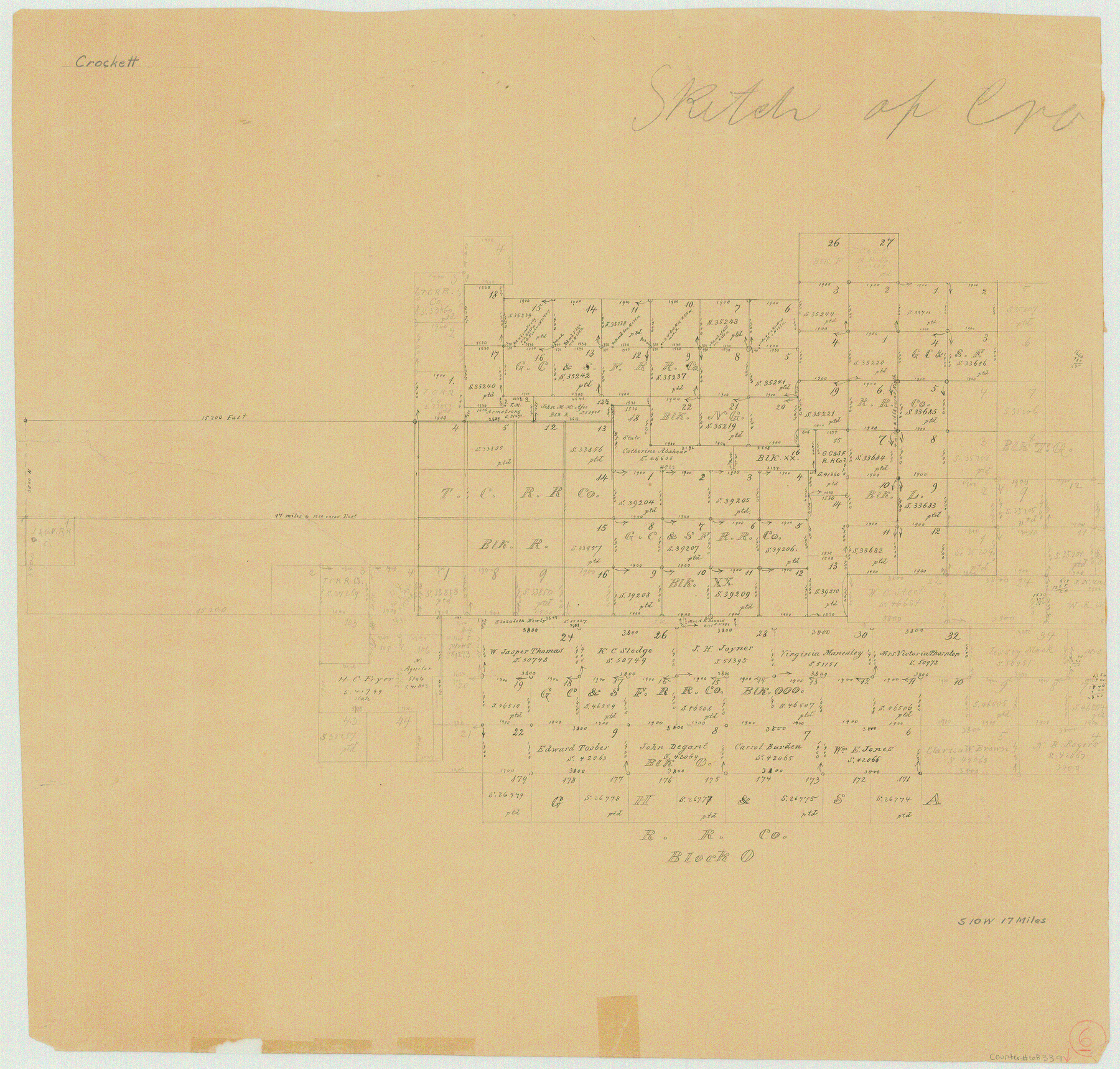
Crockett County Working Sketch 6
-
Map/Doc
68339
-
Collection
General Map Collection
-
Counties
Crockett
-
Subjects
Surveying Working Sketch
-
Height x Width
20.7 x 21.7 inches
52.6 x 55.1 cm
Part of: General Map Collection
Morris County Rolled Sketch 2A

Print $20.00
- Digital $50.00
Morris County Rolled Sketch 2A
Size 24.3 x 19.2 inches
Map/Doc 10251
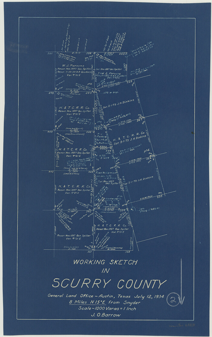
Scurry County Working Sketch 2
Print $3.00
- Digital $50.00
Scurry County Working Sketch 2
1934
Size 16.2 x 10.2 inches
Map/Doc 63831
Carte d'une partie de la Syrie et de la Palestine

Print $20.00
- Digital $50.00
Carte d'une partie de la Syrie et de la Palestine
1782
Size 12.8 x 17.9 inches
Map/Doc 97121
Flight Mission No. DIX-7P, Frame 85, Aransas County

Print $20.00
- Digital $50.00
Flight Mission No. DIX-7P, Frame 85, Aransas County
1956
Size 18.7 x 22.4 inches
Map/Doc 83879
Zavala County Sketch File 21

Print $4.00
- Digital $50.00
Zavala County Sketch File 21
1915
Size 11.5 x 8.8 inches
Map/Doc 41376
Morris County

Print $20.00
- Digital $50.00
Morris County
1906
Size 44.1 x 22.4 inches
Map/Doc 66944
Maps of Gulf Intracoastal Waterway, Texas - Sabine River to the Rio Grande and connecting waterways including ship channels

Print $20.00
- Digital $50.00
Maps of Gulf Intracoastal Waterway, Texas - Sabine River to the Rio Grande and connecting waterways including ship channels
1966
Size 14.5 x 21.2 inches
Map/Doc 61989
Llano County Sketch File 13

Print $4.00
- Digital $50.00
Llano County Sketch File 13
1891
Size 9.2 x 15.3 inches
Map/Doc 30387
Crockett County Rolled Sketch 77

Print $20.00
- Digital $50.00
Crockett County Rolled Sketch 77
1952
Size 26.9 x 28.6 inches
Map/Doc 5618
Sutton County Sketch File 18

Print $94.00
- Digital $50.00
Sutton County Sketch File 18
1893
Size 12.9 x 8.3 inches
Map/Doc 37410
Map of Texas and Pacific Ry. Company's Surveys in the 80 Mile Reserve

Print $40.00
- Digital $50.00
Map of Texas and Pacific Ry. Company's Surveys in the 80 Mile Reserve
1885
Size 41.5 x 91.8 inches
Map/Doc 60313
[Corpus Christi Bay, Padre Island, Mustang Island, Laguna de la Madre, King and Kenedy's Pasture]
![73043, [Corpus Christi Bay, Padre Island, Mustang Island, Laguna de la Madre, King and Kenedy's Pasture], General Map Collection](https://historictexasmaps.com/wmedia_w700/maps/73043.tif.jpg)
Print $20.00
- Digital $50.00
[Corpus Christi Bay, Padre Island, Mustang Island, Laguna de la Madre, King and Kenedy's Pasture]
Size 27.0 x 18.2 inches
Map/Doc 73043
You may also like
Harris County Sketch File 9

Print $4.00
- Digital $50.00
Harris County Sketch File 9
1861
Size 6.7 x 7.3 inches
Map/Doc 25340
Presidio County Sketch File 5a

Print $4.00
- Digital $50.00
Presidio County Sketch File 5a
1872
Size 12.9 x 8.3 inches
Map/Doc 34435
Railroad map of the state of Texas / compiled and engraved expressly for the American railroad manual.

Print $20.00
Railroad map of the state of Texas / compiled and engraved expressly for the American railroad manual.
1873
Size 13.4 x 9.5 inches
Map/Doc 93599
Flight Mission No. DQO-2K, Frame 101, Galveston County

Print $20.00
- Digital $50.00
Flight Mission No. DQO-2K, Frame 101, Galveston County
1952
Size 18.8 x 22.5 inches
Map/Doc 85028
Reagan County Working Sketch 32

Print $20.00
- Digital $50.00
Reagan County Working Sketch 32
1965
Size 43.9 x 37.1 inches
Map/Doc 71874
Brewster County Rolled Sketch 22A

Print $20.00
- Digital $50.00
Brewster County Rolled Sketch 22A
1910
Size 33.0 x 24.8 inches
Map/Doc 5202
[Meridian thru 19th St. Muni. Standpipe]
![92864, [Meridian thru 19th St. Muni. Standpipe], Twichell Survey Records](https://historictexasmaps.com/wmedia_w700/maps/92864-1.tif.jpg)
Print $20.00
- Digital $50.00
[Meridian thru 19th St. Muni. Standpipe]
Size 23.8 x 19.5 inches
Map/Doc 92864
General Land Office and State Reclamation Department - An Index Map

Print $20.00
- Digital $50.00
General Land Office and State Reclamation Department - An Index Map
1930
Size 25.8 x 16.4 inches
Map/Doc 3027
Jasper County Sketch File 30

Print $20.00
- Digital $50.00
Jasper County Sketch File 30
1948
Size 11.3 x 8.8 inches
Map/Doc 27858
[T.&P. Blocks 57 and 58, South to PSL Block 53]
![89763, [T.&P. Blocks 57 and 58, South to PSL Block 53], Twichell Survey Records](https://historictexasmaps.com/wmedia_w700/maps/89763-1.tif.jpg)
Print $40.00
- Digital $50.00
[T.&P. Blocks 57 and 58, South to PSL Block 53]
Size 30.5 x 68.7 inches
Map/Doc 89763
Coke County Boundary File 4

Print $44.00
- Digital $50.00
Coke County Boundary File 4
Size 14.3 x 8.7 inches
Map/Doc 51593
[Sketch showing T.&P. "B" Blocks in Tsp. 1S, Tsp. 2S, Tsp. 3S and Tsp. 4S]
![89747, [Sketch showing T.&P. "B" Blocks in Tsp. 1S, Tsp. 2S, Tsp. 3S and Tsp. 4S], Twichell Survey Records](https://historictexasmaps.com/wmedia_w700/maps/89747-1.tif.jpg)
Print $40.00
- Digital $50.00
[Sketch showing T.&P. "B" Blocks in Tsp. 1S, Tsp. 2S, Tsp. 3S and Tsp. 4S]
Size 49.4 x 42.5 inches
Map/Doc 89747