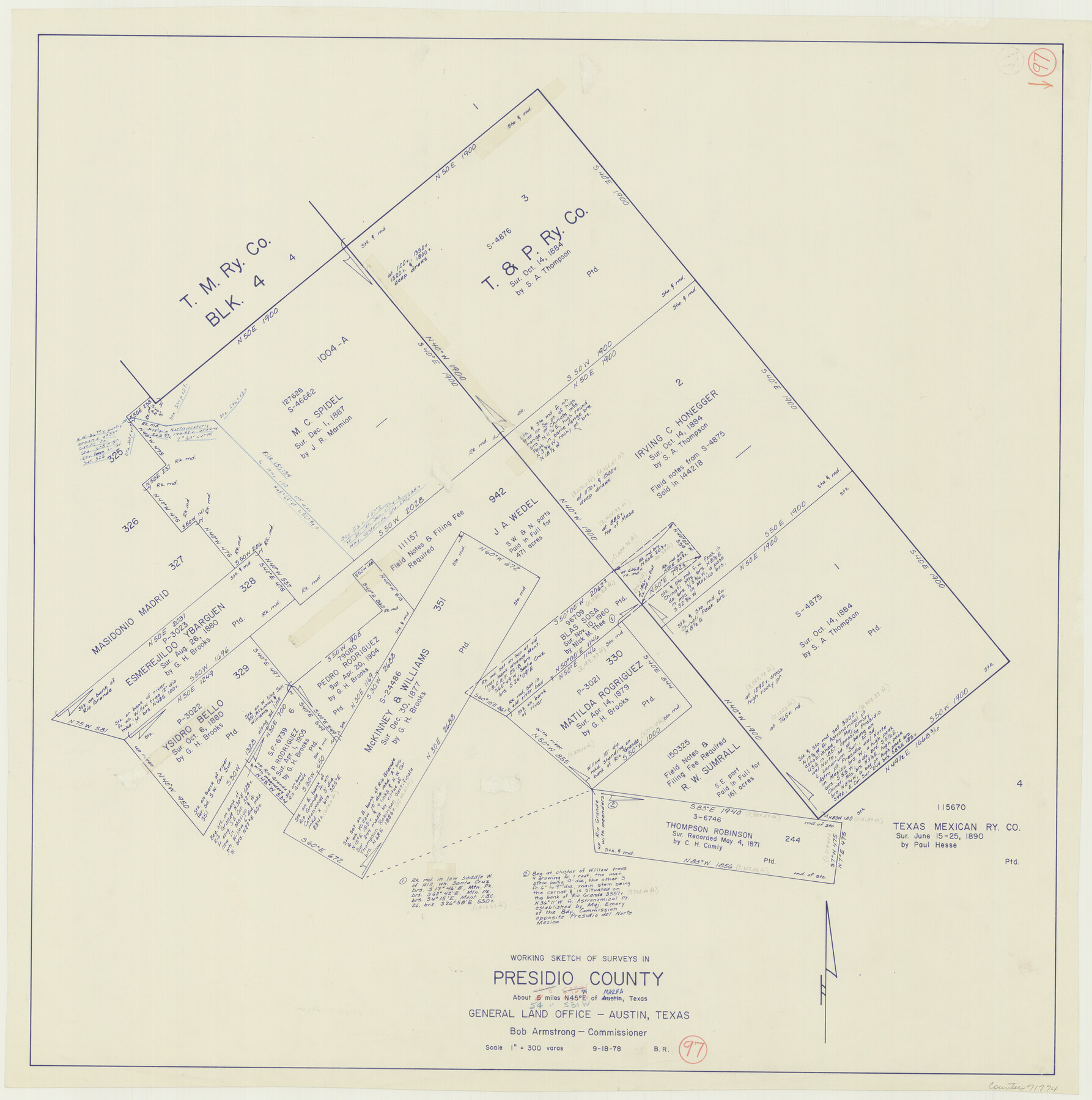
Presidio County Working Sketch 97
-
Map/Doc
71774
-
Collection
General Map Collection
-
Object Dates
9/18/1978 (Creation Date)
-
People and Organizations
Beverly Robison (Draftsman)
-
Counties
Presidio
-
Subjects
Surveying Working Sketch
-
Height x Width
28.2 x 28.0 inches
71.6 x 71.1 cm
-
Scale
1" = 300 varas
Part of: General Map Collection
Zavala County Rolled Sketch 14

Print $20.00
- Digital $50.00
Zavala County Rolled Sketch 14
1887
Size 28.1 x 40.8 inches
Map/Doc 10175
Brazoria County Rolled Sketch 33

Print $133.00
- Digital $50.00
Brazoria County Rolled Sketch 33
Size 10.3 x 15.4 inches
Map/Doc 42960
Dawson County Sketch File 24

Print $8.00
- Digital $50.00
Dawson County Sketch File 24
Size 12.5 x 8.7 inches
Map/Doc 20577
Nacogdoches County Sketch File 10

Print $6.00
- Digital $50.00
Nacogdoches County Sketch File 10
1886
Size 12.9 x 11.0 inches
Map/Doc 32253
Galveston County NRC Article 33.136 Sketch 49

Print $24.00
- Digital $50.00
Galveston County NRC Article 33.136 Sketch 49
2007
Size 24.0 x 36.0 inches
Map/Doc 94663
Map of Travis County

Print $40.00
- Digital $50.00
Map of Travis County
1895
Size 48.8 x 54.1 inches
Map/Doc 82083
Flight Mission No. DAG-21K, Frame 43, Matagorda County

Print $20.00
- Digital $50.00
Flight Mission No. DAG-21K, Frame 43, Matagorda County
1952
Size 18.9 x 22.6 inches
Map/Doc 86410
Flight Mission No. CRC-5R, Frame 21, Chambers County

Print $20.00
- Digital $50.00
Flight Mission No. CRC-5R, Frame 21, Chambers County
1956
Size 18.6 x 22.3 inches
Map/Doc 84943
Nueces County Rolled Sketch 95

Print $20.00
- Digital $50.00
Nueces County Rolled Sketch 95
1983
Size 18.2 x 24.7 inches
Map/Doc 7052
Bexar County Sketch File 36d

Print $40.00
- Digital $50.00
Bexar County Sketch File 36d
1878
Size 21.1 x 26.0 inches
Map/Doc 10923
Flight Mission No. CUI-1H, Frame 141, Milam County

Print $20.00
- Digital $50.00
Flight Mission No. CUI-1H, Frame 141, Milam County
1951
Size 18.4 x 22.3 inches
Map/Doc 86607
Motley County Sketch File 12 (N)

Print $3.00
- Digital $50.00
Motley County Sketch File 12 (N)
Size 20.0 x 18.4 inches
Map/Doc 42141
You may also like
[Blocks M-23, M-17, M-18, H, G, and vicinity]
![91140, [Blocks M-23, M-17, M-18, H, G, and vicinity], Twichell Survey Records](https://historictexasmaps.com/wmedia_w700/maps/91140-1.tif.jpg)
Print $20.00
- Digital $50.00
[Blocks M-23, M-17, M-18, H, G, and vicinity]
1882
Size 12.6 x 12.2 inches
Map/Doc 91140
Caldwell County Sketch File 3

Print $4.00
- Digital $50.00
Caldwell County Sketch File 3
1872
Size 12.7 x 8.1 inches
Map/Doc 35827
Red River County Working Sketch 29

Print $20.00
- Digital $50.00
Red River County Working Sketch 29
1961
Size 29.5 x 33.3 inches
Map/Doc 72012
Flight Mission No. DIX-8P, Frame 63, Aransas County

Print $20.00
- Digital $50.00
Flight Mission No. DIX-8P, Frame 63, Aransas County
1956
Size 18.7 x 22.5 inches
Map/Doc 83894
[Blocks L. E. and B8]
![90666, [Blocks L. E. and B8], Twichell Survey Records](https://historictexasmaps.com/wmedia_w700/maps/90666-2.tif.jpg)
Print $20.00
- Digital $50.00
[Blocks L. E. and B8]
Size 18.4 x 13.6 inches
Map/Doc 90666
General Highway Map, Collingsworth County, Texas

Print $20.00
General Highway Map, Collingsworth County, Texas
1940
Size 18.3 x 25.2 inches
Map/Doc 79053
Liberty County Sketch File B

Print $4.00
- Digital $50.00
Liberty County Sketch File B
1869
Size 12.0 x 8.2 inches
Map/Doc 30066
J. De Cordova's Map of the State of Texas Compiled from the records of the General Land Office of the State

Print $20.00
- Digital $50.00
J. De Cordova's Map of the State of Texas Compiled from the records of the General Land Office of the State
1849
Size 33.7 x 36.1 inches
Map/Doc 94026
Crockett County Working Sketch 86

Print $20.00
- Digital $50.00
Crockett County Working Sketch 86
1976
Size 34.7 x 38.0 inches
Map/Doc 68419
Bell County Rolled Sketch 2

Print $20.00
- Digital $50.00
Bell County Rolled Sketch 2
1954
Size 27.0 x 28.0 inches
Map/Doc 5133
Cass County Working Sketch Graphic Index

Print $20.00
- Digital $50.00
Cass County Working Sketch Graphic Index
1947
Size 39.1 x 41.9 inches
Map/Doc 76489
[Andrews County Road Map]
![92453, [Andrews County Road Map], Twichell Survey Records](https://historictexasmaps.com/wmedia_w700/maps/92453-1.tif.jpg)
Print $20.00
- Digital $50.00
[Andrews County Road Map]
1951
Size 18.6 x 25.6 inches
Map/Doc 92453