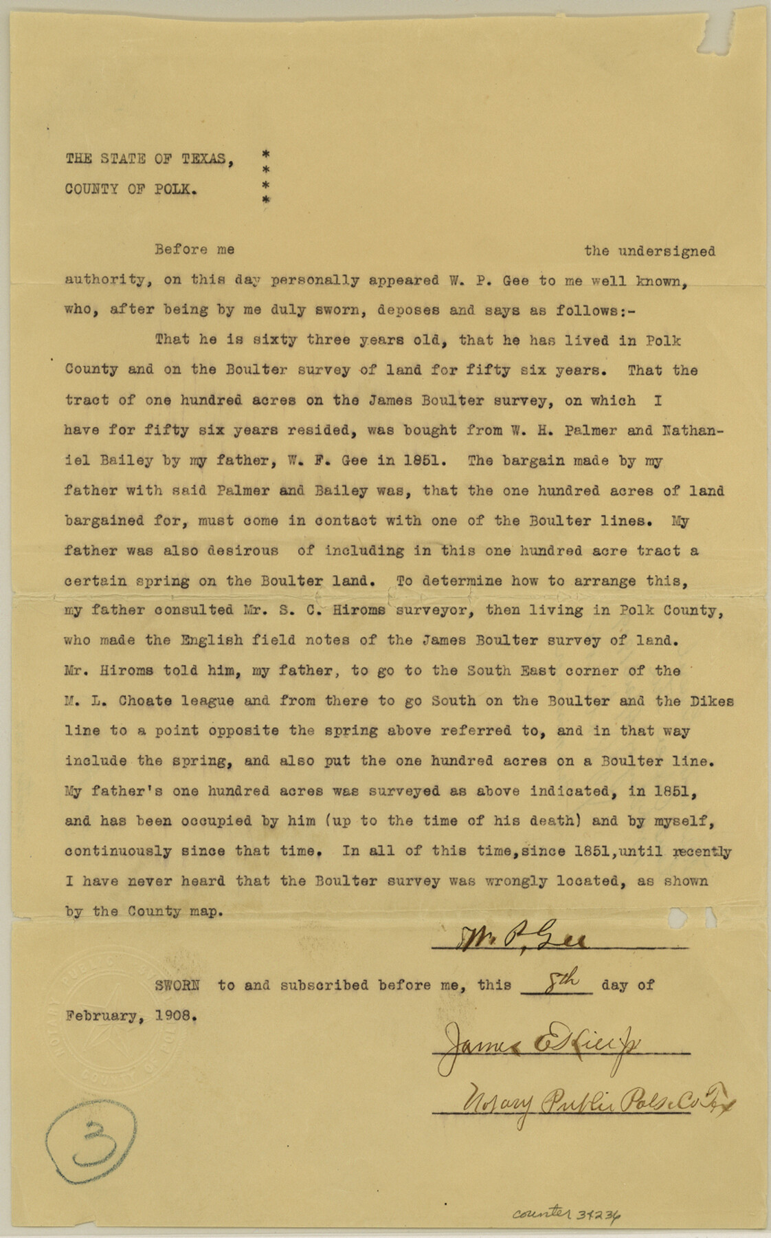
Polk County Sketch File 36
[Report and statements regarding the James Boulter and J. M. Dikes surveys]
-
Map/Doc
34236
-
Collection
General Map Collection
-
Object Dates
2/8/1908 (Creation Date)
4/13/1909 (File Date)
12/3/1907 (Creation Date)
6/17/1907 (Correspondence Date)
-
People and Organizations
W.H. Hill (Surveyor/Engineer)
B.J. Wilcoxon (Surveyor/Engineer)
C.A. Noblitt (Surveyor/Engineer)
A.B. Garvey (Surveyor/Engineer)
S.C. Hirams (Surveyor/Engineer)
H. Jackson (Surveyor/Engineer)
John E. Baumgarthen (Surveyor/Engineer)
W.H. Matthews (Surveyor/Engineer)
Wilcoxon (Surveyor/Engineer)
M.L. Choate (Chainman/Field Personnel)
D. McPherson (Chainman/Field Personnel)
I. White (Chainman/Field Personnel)
John R. Johnson (Surveyor/Engineer)
W.F. Gee (Surveyor/Engineer)
-
Counties
Polk
-
Subjects
Surveying Sketch File
-
Height x Width
13.8 x 8.6 inches
35.1 x 21.8 cm
-
Medium
multi-page, multi-format
-
Features
Long King Creek
Tempe Creek
Livingston and Liberty Road
Choates Creek
Part of: General Map Collection
Flight Mission No. BRA-16M, Frame 75, Jefferson County

Print $20.00
- Digital $50.00
Flight Mission No. BRA-16M, Frame 75, Jefferson County
1953
Size 18.6 x 22.3 inches
Map/Doc 85692
Panola County Working Sketch 41

Print $20.00
- Digital $50.00
Panola County Working Sketch 41
1995
Map/Doc 71450
Crane County Sketch File 4

Print $6.00
- Digital $50.00
Crane County Sketch File 4
Size 13.6 x 10.9 inches
Map/Doc 19562
Index for Texas Railroad ROW & track maps available on microfilm at THD & Archives and Records

Print $2.00
- Digital $50.00
Index for Texas Railroad ROW & track maps available on microfilm at THD & Archives and Records
1977
Size 11.1 x 8.6 inches
Map/Doc 60763
Leon County Rolled Sketch 5

Print $20.00
- Digital $50.00
Leon County Rolled Sketch 5
1947
Size 33.7 x 34.8 inches
Map/Doc 9427
Houston County Sketch File 40

Print $40.00
- Digital $50.00
Houston County Sketch File 40
Size 16.3 x 12.1 inches
Map/Doc 26826
Lee County Sketch File 9

Print $4.00
- Digital $50.00
Lee County Sketch File 9
Size 8.8 x 8.2 inches
Map/Doc 29709

Gulf Coast of the United States, Key West to Rio Grande

Print $20.00
- Digital $50.00
Gulf Coast of the United States, Key West to Rio Grande
1863
Size 27.3 x 18.2 inches
Map/Doc 72663
Ward County Working Sketch 12

Print $20.00
- Digital $50.00
Ward County Working Sketch 12
1947
Size 23.4 x 22.7 inches
Map/Doc 72318
Flight Mission No. DAG-23K, Frame 180, Matagorda County

Print $20.00
- Digital $50.00
Flight Mission No. DAG-23K, Frame 180, Matagorda County
1953
Size 18.4 x 16.0 inches
Map/Doc 86515

You may also like
[Township 2 North, Blocks 32 and 33]
![91212, [Township 2 North, Blocks 32 and 33], Twichell Survey Records](https://historictexasmaps.com/wmedia_w700/maps/91212-1.tif.jpg)
Print $3.00
- Digital $50.00
[Township 2 North, Blocks 32 and 33]
Size 11.8 x 10.8 inches
Map/Doc 91212
Jack County Sketch File 18b

Print $4.00
- Digital $50.00
Jack County Sketch File 18b
Size 8.0 x 12.9 inches
Map/Doc 27557
Atascosa County Working Sketch 36

Print $20.00
- Digital $50.00
Atascosa County Working Sketch 36
2008
Size 29.4 x 44.5 inches
Map/Doc 88878
Van Zandt County Working Sketch 9

Print $20.00
- Digital $50.00
Van Zandt County Working Sketch 9
1982
Size 12.6 x 11.7 inches
Map/Doc 72259
Hall County Sketch File B and B1

Print $14.00
- Digital $50.00
Hall County Sketch File B and B1
Size 9.2 x 8.5 inches
Map/Doc 24780
Flight Mission No. DAH-9M, Frame 197, Orange County

Print $20.00
- Digital $50.00
Flight Mission No. DAH-9M, Frame 197, Orange County
1953
Size 18.5 x 22.4 inches
Map/Doc 86865
Coast Chart No. 210 Aransas Pass and Corpus Christi Bay with the coast to latitude 27° 12' Texas

Print $20.00
- Digital $50.00
Coast Chart No. 210 Aransas Pass and Corpus Christi Bay with the coast to latitude 27° 12' Texas
1887
Size 27.6 x 18.2 inches
Map/Doc 72789
PSL Field Notes for Blocks 99, 100, 101, 103, 104, 105, 106, 107, 108, and 109 in Culberson County

PSL Field Notes for Blocks 99, 100, 101, 103, 104, 105, 106, 107, 108, and 109 in Culberson County
Map/Doc 81665
[Block C39, Sections 22, 23 Millican Estate, 24]
![92345, [Block C39, Sections 22, 23 Millican Estate, 24], Twichell Survey Records](https://historictexasmaps.com/wmedia_w700/maps/92345-1.tif.jpg)
Print $20.00
- Digital $50.00
[Block C39, Sections 22, 23 Millican Estate, 24]
1956
Size 11.4 x 31.2 inches
Map/Doc 92345
Jasper County Sketch File 7

Print $22.00
- Digital $50.00
Jasper County Sketch File 7
Size 12.4 x 15.4 inches
Map/Doc 27775
[University Blocks 17 and 18, Block Z, C4, 194, 178, A2, C3]
![93199, [University Blocks 17 and 18, Block Z, C4, 194, 178, A2, C3], Twichell Survey Records](https://historictexasmaps.com/wmedia_w700/maps/93199-1.tif.jpg)
Print $40.00
- Digital $50.00
[University Blocks 17 and 18, Block Z, C4, 194, 178, A2, C3]
1882
Size 81.8 x 54.1 inches
Map/Doc 93199
Collin County Boundary File 18c

Print $12.00
- Digital $50.00
Collin County Boundary File 18c
Size 12.9 x 8.1 inches
Map/Doc 51733