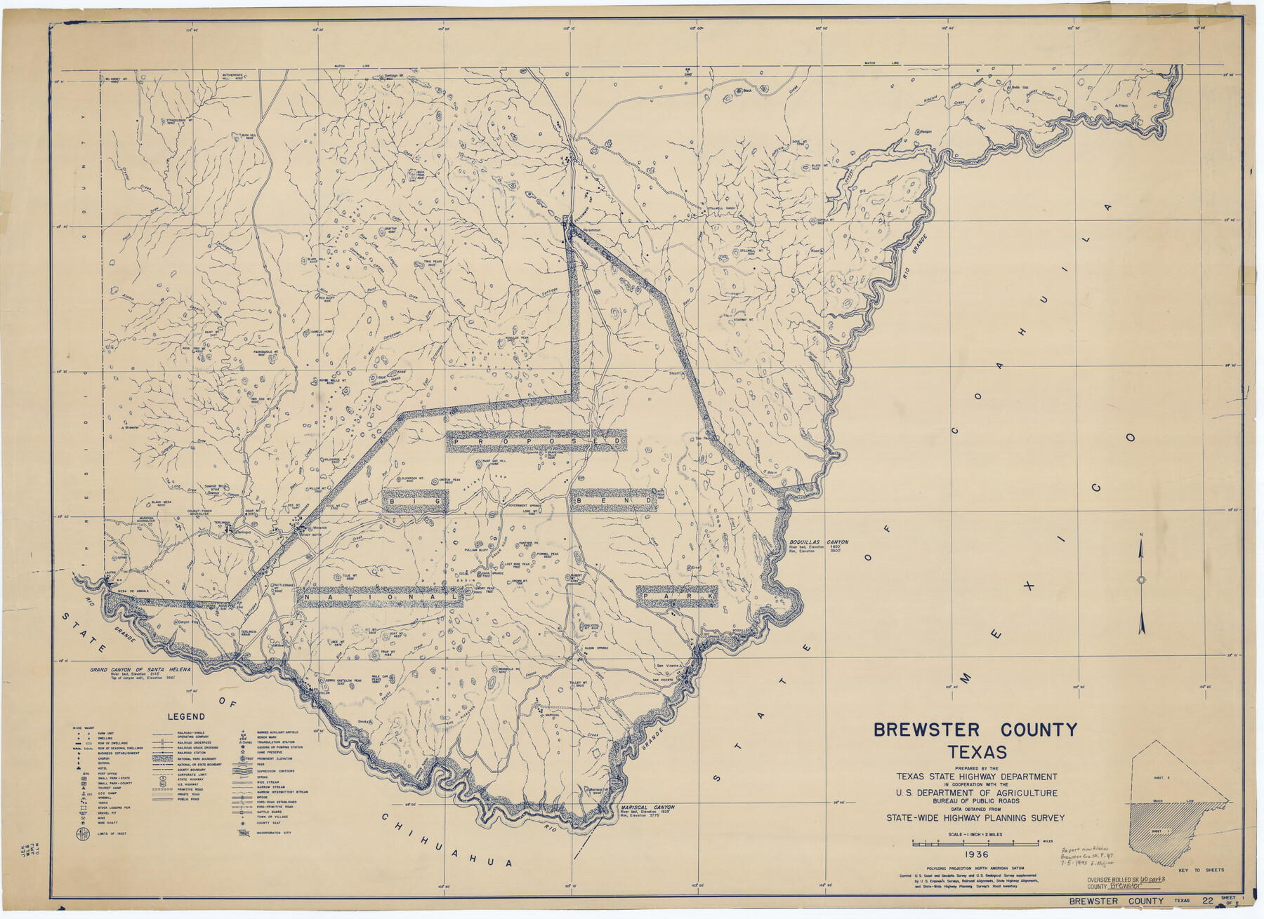
Brewster County Rolled Sketch 60
Brewster County, Texas
-
Map/Doc
10692
-
Collection
General Map Collection
-
Counties
Brewster
-
Subjects
Surveying Rolled Sketch
-
Height x Width
36.6 x 50.3 inches
93.0 x 127.8 cm
-
Medium
blueprint/diazo
-
Comments
See Brewster County Rolled Sketch 126 (43230) for surveyor’s report.
Related maps
Brewster County Sketch File 46

Print $16.00
- Digital $50.00
Brewster County Sketch File 46
1939
Size 9.3 x 6.2 inches
Map/Doc 16313
Brewster County Rolled Sketch 60

Print $40.00
- Digital $50.00
Brewster County Rolled Sketch 60
1942
Size 42.9 x 48.0 inches
Map/Doc 16960
Brewster County Rolled Sketch 126

Print $225.00
- Digital $50.00
Brewster County Rolled Sketch 126
1908
Map/Doc 43230
Brewster County Rolled Sketch 60

Print $20.00
- Digital $50.00
Brewster County Rolled Sketch 60
Size 24.8 x 36.5 inches
Map/Doc 61783
Brewster County Rolled Sketch 60

Print $40.00
- Digital $50.00
Brewster County Rolled Sketch 60
Size 53.9 x 28.0 inches
Map/Doc 61784
Brewster County Rolled Sketch 60

Print $20.00
- Digital $50.00
Brewster County Rolled Sketch 60
Size 25.0 x 37.5 inches
Map/Doc 8484
Brewster County Rolled Sketch 60

Print $40.00
- Digital $50.00
Brewster County Rolled Sketch 60
Size 37.1 x 68.9 inches
Map/Doc 8485
Brewster County Rolled Sketch 60

Print $40.00
- Digital $50.00
Brewster County Rolled Sketch 60
Size 36.7 x 50.8 inches
Map/Doc 9200
Part of: General Map Collection
Calhoun County Sketch File 2

Print $40.00
- Digital $50.00
Calhoun County Sketch File 2
1856
Size 20.2 x 15.8 inches
Map/Doc 11032
Navarro County Working Sketch 2

Print $20.00
- Digital $50.00
Navarro County Working Sketch 2
1922
Size 21.9 x 22.2 inches
Map/Doc 71232
Map of the Missouri Pacific Central Branch U.P.R.R. St. Louis, Iron Mountain & Southern International & Great Northern and Texas and Pacific Railways

Print $20.00
- Digital $50.00
Map of the Missouri Pacific Central Branch U.P.R.R. St. Louis, Iron Mountain & Southern International & Great Northern and Texas and Pacific Railways
1890
Size 28.7 x 24.4 inches
Map/Doc 97505
Montague County Working Sketch 14

Print $20.00
- Digital $50.00
Montague County Working Sketch 14
1940
Size 28.4 x 17.9 inches
Map/Doc 71080
Flight Mission No. DQN-2K, Frame 87, Calhoun County

Print $20.00
- Digital $50.00
Flight Mission No. DQN-2K, Frame 87, Calhoun County
1953
Size 18.9 x 22.6 inches
Map/Doc 84277
Taylor County Sketch File 10

Print $20.00
- Digital $50.00
Taylor County Sketch File 10
Size 35.2 x 34.4 inches
Map/Doc 10383
Bastrop County Working Sketch 5

Print $20.00
- Digital $50.00
Bastrop County Working Sketch 5
1923
Size 14.3 x 19.5 inches
Map/Doc 67305
Young County Working Sketch 6

Print $20.00
- Digital $50.00
Young County Working Sketch 6
1919
Size 12.2 x 11.9 inches
Map/Doc 62029
Val Verde County Rolled Sketch 38

Print $20.00
- Digital $50.00
Val Verde County Rolled Sketch 38
Size 29.8 x 19.7 inches
Map/Doc 8114
The Coast of New Spain from Neuva Vera Cruz to Triste Island

Print $20.00
- Digital $50.00
The Coast of New Spain from Neuva Vera Cruz to Triste Island
Size 21.0 x 28.9 inches
Map/Doc 95919
Map of Parmer County

Print $20.00
- Digital $50.00
Map of Parmer County
1900
Size 47.8 x 41.3 inches
Map/Doc 16786
Surveys on the lines [?] of Plum Creek
![78384, Surveys on the lines [?] of Plum Creek, General Map Collection](https://historictexasmaps.com/wmedia_w700/maps/78384.tif.jpg)
Print $2.00
- Digital $50.00
Surveys on the lines [?] of Plum Creek
Size 10.5 x 8.4 inches
Map/Doc 78384
You may also like
Eastland County Working Sketch 33

Print $20.00
- Digital $50.00
Eastland County Working Sketch 33
1956
Size 23.0 x 12.4 inches
Map/Doc 68814
Lubbock County Sketch File 2

Print $4.00
- Digital $50.00
Lubbock County Sketch File 2
Size 4.7 x 9.2 inches
Map/Doc 30418
Flight Mission No. DAG-18K, Frame 68, Matagorda County

Print $20.00
- Digital $50.00
Flight Mission No. DAG-18K, Frame 68, Matagorda County
1952
Size 16.4 x 16.3 inches
Map/Doc 86361
Nueces County Rolled Sketch 53

Print $63.00
- Digital $50.00
Nueces County Rolled Sketch 53
1978
Size 10.1 x 15.1 inches
Map/Doc 47862
[Strip along North line of Glasscock County School Land]
![90556, [Strip along North line of Glasscock County School Land], Twichell Survey Records](https://historictexasmaps.com/wmedia_w700/maps/90556-1.tif.jpg)
Print $2.00
- Digital $50.00
[Strip along North line of Glasscock County School Land]
Size 4.3 x 6.5 inches
Map/Doc 90556
Tarrant County Sketch File 2

Print $4.00
- Digital $50.00
Tarrant County Sketch File 2
1857
Size 7.0 x 6.5 inches
Map/Doc 37674
Sutton County Working Sketch 8

Print $20.00
- Digital $50.00
Sutton County Working Sketch 8
Size 14.2 x 21.6 inches
Map/Doc 62351
Edwards County Working Sketch 65

Print $20.00
- Digital $50.00
Edwards County Working Sketch 65
1956
Size 34.0 x 25.0 inches
Map/Doc 68941
[Sketch showing parts of Blocks 3, 5, 22, M-20, S, T and Block BB, surveys 1, 2 and 3]
![91729, [Sketch showing parts of Blocks 3, 5, 22, M-20, S, T and Block BB, surveys 1, 2 and 3], Twichell Survey Records](https://historictexasmaps.com/wmedia_w700/maps/91729-1.tif.jpg)
Print $20.00
- Digital $50.00
[Sketch showing parts of Blocks 3, 5, 22, M-20, S, T and Block BB, surveys 1, 2 and 3]
Size 15.9 x 15.3 inches
Map/Doc 91729
Ward County Working Sketch 30

Print $40.00
- Digital $50.00
Ward County Working Sketch 30
1964
Size 118.5 x 43.4 inches
Map/Doc 72336
Flight Mission No. DQO-8K, Frame 41, Galveston County

Print $20.00
- Digital $50.00
Flight Mission No. DQO-8K, Frame 41, Galveston County
1952
Size 18.7 x 22.3 inches
Map/Doc 85148
General Highway Map, Johnson County, Texas

Print $20.00
General Highway Map, Johnson County, Texas
1961
Size 18.2 x 24.8 inches
Map/Doc 79545