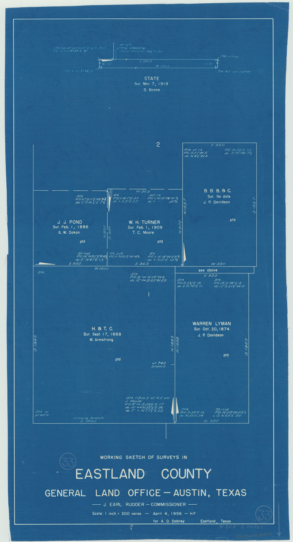
Eastland County Working Sketch 33
-
Map/Doc
68814
-
Collection
General Map Collection
-
Object Dates
4/4/1956 (Creation Date)
-
People and Organizations
Herman Forbes (Draftsman)
-
Counties
Eastland
-
Subjects
Surveying Working Sketch
-
Height x Width
23.0 x 12.4 inches
58.4 x 31.5 cm
-
Scale
1" = 300 varas
Part of: General Map Collection
Copy of Surveyor's Field Book, Morris Browning - In Blocks 7, 5 & 4, I&GNRRCo., Hutchinson and Carson Counties, Texas

Print $2.00
- Digital $50.00
Copy of Surveyor's Field Book, Morris Browning - In Blocks 7, 5 & 4, I&GNRRCo., Hutchinson and Carson Counties, Texas
1888
Size 6.9 x 8.8 inches
Map/Doc 62281
Henderson County Rolled Sketch 11

Print $20.00
- Digital $50.00
Henderson County Rolled Sketch 11
1915
Size 29.1 x 42.4 inches
Map/Doc 75948
Hardin County Working Sketch 30

Print $20.00
- Digital $50.00
Hardin County Working Sketch 30
1967
Size 24.6 x 20.3 inches
Map/Doc 63428
Leon County Working Sketch 53

Print $20.00
- Digital $50.00
Leon County Working Sketch 53
1982
Size 22.3 x 25.4 inches
Map/Doc 70453
Map of the River Sabine from its mouth on the Gulf of Mexico in the Sea to Logan's Ferry in Latitude 31°58'24" North

Print $40.00
- Digital $50.00
Map of the River Sabine from its mouth on the Gulf of Mexico in the Sea to Logan's Ferry in Latitude 31°58'24" North
1842
Size 67.6 x 30.6 inches
Map/Doc 87152
United States - Gulf Coast - Aransas Pass and Corpus Christi Bay with the coast to latitude 27° 12' Texas

Print $20.00
- Digital $50.00
United States - Gulf Coast - Aransas Pass and Corpus Christi Bay with the coast to latitude 27° 12' Texas
1913
Size 27.7 x 18.4 inches
Map/Doc 72795
Nueces County Rolled Sketch 116

Print $40.00
- Digital $50.00
Nueces County Rolled Sketch 116
Size 29.6 x 58.3 inches
Map/Doc 7141
Hamilton County Sketch File 7

Print $40.00
- Digital $50.00
Hamilton County Sketch File 7
1860
Size 12.2 x 15.3 inches
Map/Doc 24912
General Chart of the Coast No. XXI Gulf Coast from Galveston to the Rio Grande

Print $20.00
- Digital $50.00
General Chart of the Coast No. XXI Gulf Coast from Galveston to the Rio Grande
1883
Size 27.2 x 18.3 inches
Map/Doc 72728

Gregg County Working Sketch 16

Print $20.00
- Digital $50.00
Gregg County Working Sketch 16
1944
Size 14.8 x 27.9 inches
Map/Doc 63283
Zapata County Sketch File 20

Print $633.00
- Digital $50.00
Zapata County Sketch File 20
1998
Size 11.5 x 8.9 inches
Map/Doc 40966
You may also like
Atascosa County Sketch File 27b

Print $10.00
- Digital $50.00
Atascosa County Sketch File 27b
1875
Size 12.6 x 8.2 inches
Map/Doc 13801
Cottle County Sketch File 2

Print $20.00
- Digital $50.00
Cottle County Sketch File 2
1882
Size 32.9 x 19.6 inches
Map/Doc 76757
Flight Mission No. BQR-13K, Frame 24, Brazoria County

Print $20.00
- Digital $50.00
Flight Mission No. BQR-13K, Frame 24, Brazoria County
1952
Size 18.9 x 22.4 inches
Map/Doc 84072
Rusk County Sketch File 36

Print $20.00
Rusk County Sketch File 36
1950
Size 23.8 x 18.0 inches
Map/Doc 12274
Archer County Rolled Sketch E

Print $20.00
- Digital $50.00
Archer County Rolled Sketch E
Size 34.3 x 37.2 inches
Map/Doc 8424
Flight Mission No. CRC-2R, Frame 1, Chambers County

Print $20.00
- Digital $50.00
Flight Mission No. CRC-2R, Frame 1, Chambers County
1956
Size 18.7 x 22.5 inches
Map/Doc 84720
Nacogdoches County Sketch File 4

Print $4.00
- Digital $50.00
Nacogdoches County Sketch File 4
1858
Size 10.0 x 7.8 inches
Map/Doc 32241
[Capitol Leagues 225-238]
![90676, [Capitol Leagues 225-238], Twichell Survey Records](https://historictexasmaps.com/wmedia_w700/maps/90676-1.tif.jpg)
Print $20.00
- Digital $50.00
[Capitol Leagues 225-238]
Size 23.1 x 13.6 inches
Map/Doc 90676

General Highway Map Hockley County, Texas

Print $20.00
- Digital $50.00
General Highway Map Hockley County, Texas
1949
Size 25.7 x 18.8 inches
Map/Doc 92209
Bowie County Sketch File 7

Print $40.00
- Digital $50.00
Bowie County Sketch File 7
1927
Size 18.0 x 35.5 inches
Map/Doc 10943
Galveston County Rolled Sketch 20

Print $20.00
- Digital $50.00
Galveston County Rolled Sketch 20
1970
Size 35.0 x 35.0 inches
Map/Doc 9080