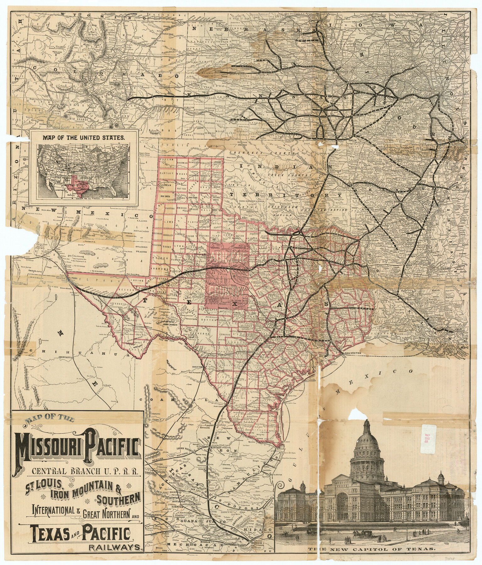
Map of the Missouri Pacific Central Branch U.P.R.R. St. Louis, Iron Mountain & Southern International & Great Northern and Texas and Pacific Railways
-
Map/Doc
97505
-
Collection
General Map Collection
-
Object Dates
1890 (Creation Date)
-
People and Organizations
Woodward & Tiernan Printing Co. (Printer)
-
Subjects
State of Texas Railroads
-
Height x Width
28.7 x 24.4 inches
72.9 x 62.0 cm
-
Comments
To view and download information on verso, please click the "Download PDF" link above.
Part of: General Map Collection
PSL Field Notes for Blocks G, L, P, and Q in Cochran and Yoakum Counties and Blocks U, V, W, Y, and Z in Cochran County

PSL Field Notes for Blocks G, L, P, and Q in Cochran and Yoakum Counties and Blocks U, V, W, Y, and Z in Cochran County
Map/Doc 81645
Brewster County Rolled Sketch B

Print $40.00
- Digital $50.00
Brewster County Rolled Sketch B
1882
Size 67.4 x 37.7 inches
Map/Doc 8465

Garza County Rolled Sketch 13

Print $26.00
- Digital $50.00
Garza County Rolled Sketch 13
1935
Size 45.5 x 36.7 inches
Map/Doc 9047
Flight Mission No. DQN-1K, Frame 131, Calhoun County

Print $20.00
- Digital $50.00
Flight Mission No. DQN-1K, Frame 131, Calhoun County
1953
Size 18.6 x 22.4 inches
Map/Doc 84194
Houston County Sketch File 38

Print $8.00
- Digital $50.00
Houston County Sketch File 38
Size 12.8 x 8.3 inches
Map/Doc 26821
Outline Map of Grayson County Texas

Print $20.00
- Digital $50.00
Outline Map of Grayson County Texas
1913
Size 19.2 x 16.4 inches
Map/Doc 4552
Flight Mission No. DAH-17M, Frame 27, Orange County

Print $20.00
- Digital $50.00
Flight Mission No. DAH-17M, Frame 27, Orange County
1953
Size 18.6 x 22.3 inches
Map/Doc 86890
Bexar County Sketch File 47

Print $40.00
- Digital $50.00
Bexar County Sketch File 47
1896
Size 9.9 x 19.6 inches
Map/Doc 10925
Jackson County Sketch File 3

Print $34.00
- Digital $50.00
Jackson County Sketch File 3
1875
Size 7.9 x 7.7 inches
Map/Doc 27621
Erath County Sketch File 4

Print $8.00
- Digital $50.00
Erath County Sketch File 4
1853
Size 13.1 x 8.3 inches
Map/Doc 22259
Hartley County Sketch File 6

Print $20.00
- Digital $50.00
Hartley County Sketch File 6
Size 30.5 x 25.6 inches
Map/Doc 11698
You may also like
Brewster County Working Sketch 40

Print $20.00
- Digital $50.00
Brewster County Working Sketch 40
1944
Size 16.1 x 26.1 inches
Map/Doc 67574
Navasota River, Springfield Sheet

Print $20.00
- Digital $50.00
Navasota River, Springfield Sheet
1934
Size 41.5 x 37.8 inches
Map/Doc 65074
Sutton County Sketch File 8

Print $20.00
- Digital $50.00
Sutton County Sketch File 8
1891
Size 24.9 x 31.6 inches
Map/Doc 12379
Map of the River Sabine from its mouth on the Gulf of Mexico in the sea to Logan's Ferry

Print $20.00
- Digital $50.00
Map of the River Sabine from its mouth on the Gulf of Mexico in the sea to Logan's Ferry
1842
Size 37.5 x 9.4 inches
Map/Doc 93767
[Southwest corner Runnels County School Land League 3 and vicinity]
![93114, [Southwest corner Runnels County School Land League 3 and vicinity], Twichell Survey Records](https://historictexasmaps.com/wmedia_w700/maps/93114-1.tif.jpg)
Print $20.00
- Digital $50.00
[Southwest corner Runnels County School Land League 3 and vicinity]
Size 42.5 x 31.5 inches
Map/Doc 93114
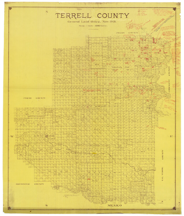
Terrell County Rolled Sketch 58
Print $40.00
- Digital $50.00
Terrell County Rolled Sketch 58
1931
Size 49.1 x 41.8 inches
Map/Doc 9993
Newton County

Print $20.00
- Digital $50.00
Newton County
1946
Size 46.8 x 40.9 inches
Map/Doc 77383
Current Miscellaneous File 24

Print $26.00
- Digital $50.00
Current Miscellaneous File 24
1953
Size 10.6 x 8.2 inches
Map/Doc 73883
Atascosa County

Print $20.00
- Digital $50.00
Atascosa County
1948
Size 47.2 x 46.3 inches
Map/Doc 95421
Sketches of Surveys in Montgomery Co.

Print $2.00
- Digital $50.00
Sketches of Surveys in Montgomery Co.
1845
Size 10.2 x 8.0 inches
Map/Doc 69731
Hale County Boundary File 10

Print $62.00
- Digital $50.00
Hale County Boundary File 10
Size 37.9 x 9.4 inches
Map/Doc 54145
San Patricio County NRC Article 33.136 Sketch 9

Print $82.00
San Patricio County NRC Article 33.136 Sketch 9
2022
Map/Doc 97031