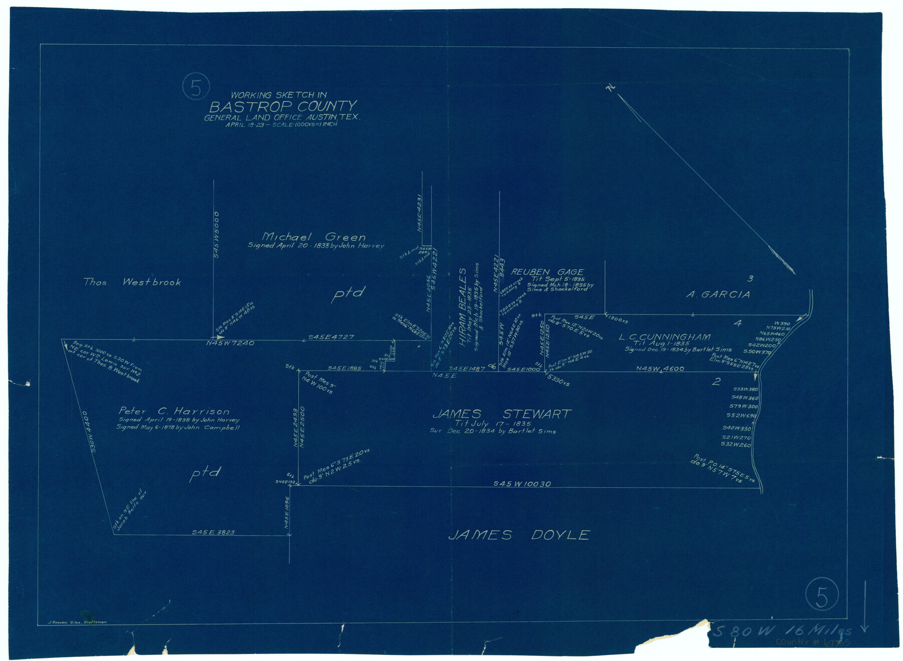
Bastrop County Working Sketch 5
-
Map/Doc
67305
-
Collection
General Map Collection
-
Object Dates
4/18/1923 (Creation Date)
-
People and Organizations
J. Bascom Giles (Draftsman)
-
Counties
Bastrop
-
Subjects
Surveying Working Sketch
-
Height x Width
14.3 x 19.5 inches
36.3 x 49.5 cm
-
Scale
1" = 1000 varas
-
Comments
Surveys located about 16 miles South 80 degrees West of Bastrop, Texas.
Part of: General Map Collection
Fort Bend County Working Sketch 3

Print $20.00
- Digital $50.00
Fort Bend County Working Sketch 3
1897
Size 26.8 x 24.6 inches
Map/Doc 69209
Kinney County Working Sketch 34

Print $20.00
- Digital $50.00
Kinney County Working Sketch 34
1963
Size 23.0 x 26.9 inches
Map/Doc 70216
Hardin County Working Sketch 44

Print $40.00
- Digital $50.00
Hardin County Working Sketch 44
1954
Size 53.1 x 39.5 inches
Map/Doc 69764
Partie de l'Amerique Septentrionale, qui Comprend le Canada, la Louisiane, le Labrador, le Groenland, les Etats-Unis et la Floride, &c.

Print $20.00
- Digital $50.00
Partie de l'Amerique Septentrionale, qui Comprend le Canada, la Louisiane, le Labrador, le Groenland, les Etats-Unis et la Floride, &c.
Size 31.2 x 23.4 inches
Map/Doc 95140
Frio County Working Sketch 25

Print $40.00
- Digital $50.00
Frio County Working Sketch 25
1989
Size 35.4 x 50.0 inches
Map/Doc 69299
Baylor County Sketch File 7

Print $4.00
- Digital $50.00
Baylor County Sketch File 7
Size 6.7 x 10.2 inches
Map/Doc 14135
Calhoun County Working Sketch 12

Print $20.00
- Digital $50.00
Calhoun County Working Sketch 12
1976
Size 35.2 x 47.7 inches
Map/Doc 67828
El Paso County Working Sketch 30

Print $40.00
- Digital $50.00
El Paso County Working Sketch 30
1967
Size 32.0 x 65.8 inches
Map/Doc 69052
Eastland County Working Sketch 24

Print $20.00
- Digital $50.00
Eastland County Working Sketch 24
1922
Size 36.1 x 27.1 inches
Map/Doc 68805
Nueces County NRC Article 33.136 Location Key Sheet

Print $20.00
- Digital $50.00
Nueces County NRC Article 33.136 Location Key Sheet
1975
Size 27.3 x 23.0 inches
Map/Doc 88587
Nueces River, Corpus Christi Sheet No. 4

Print $20.00
- Digital $50.00
Nueces River, Corpus Christi Sheet No. 4
1938
Size 32.3 x 42.8 inches
Map/Doc 65092
Jefferson County Working Sketch 3

Print $20.00
- Digital $50.00
Jefferson County Working Sketch 3
1904
Size 25.1 x 21.2 inches
Map/Doc 66546
You may also like
Flight Mission No. DAG-23K, Frame 167, Matagorda County

Print $20.00
- Digital $50.00
Flight Mission No. DAG-23K, Frame 167, Matagorda County
1953
Size 15.9 x 19.1 inches
Map/Doc 86505
[Sketch showing parts of Blocks 3, 5, 22, M-20, S, T and Block BB, surveys 1, 2 and 3]
![91730, [Sketch showing parts of Blocks 3, 5, 22, M-20, S, T and Block BB, surveys 1, 2 and 3], Twichell Survey Records](https://historictexasmaps.com/wmedia_w700/maps/91730-1.tif.jpg)
Print $20.00
- Digital $50.00
[Sketch showing parts of Blocks 3, 5, 22, M-20, S, T and Block BB, surveys 1, 2 and 3]
Size 15.5 x 15.9 inches
Map/Doc 91730
Andrews County Rolled Sketch 10

Print $40.00
- Digital $50.00
Andrews County Rolled Sketch 10
1931
Size 27.2 x 56.1 inches
Map/Doc 8389
General Highway Map, Walker County, Texas

Print $20.00
General Highway Map, Walker County, Texas
1940
Size 24.9 x 18.4 inches
Map/Doc 79269
Brewster County Working Sketch 113

Print $20.00
- Digital $50.00
Brewster County Working Sketch 113
1982
Size 29.4 x 38.2 inches
Map/Doc 67713
Brewster County Working Sketch 15a

Print $40.00
- Digital $50.00
Brewster County Working Sketch 15a
1953
Size 22.6 x 49.1 inches
Map/Doc 67549
Goliad County Sketch File 38

Print $4.00
- Digital $50.00
Goliad County Sketch File 38
1859
Size 13.0 x 8.1 inches
Map/Doc 24338
Flight Mission No. DCL-7C, Frame 136, Kenedy County

Print $20.00
- Digital $50.00
Flight Mission No. DCL-7C, Frame 136, Kenedy County
1943
Size 18.6 x 22.3 inches
Map/Doc 86093
[T. & P. Block 36, Townships 3N - 5N]
![90552, [T. & P. Block 36, Townships 3N - 5N], Twichell Survey Records](https://historictexasmaps.com/wmedia_w700/maps/90552.tif.jpg)
Print $20.00
- Digital $50.00
[T. & P. Block 36, Townships 3N - 5N]
Size 15.5 x 47.8 inches
Map/Doc 90552
Burnet County Working Sketch 25

Print $20.00
- Digital $50.00
Burnet County Working Sketch 25
2000
Size 24.2 x 30.3 inches
Map/Doc 67868
General Highway Map, Lynn County, Texas

Print $20.00
General Highway Map, Lynn County, Texas
1961
Size 18.1 x 24.6 inches
Map/Doc 79580
A Topographical Map of the City of Austin

Print $20.00
- Digital $50.00
A Topographical Map of the City of Austin
1872
Size 21.0 x 14.7 inches
Map/Doc 4821