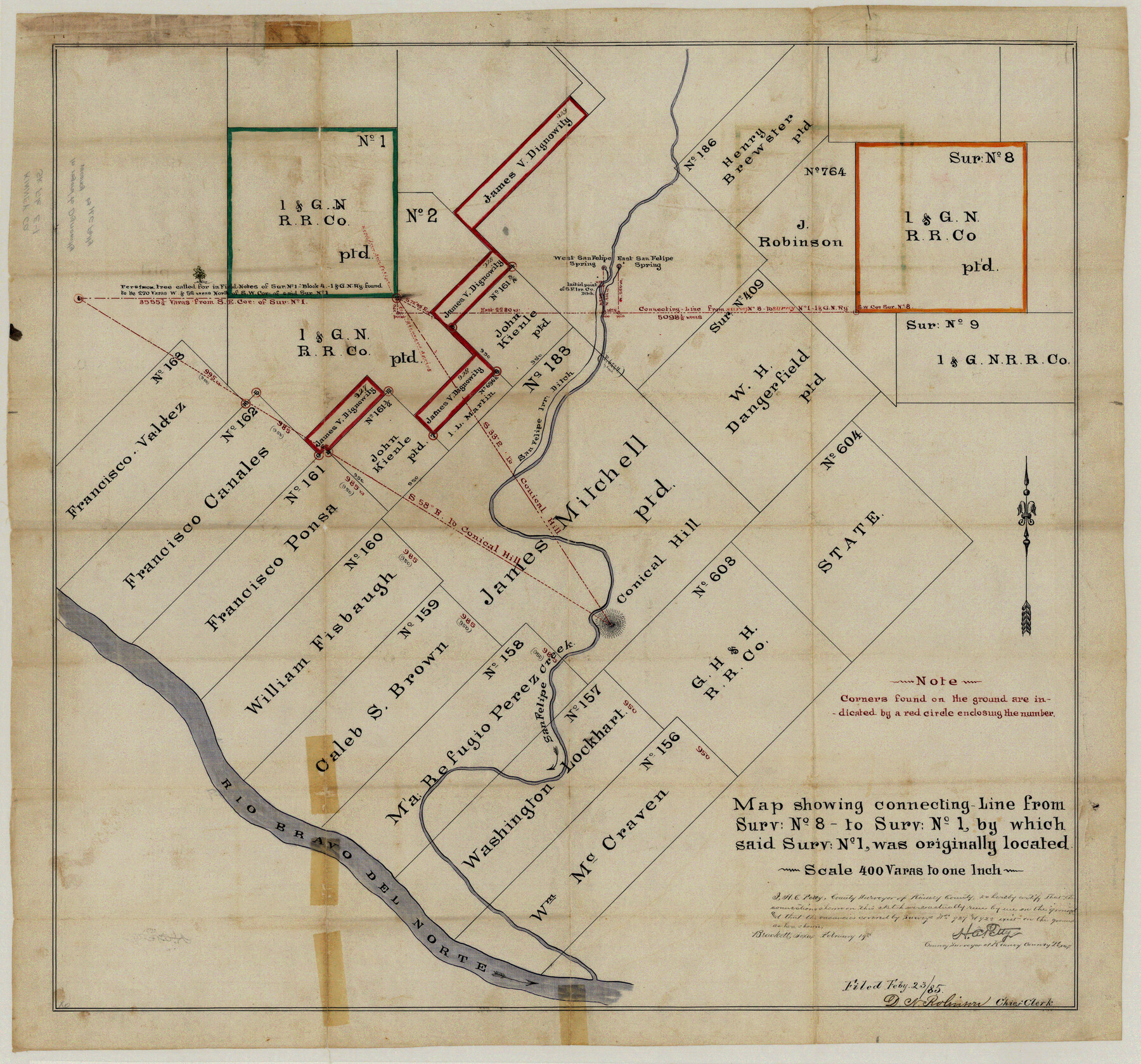
Kinney County Sketch File E1
Map showing connecting line from Surv. No. 8 to Surv. No. 1, by which said Surv. No. 1 was originally located
-
Map/Doc
10619
-
Collection
General Map Collection
-
Object Dates
2/19/1885 (Creation Date)
2/23/1885 (File Date)
-
People and Organizations
H.C. Petty (Surveyor/Engineer)
-
Counties
Val Verde
-
Subjects
Surveying Sketch File
-
Height x Width
29.8 x 31.9 inches
75.7 x 81.0 cm
-
Medium
paper, manuscript
-
Scale
1" = 400 varas
-
Features
West San Felipe Spring
East San Felipe Spring
San Felipe Irrigation Ditch
Conical Hill
San Felipe Creek
Rio Bravo del Norte
Part of: General Map Collection
Houston County Working Sketch 3

Print $20.00
- Digital $50.00
Houston County Working Sketch 3
Size 16.7 x 18.5 inches
Map/Doc 66233
Bastrop County Working Sketch 13

Print $20.00
- Digital $50.00
Bastrop County Working Sketch 13
1979
Size 23.6 x 30.0 inches
Map/Doc 67313
Map of Concho County

Print $20.00
- Digital $50.00
Map of Concho County
1879
Size 23.4 x 18.3 inches
Map/Doc 4523
Kendall County Working Sketch 22

Print $20.00
- Digital $50.00
Kendall County Working Sketch 22
1971
Size 41.6 x 34.7 inches
Map/Doc 66694
Hopkins County Sketch File 5

Print $4.00
- Digital $50.00
Hopkins County Sketch File 5
Size 10.3 x 8.2 inches
Map/Doc 26687
Midland County Working Sketch 24

Print $40.00
- Digital $50.00
Midland County Working Sketch 24
1957
Size 42.9 x 80.9 inches
Map/Doc 71005
Wilbarger Co.

Print $40.00
- Digital $50.00
Wilbarger Co.
1907
Size 49.1 x 40.3 inches
Map/Doc 63126
Montgomery County Working Sketch 66

Print $20.00
- Digital $50.00
Montgomery County Working Sketch 66
1967
Size 24.7 x 29.0 inches
Map/Doc 71173
Garza County Rolled Sketch 16

Print $20.00
- Digital $50.00
Garza County Rolled Sketch 16
Size 30.5 x 32.3 inches
Map/Doc 9048
Flight Mission No. CLL-3N, Frame 45, Willacy County

Print $20.00
- Digital $50.00
Flight Mission No. CLL-3N, Frame 45, Willacy County
1954
Size 18.4 x 22.1 inches
Map/Doc 87103
Harrison County Rolled Sketch 8

Print $33.00
- Digital $50.00
Harrison County Rolled Sketch 8
Size 10.1 x 15.2 inches
Map/Doc 45825
Flight Mission No. DCL-6C, Frame 6, Kenedy County

Print $20.00
- Digital $50.00
Flight Mission No. DCL-6C, Frame 6, Kenedy County
1943
Size 18.6 x 22.3 inches
Map/Doc 85866
You may also like
Houston Ship Channel, Alexander Island to Carpenter Bayou

Print $40.00
- Digital $50.00
Houston Ship Channel, Alexander Island to Carpenter Bayou
1992
Size 35.3 x 49.3 inches
Map/Doc 69917
J. De Cordova's Map of the State of Texas Compiled from the records of the General Land Office of the State

Print $20.00
- Digital $50.00
J. De Cordova's Map of the State of Texas Compiled from the records of the General Land Office of the State
1858
Size 31.6 x 29.6 inches
Map/Doc 2127
Jackson County Sketch File 6

Print $4.00
- Digital $50.00
Jackson County Sketch File 6
1897
Size 13.1 x 8.9 inches
Map/Doc 27632
Flight Mission No. CGI-3N, Frame 77, Cameron County

Print $20.00
- Digital $50.00
Flight Mission No. CGI-3N, Frame 77, Cameron County
1954
Size 18.6 x 22.2 inches
Map/Doc 84571
Galveston County Working Sketch 18

Print $20.00
- Digital $50.00
Galveston County Working Sketch 18
1982
Size 18.3 x 19.7 inches
Map/Doc 69355
Dimmit County Rolled Sketch 14

Print $40.00
- Digital $50.00
Dimmit County Rolled Sketch 14
1945
Size 56.6 x 36.0 inches
Map/Doc 8797
Jeff Davis County Sketch File 6

Print $20.00
- Digital $50.00
Jeff Davis County Sketch File 6
Size 33.0 x 30.2 inches
Map/Doc 10506
Matagorda County Rolled Sketch 9

Print $20.00
- Digital $50.00
Matagorda County Rolled Sketch 9
Size 36.8 x 30.0 inches
Map/Doc 6680
Austin Empresario Colony. January 17, 1821/February 18, 1823

Print $20.00
Austin Empresario Colony. January 17, 1821/February 18, 1823
2020
Size 18.8 x 21.6 inches
Map/Doc 95978
Leon County Sketch File 32

Print $4.00
- Digital $50.00
Leon County Sketch File 32
1955
Size 14.2 x 8.7 inches
Map/Doc 29832
Flight Mission No. CRK-5P, Frame 128, Refugio County

Print $20.00
- Digital $50.00
Flight Mission No. CRK-5P, Frame 128, Refugio County
1956
Size 18.6 x 22.5 inches
Map/Doc 86931
Young County Rolled Sketch 5

Print $20.00
- Digital $50.00
Young County Rolled Sketch 5
Size 20.2 x 26.1 inches
Map/Doc 8293