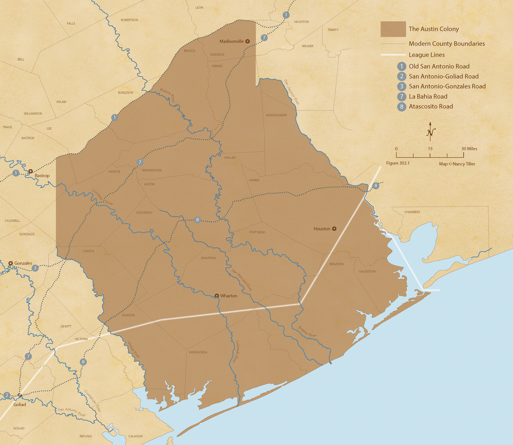
Austin Empresario Colony. January 17, 1821/February 18, 1823
Figure No. 302.1 from 'A Boundary Atlas of Texas, 1821-1845' by Jim Tiller
-
Map/Doc
95978
-
Collection
Nancy and Jim Tiller Digital Collection
-
Object Dates
1/1/2020 (Creation Date)
-
People and Organizations
Jim Tiller (Author)
Nancy Tiller (Cartographer)
Gang Gong (GIS Professional)
-
Subjects
Atlas Colony Mexican Texas Texas Boundaries
-
Height x Width
18.8 x 21.6 inches
47.8 x 54.9 cm
-
Medium
digital image
-
Comments
To purchase a digital PDF copy of "A Boundary Atlas of Texas, 1821-1845" see 96437.
Part of: Nancy and Jim Tiller Digital Collection
From Citizens of Liberty County for the Creation a New County to be Called Crockett, November 12, 1838

Print $20.00
From Citizens of Liberty County for the Creation a New County to be Called Crockett, November 12, 1838
2020
Size 22.3 x 21.7 inches
Map/Doc 96385
The Republic County of Lamar. January 3, 1844

Print $20.00
The Republic County of Lamar. January 3, 1844
2020
Size 16.4 x 21.7 inches
Map/Doc 96206
The Republic County of Shelby. Spring 1842

Print $20.00
The Republic County of Shelby. Spring 1842
2020
Size 20.0 x 21.7 inches
Map/Doc 96284
The Republic County of Jackson. December 29, 1845

Print $20.00
The Republic County of Jackson. December 29, 1845
2020
Size 15.6 x 21.8 inches
Map/Doc 96192
The Chief Justice County of Harrisburg. Lands in Conflict with Brazoria, Liberty Counties

Print $20.00
The Chief Justice County of Harrisburg. Lands in Conflict with Brazoria, Liberty Counties
2020
Size 17.5 x 21.7 inches
Map/Doc 96050
The Republic County of Shelby. December 14, 1837

Print $20.00
The Republic County of Shelby. December 14, 1837
2020
Size 21.1 x 21.7 inches
Map/Doc 96279

The d’Orvane Colony. June 3, 1842

Print $20.00
The d’Orvane Colony. June 3, 1842
2020
Size 13.1 x 21.7 inches
Map/Doc 96369
The Peters Colony. January 20, 1843

Print $20.00
The Peters Colony. January 20, 1843
2020
Size 17.2 x 21.7 inches
Map/Doc 96365
The Republic County of Harris. Spring 1842

Print $20.00
The Republic County of Harris. Spring 1842
2020
Size 17.7 x 21.7 inches
Map/Doc 96167
The Republic County of Gonzales. January 29, 1842

Print $20.00
The Republic County of Gonzales. January 29, 1842
2020
Size 14.7 x 21.7 inches
Map/Doc 96157
The Judicial District/County of Spring Creek. Created, January 21, 1841

Print $20.00
The Judicial District/County of Spring Creek. Created, January 21, 1841
2020
Size 15.7 x 21.7 inches
Map/Doc 96348
You may also like
Coast Chart No. 210 Aransas Pass and Corpus Christi Bay with the coast to latitude 27° 12' Texas

Print $20.00
- Digital $50.00
Coast Chart No. 210 Aransas Pass and Corpus Christi Bay with the coast to latitude 27° 12' Texas
1913
Size 27.6 x 18.2 inches
Map/Doc 72807
Township 5 South Range 13 West, South Western District, Louisiana

Print $20.00
- Digital $50.00
Township 5 South Range 13 West, South Western District, Louisiana
1879
Size 19.3 x 24.8 inches
Map/Doc 65885
![[San Benito Promotional Booklet]](https://historictexasmaps.com/wmedia_w700/pdf_converted_jpg/qi_pdf_thumbnail_64211.jpg)
Floyd County Sketch File 27

Print $6.00
- Digital $50.00
Floyd County Sketch File 27
1900
Size 14.4 x 8.9 inches
Map/Doc 22789
McMullen County Sketch File 39

Print $4.00
- Digital $50.00
McMullen County Sketch File 39
1938
Size 13.3 x 8.7 inches
Map/Doc 31413
Fractional Township No. 6 South Range No. 7 West of the Indian Meridian, Indian Territory

Print $20.00
- Digital $50.00
Fractional Township No. 6 South Range No. 7 West of the Indian Meridian, Indian Territory
1898
Size 19.4 x 24.3 inches
Map/Doc 75157
Travis County Sketch File 39

Print $20.00
- Digital $50.00
Travis County Sketch File 39
1914
Size 15.5 x 25.7 inches
Map/Doc 12463
Tom Green County Working Sketch 12

Print $20.00
- Digital $50.00
Tom Green County Working Sketch 12
1975
Size 30.0 x 41.1 inches
Map/Doc 69381
Jefferson County Sketch File 48

Print $20.00
- Digital $50.00
Jefferson County Sketch File 48
1875
Size 19.8 x 21.0 inches
Map/Doc 11882
Clay County Sketch File 39

Print $10.00
- Digital $50.00
Clay County Sketch File 39
1940
Size 14.3 x 8.7 inches
Map/Doc 18472
Jasper County Working Sketch 12

Print $40.00
- Digital $50.00
Jasper County Working Sketch 12
1920
Size 50.6 x 38.3 inches
Map/Doc 66474
Cherokee County Sketch File 22a

Print $20.00
- Digital $50.00
Cherokee County Sketch File 22a
Size 17.5 x 14.6 inches
Map/Doc 11072