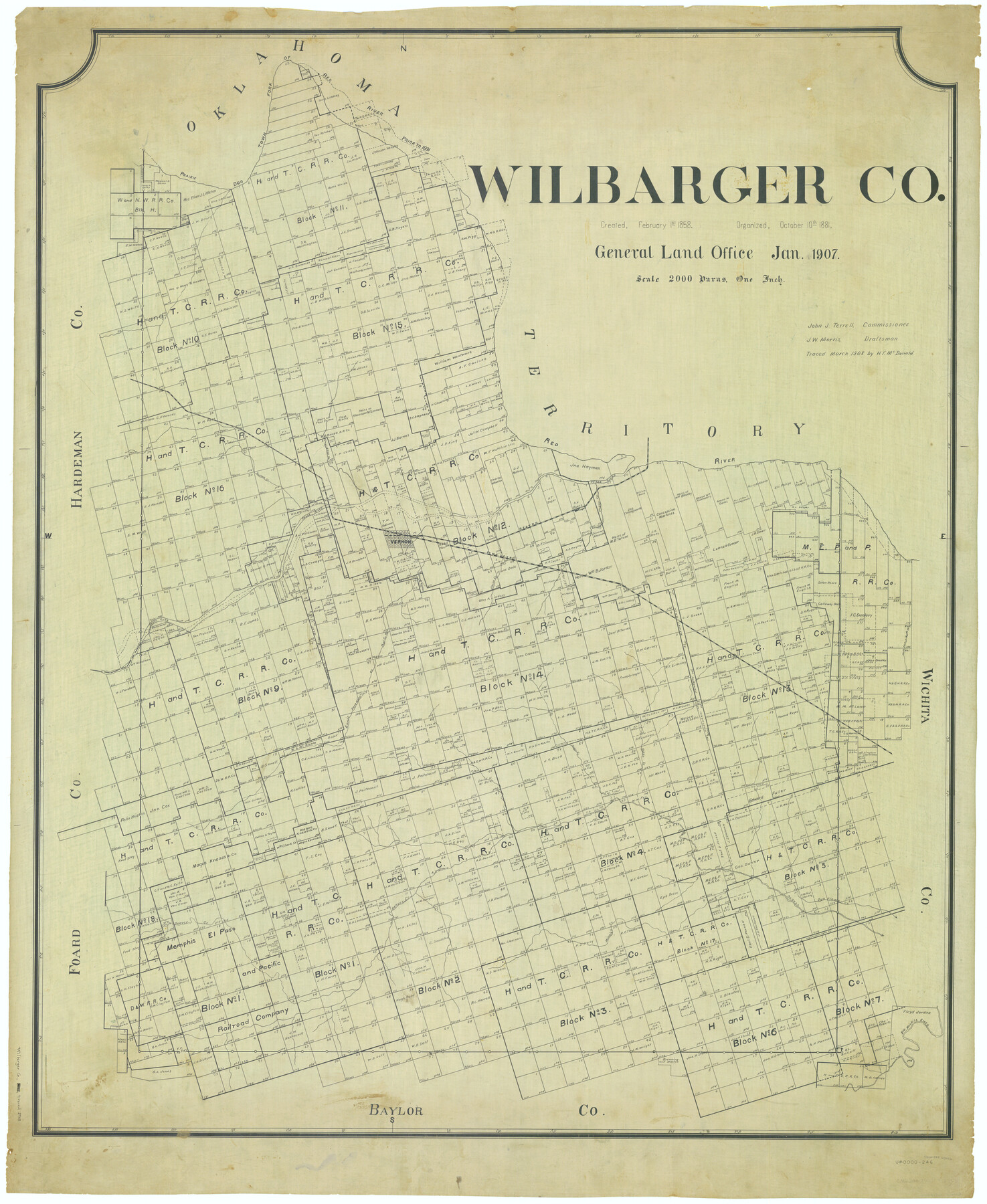
Wilbarger Co.
-
Map/Doc
63126
-
Collection
General Map Collection
-
Object Dates
1907 (Creation Date)
-
People and Organizations
Texas General Land Office (Publisher)
Jourdan W. Morris (Compiler)
John J. Terrell (GLO Commissioner)
Jourdan W. Morris (Draftsman)
-
Counties
Wilbarger
-
Subjects
County
-
Height x Width
49.1 x 40.3 inches
124.7 x 102.4 cm
-
Comments
Traced in March 1908 by H. F. McDonald.
Part of: General Map Collection
Travis County Sketch File 77

Print $26.00
- Digital $50.00
Travis County Sketch File 77
2004
Size 11.0 x 8.5 inches
Map/Doc 83254
Nueces County Rolled Sketch 79A

Print $20.00
- Digital $50.00
Nueces County Rolled Sketch 79A
1966
Size 17.7 x 25.7 inches
Map/Doc 9628
Somervell County Sketch File 5

Print $95.00
- Digital $50.00
Somervell County Sketch File 5
1871
Size 8.8 x 7.7 inches
Map/Doc 36802
[Photostats of section of Hydrographic Surveys H-5399, H-4822 and H-470, Mouth of Trinity River]
![61154, [Photostats of section of Hydrographic Surveys H-5399, H-4822 and H-470, Mouth of Trinity River], General Map Collection](https://historictexasmaps.com/wmedia_w700/maps/61154.tif.jpg)
Print $20.00
- Digital $50.00
[Photostats of section of Hydrographic Surveys H-5399, H-4822 and H-470, Mouth of Trinity River]
1933
Size 18.2 x 25.8 inches
Map/Doc 61154
Leon County Working Sketch 52a

Print $20.00
- Digital $50.00
Leon County Working Sketch 52a
1982
Size 35.1 x 42.8 inches
Map/Doc 70451
Montague County Working Sketch 6

Print $20.00
- Digital $50.00
Montague County Working Sketch 6
1923
Size 16.9 x 27.2 inches
Map/Doc 71072
Llano County Sketch File 12

Print $14.00
- Digital $50.00
Llano County Sketch File 12
1889
Size 14.0 x 8.5 inches
Map/Doc 30380
Randall County Rolled Sketch 9A

Print $20.00
- Digital $50.00
Randall County Rolled Sketch 9A
1985
Size 44.5 x 35.0 inches
Map/Doc 10314
Hardin County Sketch File 24a

Print $8.00
- Digital $50.00
Hardin County Sketch File 24a
1868
Size 5.8 x 7.9 inches
Map/Doc 25142
[Geological Map of Texas]
![62962, [Geological Map of Texas], General Map Collection](https://historictexasmaps.com/wmedia_w700/maps/62962.tif.jpg)
Print $20.00
- Digital $50.00
[Geological Map of Texas]
Size 17.6 x 18.1 inches
Map/Doc 62962
Fort Bend County State Real Property Sketch 15

Print $20.00
- Digital $50.00
Fort Bend County State Real Property Sketch 15
1985
Size 34.9 x 43.5 inches
Map/Doc 61689
Stonewall County Rolled Sketch 27

Print $20.00
- Digital $50.00
Stonewall County Rolled Sketch 27
Size 31.0 x 44.2 inches
Map/Doc 9966
You may also like
Brown County Working Sketch 5

Print $20.00
- Digital $50.00
Brown County Working Sketch 5
1939
Size 20.9 x 24.0 inches
Map/Doc 67770
Map of Survey in Dimmit and Webb Counties

Print $40.00
- Digital $50.00
Map of Survey in Dimmit and Webb Counties
1913
Size 31.3 x 71.0 inches
Map/Doc 75829
San Jacinto County Working Sketch 1

Print $20.00
- Digital $50.00
San Jacinto County Working Sketch 1
Size 30.0 x 29.6 inches
Map/Doc 63714
Amistad International Reservoir on Rio Grande 88

Print $20.00
- Digital $50.00
Amistad International Reservoir on Rio Grande 88
1949
Size 28.5 x 40.2 inches
Map/Doc 75517
Right of Way and Track Map Texas & New Orleans R.R. Co. operated by the T. & N. O. R.R. Co. Dallas-Sabine Branch

Print $40.00
- Digital $50.00
Right of Way and Track Map Texas & New Orleans R.R. Co. operated by the T. & N. O. R.R. Co. Dallas-Sabine Branch
1918
Size 26.4 x 56.6 inches
Map/Doc 64152
Flight Mission No. BRE-5P, Frame 199, Nueces County

Print $20.00
- Digital $50.00
Flight Mission No. BRE-5P, Frame 199, Nueces County
1956
Size 18.4 x 22.3 inches
Map/Doc 86839
South Part of Brewster Co.

Print $40.00
- Digital $50.00
South Part of Brewster Co.
1955
Size 48.8 x 40.0 inches
Map/Doc 66736
![3295, [Bell County], General Map Collection](https://historictexasmaps.com/wmedia_w700/maps/3295-1.tif.jpg)
Sutton County Working Sketch 44

Print $20.00
- Digital $50.00
Sutton County Working Sketch 44
1951
Size 29.8 x 27.5 inches
Map/Doc 62387
Angelina County Sketch File 18a

Print $5.00
- Digital $50.00
Angelina County Sketch File 18a
Size 7.7 x 12.0 inches
Map/Doc 13030
Galveston County NRC Article 33.136 Sketch 64

Print $26.00
- Digital $50.00
Galveston County NRC Article 33.136 Sketch 64
2010
Size 24.0 x 36.0 inches
Map/Doc 89990
Franklin County Working Sketch 2

Print $20.00
- Digital $50.00
Franklin County Working Sketch 2
1953
Size 33.3 x 29.9 inches
Map/Doc 69240