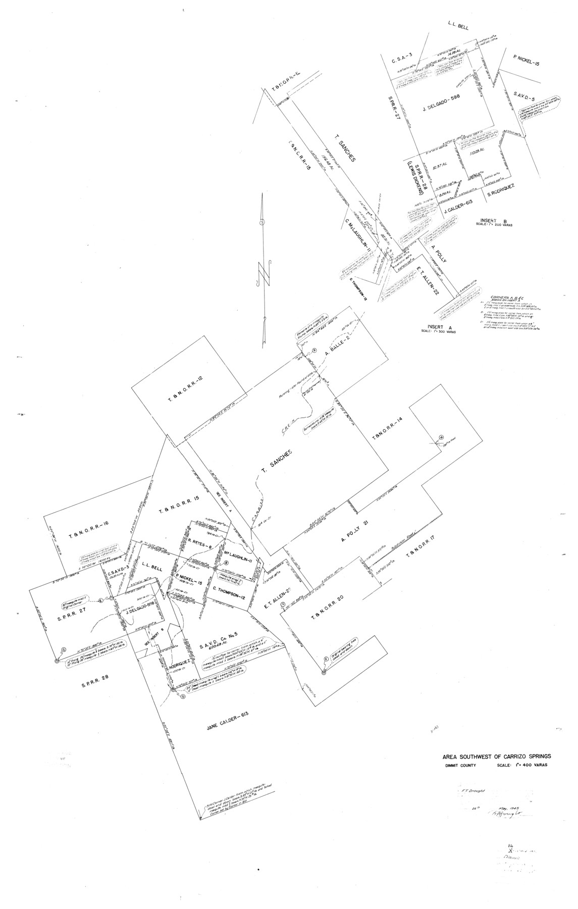
Dimmit County Rolled Sketch 14
Area southwest of Carrizo Springs
-
Map/Doc
8797
-
Collection
General Map Collection
-
Object Dates
1945/5/24 (Creation Date)
1945/6/22 (File Date)
-
People and Organizations
F.T. Drought (Surveyor/Engineer)
-
Counties
Dimmit
-
Subjects
Surveying Rolled Sketch
-
Height x Width
56.6 x 36.0 inches
143.8 x 91.4 cm
-
Scale
1" = 400 varas
Part of: General Map Collection
Orange County Sketch File 8

Print $6.00
- Digital $50.00
Orange County Sketch File 8
Size 11.0 x 16.1 inches
Map/Doc 33311
Gray County Boundary File 10

Print $15.00
- Digital $50.00
Gray County Boundary File 10
Size 14.5 x 9.0 inches
Map/Doc 53905
Hardin County Sketch File 41 and 42

Print $8.00
- Digital $50.00
Hardin County Sketch File 41 and 42
Size 8.8 x 7.9 inches
Map/Doc 25188
Upshur County Sketch File 13A

Print $20.00
- Digital $50.00
Upshur County Sketch File 13A
1936
Size 20.5 x 32.4 inches
Map/Doc 12503
La Salle County Working Sketch 53

Print $20.00
- Digital $50.00
La Salle County Working Sketch 53
Size 14.3 x 15.9 inches
Map/Doc 67362
Grayson County Working Sketch 7

Print $20.00
- Digital $50.00
Grayson County Working Sketch 7
1940
Size 41.1 x 27.7 inches
Map/Doc 63246
Gulf, Texas & Western Railway

Print $40.00
- Digital $50.00
Gulf, Texas & Western Railway
1909
Size 18.7 x 103.5 inches
Map/Doc 64431
Kinney County

Print $40.00
- Digital $50.00
Kinney County
1909
Size 48.4 x 42.7 inches
Map/Doc 16868
Val Verde County Working Sketch 57

Print $20.00
- Digital $50.00
Val Verde County Working Sketch 57
1958
Size 29.2 x 31.0 inches
Map/Doc 72192
Atascosa County Sketch File 21

Print $40.00
- Digital $50.00
Atascosa County Sketch File 21
Size 20.0 x 19.8 inches
Map/Doc 10859
Llano County Sketch File 19

Print $16.00
- Digital $50.00
Llano County Sketch File 19
1961
Size 14.2 x 8.7 inches
Map/Doc 30397

You may also like
Plan of the City of Austin

Print $40.00
- Digital $50.00
Plan of the City of Austin
1840
Size 55.5 x 38.9 inches
Map/Doc 4840
Dickens County Sketch File J

Print $12.00
- Digital $50.00
Dickens County Sketch File J
1904
Size 11.6 x 9.1 inches
Map/Doc 20883
Tyler County Working Sketch 16

Print $20.00
- Digital $50.00
Tyler County Working Sketch 16
1960
Size 46.0 x 41.8 inches
Map/Doc 69486
[T. & N. O. Railroad Company, Block 2T]
![91516, [T. & N. O. Railroad Company, Block 2T], Twichell Survey Records](https://historictexasmaps.com/wmedia_w700/maps/91516-1.tif.jpg)
Print $20.00
- Digital $50.00
[T. & N. O. Railroad Company, Block 2T]
Size 30.6 x 9.5 inches
Map/Doc 91516
Map Showing Jacob Kuechler's Meander of West Bank of Pecos River in December 1876

Print $20.00
- Digital $50.00
Map Showing Jacob Kuechler's Meander of West Bank of Pecos River in December 1876
Size 18.6 x 17.4 inches
Map/Doc 91669
Brewster County Sketch File NS-13

Print $4.00
- Digital $50.00
Brewster County Sketch File NS-13
1955
Size 11.1 x 8.8 inches
Map/Doc 16220
Flight Mission No. CGI-3N, Frame 71, Cameron County

Print $20.00
- Digital $50.00
Flight Mission No. CGI-3N, Frame 71, Cameron County
1954
Size 18.4 x 22.3 inches
Map/Doc 84565
Collingsworth County Working Sketch 6

Print $20.00
- Digital $50.00
Collingsworth County Working Sketch 6
1990
Size 37.7 x 41.8 inches
Map/Doc 68094
Jefferson County Rolled Sketch 52

Print $40.00
- Digital $50.00
Jefferson County Rolled Sketch 52
Size 28.2 x 52.9 inches
Map/Doc 9308
The Dividing Link - Mexico & Central America

The Dividing Link - Mexico & Central America
Size 20.5 x 31.2 inches
Map/Doc 95941
Val Verde County Sketch File 29

Print $20.00
- Digital $50.00
Val Verde County Sketch File 29
Size 33.1 x 23.8 inches
Map/Doc 76760
Kerr County Working Sketch 36

Print $20.00
- Digital $50.00
Kerr County Working Sketch 36
1991
Size 32.8 x 35.8 inches
Map/Doc 70067