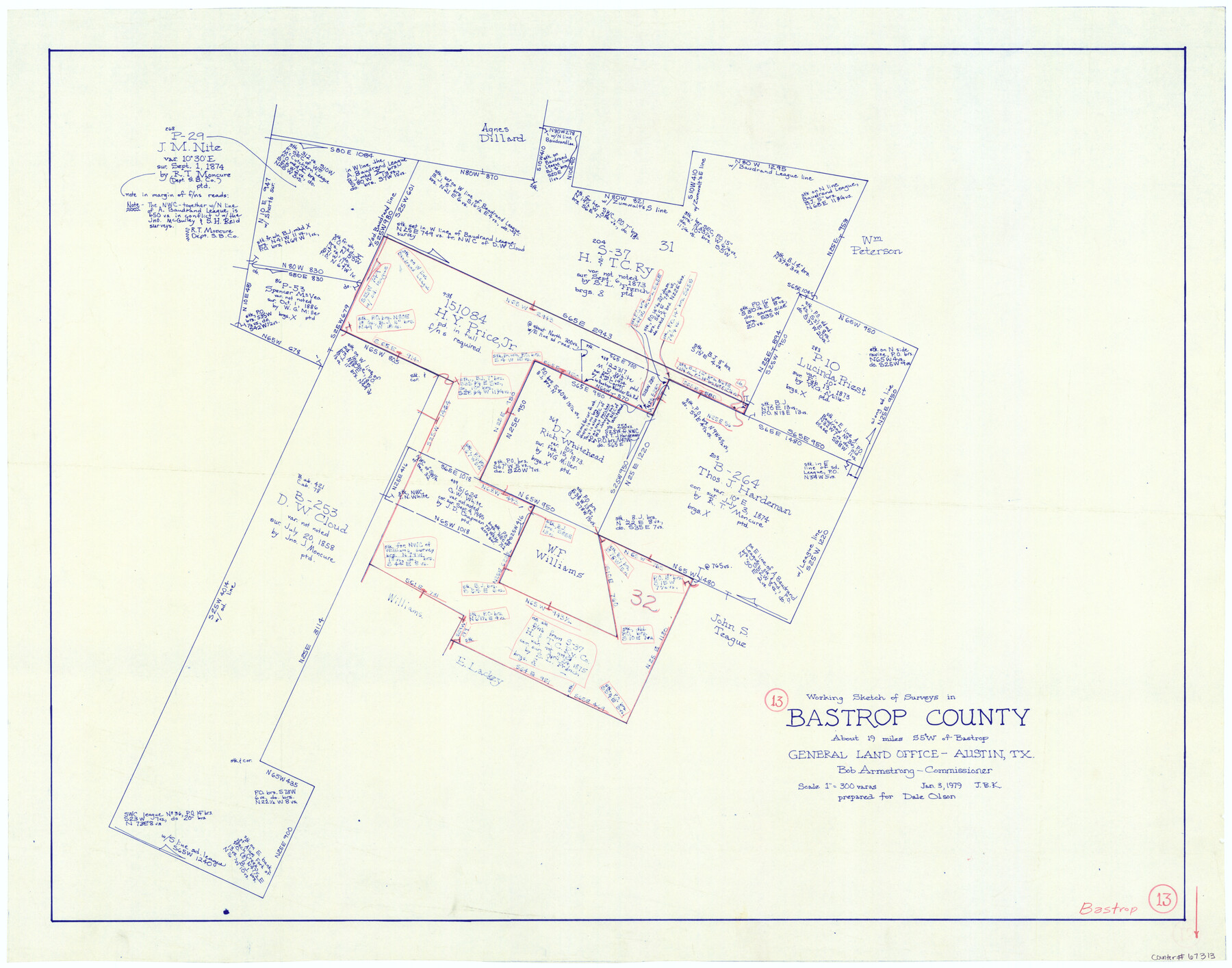
Bastrop County Working Sketch 13
-
Map/Doc
67313
-
Collection
General Map Collection
-
Object Dates
1/3/1979 (Creation Date)
-
People and Organizations
Joan Kilpatrick (Draftsman)
Bob Armstrong (GLO Commissioner)
-
Counties
Bastrop
-
Subjects
Surveying Working Sketch
-
Height x Width
23.6 x 30.0 inches
59.9 x 76.2 cm
-
Scale
1" = 300 varas
-
Comments
Surveys located about 19 miles South five degrees West of Bastrop, Texas.
Related maps
Bastrop County Sketch File 14

Print $6.00
- Digital $50.00
Bastrop County Sketch File 14
2018
Size 11.0 x 8.5 inches
Map/Doc 95248
Part of: General Map Collection
Flight Mission No. DCL-7C, Frame 96, Kenedy County

Print $20.00
- Digital $50.00
Flight Mission No. DCL-7C, Frame 96, Kenedy County
1943
Size 15.4 x 15.2 inches
Map/Doc 86068
Bandera County Sketch File 36

Print $6.00
- Digital $50.00
Bandera County Sketch File 36
Size 11.4 x 8.9 inches
Map/Doc 14034

[Surveys on Galveston and East Bay]
![248, [Surveys on Galveston and East Bay], General Map Collection](https://historictexasmaps.com/wmedia_w700/maps/248.tif.jpg)
Print $2.00
- Digital $50.00
[Surveys on Galveston and East Bay]
1846
Size 8.8 x 7.9 inches
Map/Doc 248
Tom Green County Sketch File 73

Print $12.00
- Digital $50.00
Tom Green County Sketch File 73
1949
Size 11.2 x 8.8 inches
Map/Doc 38244
Orange County Rolled Sketch 32

Print $20.00
- Digital $50.00
Orange County Rolled Sketch 32
1982
Size 33.6 x 22.5 inches
Map/Doc 7188
Winkler County Rolled Sketch 7

Print $20.00
- Digital $50.00
Winkler County Rolled Sketch 7
1929
Size 27.6 x 32.5 inches
Map/Doc 8273
Flight Mission No. DIX-5P, Frame 116, Aransas County

Print $20.00
- Digital $50.00
Flight Mission No. DIX-5P, Frame 116, Aransas County
1956
Size 17.8 x 18.1 inches
Map/Doc 83795
Knox County Sketch File 30

Print $15.00
- Digital $50.00
Knox County Sketch File 30
1904
Size 8.2 x 5.2 inches
Map/Doc 29264
Fort Bend County Working Sketch 29

Print $20.00
- Digital $50.00
Fort Bend County Working Sketch 29
1983
Size 21.6 x 19.2 inches
Map/Doc 69235
Red River County Working Sketch 25

Print $20.00
- Digital $50.00
Red River County Working Sketch 25
1959
Size 23.0 x 22.2 inches
Map/Doc 72008
Cooke County Sketch File 22

Print $6.00
- Digital $50.00
Cooke County Sketch File 22
1870
Size 6.4 x 8.2 inches
Map/Doc 19267
You may also like
Taylor County Sketch File 19

Print $10.00
- Digital $50.00
Taylor County Sketch File 19
1945
Size 14.2 x 8.8 inches
Map/Doc 37816
[PSL Block B-19]
![89811, [PSL Block B-19], Twichell Survey Records](https://historictexasmaps.com/wmedia_w700/maps/89811-1.tif.jpg)
Print $40.00
- Digital $50.00
[PSL Block B-19]
Size 43.7 x 56.6 inches
Map/Doc 89811
Culberson County Working Sketch 35

Print $20.00
- Digital $50.00
Culberson County Working Sketch 35
1963
Size 23.6 x 24.0 inches
Map/Doc 68488
Parker County Sketch File 33

Print $4.00
- Digital $50.00
Parker County Sketch File 33
Size 10.6 x 7.9 inches
Map/Doc 33576
[Val Verde County]
![63096, [Val Verde County], General Map Collection](https://historictexasmaps.com/wmedia_w700/maps/63096.tif.jpg)
Print $20.00
- Digital $50.00
[Val Verde County]
1898
Size 42.6 x 34.9 inches
Map/Doc 63096
[Leagues 615 ,616, and 242]
![91064, [Leagues 615 ,616, and 242], Twichell Survey Records](https://historictexasmaps.com/wmedia_w700/maps/91064-1.tif.jpg)
Print $20.00
- Digital $50.00
[Leagues 615 ,616, and 242]
Size 12.9 x 13.5 inches
Map/Doc 91064
Right of Way and Track Map, International & Gt. Northern Ry. Operated by the International & Gt. Northern Ry. Co., Gulf Division

Print $40.00
- Digital $50.00
Right of Way and Track Map, International & Gt. Northern Ry. Operated by the International & Gt. Northern Ry. Co., Gulf Division
1917
Size 25.2 x 55.9 inches
Map/Doc 64253
Comanche County Working Sketch 8

Print $20.00
- Digital $50.00
Comanche County Working Sketch 8
1950
Size 29.1 x 24.8 inches
Map/Doc 68142
Ector County Sketch File 9

Print $5.00
- Digital $50.00
Ector County Sketch File 9
1939
Size 28.7 x 22.2 inches
Map/Doc 11418
Flight Mission No. DIX-10P, Frame 70, Aransas County

Print $20.00
- Digital $50.00
Flight Mission No. DIX-10P, Frame 70, Aransas County
1956
Size 18.7 x 22.4 inches
Map/Doc 83931
Robertson County Sketch File 10

Print $22.00
Robertson County Sketch File 10
1846
Size 12.8 x 8.4 inches
Map/Doc 35392
Harris County Working Sketch 115

Print $40.00
- Digital $50.00
Harris County Working Sketch 115
1983
Size 48.8 x 44.5 inches
Map/Doc 66007