Upshur County Sketch File 17
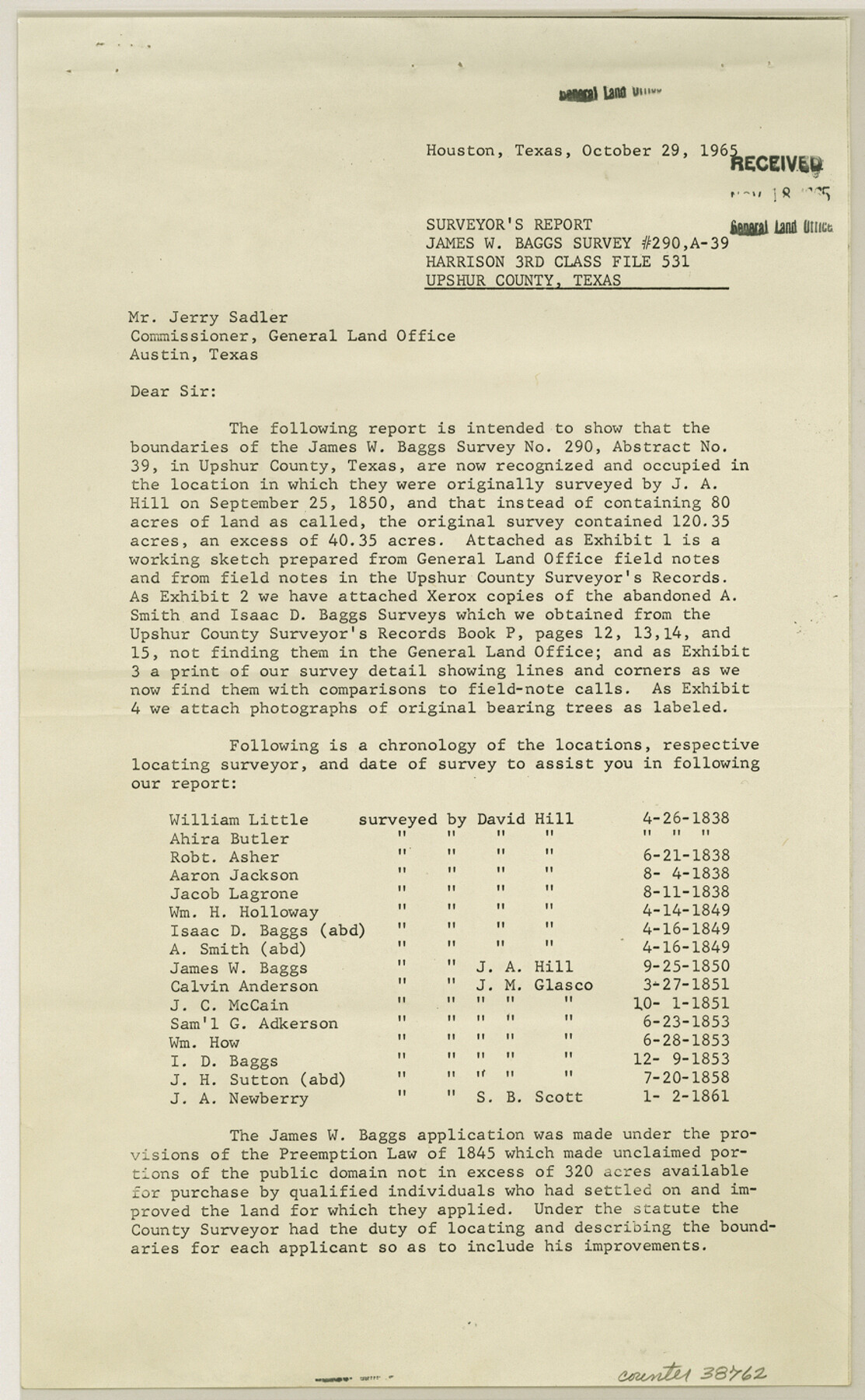
[Surveyor's report and sketches regarding James W. Baggs survey 290, abstract 39]
-
Map/Doc
10410
-
Collection
General Map Collection
-
Object Dates
10/29/1965 (Creation Date)
11/18/1965 (File Date)
-
People and Organizations
Ralph L. Andrews (Surveyor/Engineer)
-
Counties
Upshur
-
Subjects
Surveying Sketch File
-
Height x Width
35.4 x 31.8 inches
89.9 x 80.8 cm
-
Medium
multi-page, multi-format
-
Comments
See Upshur County Rolled Sketch 3 (8062) for sketch.
-
Features
Little Cypress Creek
Big Cypress Creek
SH 158
Related maps
Upshur County Rolled Sketch 3

Print $20.00
- Digital $50.00
Upshur County Rolled Sketch 3
1965
Size 35.3 x 30.0 inches
Map/Doc 8062
Part of: General Map Collection
Flight Mission No. BRA-17M, Frame 2, Jefferson County

Print $20.00
- Digital $50.00
Flight Mission No. BRA-17M, Frame 2, Jefferson County
1953
Size 18.6 x 22.3 inches
Map/Doc 85782
Dallam County Working Sketch Graphic Index

Print $40.00
- Digital $50.00
Dallam County Working Sketch Graphic Index
1926
Size 41.3 x 50.9 inches
Map/Doc 76516
Copy of Surveyor's Field Book, Morris Browning - In Blocks 7, 5 & 4, I&GNRRCo., Hutchinson and Carson Counties, Texas

Print $2.00
- Digital $50.00
Copy of Surveyor's Field Book, Morris Browning - In Blocks 7, 5 & 4, I&GNRRCo., Hutchinson and Carson Counties, Texas
1888
Size 6.9 x 8.8 inches
Map/Doc 62264
Reeves County Rolled Sketch 4

Print $20.00
- Digital $50.00
Reeves County Rolled Sketch 4
1891
Size 23.9 x 39.6 inches
Map/Doc 7476
El Paso County Sketch File 12

Print $22.00
- Digital $50.00
El Paso County Sketch File 12
1887
Size 8.1 x 5.9 inches
Map/Doc 22004
Harris County Historic Topographic 30

Print $20.00
- Digital $50.00
Harris County Historic Topographic 30
1915
Size 29.2 x 22.7 inches
Map/Doc 65841
Llano County Sketch File 2

Print $6.00
- Digital $50.00
Llano County Sketch File 2
Size 9.6 x 8.6 inches
Map/Doc 30347
Henderson County Boundary File 3a

Print $30.00
- Digital $50.00
Henderson County Boundary File 3a
Size 14.4 x 8.9 inches
Map/Doc 54685
Dallas, Ft. Worth, & Vicinity, Texas - Regional Map

Dallas, Ft. Worth, & Vicinity, Texas - Regional Map
1997
Size 25.7 x 36.7 inches
Map/Doc 97289
Shipping Safety Fairways and Anchorage Areas, Gulf of Mexico - Brazos Santiago Pass to Calcasieu Pass

Print $20.00
- Digital $50.00
Shipping Safety Fairways and Anchorage Areas, Gulf of Mexico - Brazos Santiago Pass to Calcasieu Pass
1968
Size 30.3 x 42.1 inches
Map/Doc 73632
Archer County Boundary File 4

Print $54.00
- Digital $50.00
Archer County Boundary File 4
Size 8.9 x 9.7 inches
Map/Doc 50103
Texas Railroad Map

Print $20.00
- Digital $50.00
Texas Railroad Map
1981
Size 34.8 x 35.6 inches
Map/Doc 2101
You may also like
Angelina County Working Sketch 13

Print $20.00
- Digital $50.00
Angelina County Working Sketch 13
1935
Size 30.8 x 35.4 inches
Map/Doc 67094
Webb County Rolled Sketch 66

Print $20.00
- Digital $50.00
Webb County Rolled Sketch 66
1957
Size 31.9 x 21.8 inches
Map/Doc 8215
Chart of soundings through the different channels in Aransas and Matagorda Bays as taken in 1855 by Capt. R. B. Marey, U. S. A. [Inset: Harbour of Lamar and Live-Oak Pt.]
![72977, Chart of soundings through the different channels in Aransas and Matagorda Bays as taken in 1855 by Capt. R. B. Marey, U. S. A. [Inset: Harbour of Lamar and Live-Oak Pt.], General Map Collection](https://historictexasmaps.com/wmedia_w700/maps/72977.tif.jpg)
Print $20.00
- Digital $50.00
Chart of soundings through the different channels in Aransas and Matagorda Bays as taken in 1855 by Capt. R. B. Marey, U. S. A. [Inset: Harbour of Lamar and Live-Oak Pt.]
Size 28.1 x 18.2 inches
Map/Doc 72977
Bandera County Working Sketch 37

Print $20.00
- Digital $50.00
Bandera County Working Sketch 37
1970
Size 23.6 x 25.0 inches
Map/Doc 67633
General Highway Map, Rusk County, Texas

Print $20.00
General Highway Map, Rusk County, Texas
1961
Size 24.9 x 18.2 inches
Map/Doc 79643
Runnels County Rolled Sketch 51

Print $20.00
- Digital $50.00
Runnels County Rolled Sketch 51
Size 26.1 x 34.3 inches
Map/Doc 7536
Map of Kaufman County showing location of the Texas and Pacific Railway

Print $20.00
- Digital $50.00
Map of Kaufman County showing location of the Texas and Pacific Railway
1872
Size 24.2 x 17.8 inches
Map/Doc 64138
Rusk County Sketch File 20

Print $4.00
Rusk County Sketch File 20
1859
Size 10.2 x 8.1 inches
Map/Doc 35530
Lyons Subdivision North Part Block 79

Print $20.00
- Digital $50.00
Lyons Subdivision North Part Block 79
Size 19.6 x 24.5 inches
Map/Doc 92795
National Map Company's New Road Survey of the United States Showing Main Highways

Print $20.00
- Digital $50.00
National Map Company's New Road Survey of the United States Showing Main Highways
Size 44.3 x 38.2 inches
Map/Doc 4674
Wood County Rolled Sketch 4

Print $20.00
- Digital $50.00
Wood County Rolled Sketch 4
1943
Size 37.0 x 29.2 inches
Map/Doc 8283
Dallas County Working Sketch 12

Print $20.00
- Digital $50.00
Dallas County Working Sketch 12
1983
Size 30.5 x 44.1 inches
Map/Doc 68578