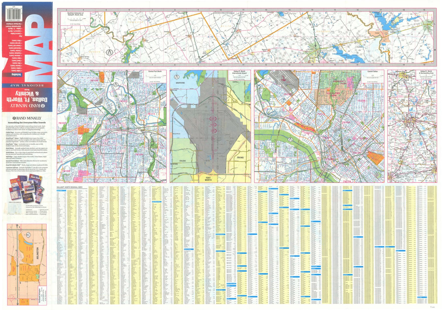
Dallas, Ft. Worth, & Vicinity, Texas - Regional Map
Northeast Arlington / Southern Extension of Dallas/Ft. Worth Area / Central Fort Worth / Dallas-Ft. Worth International Airport / Central Dallas / Dallas-Ft. Worth & Surrounding Area / Dallas-Ft. Worth Regional Index [verso]
-
Map/Doc
97289
-
Collection
General Map Collection
-
Object Dates
1997 (Creation Date)
-
People and Organizations
James Harkins (Donor)
Rand McNally (Publisher)
-
Subjects
City
-
Height x Width
25.7 x 36.7 inches
65.3 x 93.2 cm
-
Comments
Copyrighted map posted for research only. Unavailable for duplication.
For map on recto, please see map 97288.
Donated by James Harkins in July, 2024.
Related maps
Dallas, Ft. Worth, & Vicinity, Texas - Regional Map

Dallas, Ft. Worth, & Vicinity, Texas - Regional Map
1997
Size 25.9 x 36.7 inches
Map/Doc 97288
Part of: General Map Collection
Bastrop County Boundary File 2

Print $12.00
- Digital $50.00
Bastrop County Boundary File 2
Size 9.1 x 6.9 inches
Map/Doc 50315
Comanche County Sketch File 13

Print $4.00
- Digital $50.00
Comanche County Sketch File 13
Size 8.5 x 8.6 inches
Map/Doc 19076
McCulloch County Sketch File 13

Print $4.00
- Digital $50.00
McCulloch County Sketch File 13
1982
Size 3.4 x 7.8 inches
Map/Doc 31201

Pecos County Sketch File 101

Print $40.00
- Digital $50.00
Pecos County Sketch File 101
1960
Size 15.6 x 11.7 inches
Map/Doc 34012
Guadalupe County Sketch File 5a

Print $12.00
- Digital $50.00
Guadalupe County Sketch File 5a
1869
Size 12.6 x 8.0 inches
Map/Doc 42205
Van Zandt County Sketch File 32a

Print $4.00
- Digital $50.00
Van Zandt County Sketch File 32a
1860
Size 12.3 x 8.1 inches
Map/Doc 39467
Grayson County Sketch File 18

Print $6.00
- Digital $50.00
Grayson County Sketch File 18
1859
Size 12.2 x 7.9 inches
Map/Doc 24487
Flight Mission No. DQO-2K, Frame 148, Galveston County

Print $20.00
- Digital $50.00
Flight Mission No. DQO-2K, Frame 148, Galveston County
1952
Size 18.8 x 22.5 inches
Map/Doc 85045
Sutton County Sketch File 8

Print $20.00
- Digital $50.00
Sutton County Sketch File 8
1891
Size 24.9 x 31.6 inches
Map/Doc 12379
Flight Mission No. BRA-9M, Frame 59, Jefferson County

Print $20.00
- Digital $50.00
Flight Mission No. BRA-9M, Frame 59, Jefferson County
1953
Size 18.6 x 22.4 inches
Map/Doc 85642
Presidio County Rolled Sketch 57

Print $20.00
- Digital $50.00
Presidio County Rolled Sketch 57
1915
Size 22.8 x 17.3 inches
Map/Doc 7350
You may also like
Parker County Sketch File C

Print $4.00
- Digital $50.00
Parker County Sketch File C
1857
Size 6.1 x 7.8 inches
Map/Doc 33512
Tarrant County State Real Property Sketch 1

Print $60.00
- Digital $50.00
Tarrant County State Real Property Sketch 1
2007
Size 24.5 x 35.3 inches
Map/Doc 88666
Calhoun County Sketch File 20

Print $10.00
Calhoun County Sketch File 20
1839
Size 8.8 x 8.6 inches
Map/Doc 76865
Cherokee County Working Sketch 24

Print $20.00
- Digital $50.00
Cherokee County Working Sketch 24
1972
Size 37.2 x 38.8 inches
Map/Doc 67979
Flight Mission No. CRK-5P, Frame 160, Refugio County

Print $20.00
- Digital $50.00
Flight Mission No. CRK-5P, Frame 160, Refugio County
1956
Size 18.6 x 22.4 inches
Map/Doc 86941
Carte d'une partie de l'Amérique Séptentrionale, qui contient partie de la Nle. Espagne, et de la Louisiane

Print $20.00
- Digital $50.00
Carte d'une partie de l'Amérique Séptentrionale, qui contient partie de la Nle. Espagne, et de la Louisiane
1782
Size 14.1 x 18.5 inches
Map/Doc 94096
Lampasas County Working Sketch 22

Print $20.00
- Digital $50.00
Lampasas County Working Sketch 22
1993
Size 34.5 x 34.7 inches
Map/Doc 70300
Floyd County Working Sketch 11

Print $20.00
- Digital $50.00
Floyd County Working Sketch 11
1998
Size 23.0 x 34.1 inches
Map/Doc 69190
[Map of Texas and Pacific Blocks from Brazos River westward through Palo Pinto, Stephens, Shackelford, Jones, Callahan, Taylor, Fisher, Nolan and Mitchell Counties]
![93460, [Map of Texas and Pacific Blocks from Brazos River westward through Palo Pinto, Stephens, Shackelford, Jones, Callahan, Taylor, Fisher, Nolan and Mitchell Counties], General Map Collection](https://historictexasmaps.com/wmedia_w700/maps/93460.tif.jpg)
Print $40.00
- Digital $50.00
[Map of Texas and Pacific Blocks from Brazos River westward through Palo Pinto, Stephens, Shackelford, Jones, Callahan, Taylor, Fisher, Nolan and Mitchell Counties]
Size 87.1 x 18.8 inches
Map/Doc 93460
Galveston Bay and Approaches

Print $20.00
- Digital $50.00
Galveston Bay and Approaches
1924
Size 45.5 x 34.0 inches
Map/Doc 69873
Uvalde County Working Sketch 31

Print $20.00
- Digital $50.00
Uvalde County Working Sketch 31
1962
Size 28.5 x 43.0 inches
Map/Doc 72101
Plat showing proposed Water Permit on Cow Bayou in Orange County, Texas

Print $20.00
- Digital $50.00
Plat showing proposed Water Permit on Cow Bayou in Orange County, Texas
1922
Size 24.3 x 16.4 inches
Map/Doc 93017