Wood County Rolled Sketch 4
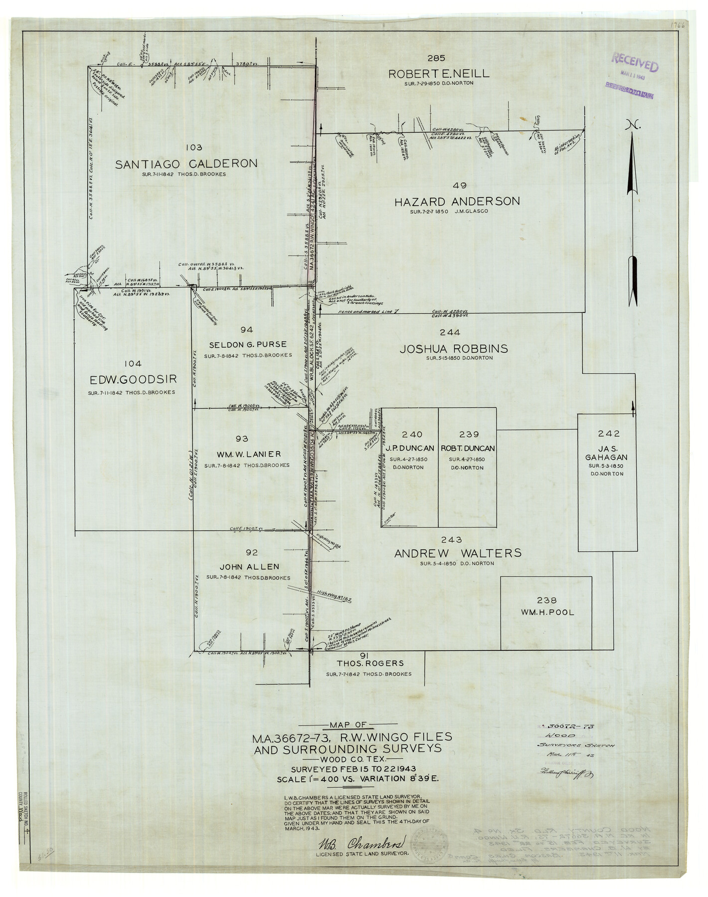
Map of M.A. 36672-73, R.W. Wingo files and surrounding surveys, Wood Co., Tex.
-
Map/Doc
8283
-
Collection
General Map Collection
-
Object Dates
1943/2/22 (Survey Date)
1943/3/11 (File Date)
1943/3/4 (Creation Date)
-
People and Organizations
W.B. Chambers (Surveyor/Engineer)
-
Counties
Wood
-
Subjects
Surveying Rolled Sketch
-
Height x Width
37.0 x 29.2 inches
94.0 x 74.2 cm
-
Medium
linen, manuscript
-
Scale
1" = 400 varas
Part of: General Map Collection
Jim Hogg Co. / Brooks Co.

Print $20.00
- Digital $50.00
Jim Hogg Co. / Brooks Co.
1912
Size 33.0 x 43.6 inches
Map/Doc 4894
Upton County Working Sketch 1

Print $20.00
- Digital $50.00
Upton County Working Sketch 1
1906
Size 11.6 x 20.0 inches
Map/Doc 69497
Burnet County Sketch File 4

Print $4.00
- Digital $50.00
Burnet County Sketch File 4
1860
Size 8.2 x 7.9 inches
Map/Doc 16676
United States, 1956 Revised Edition

Print $40.00
- Digital $50.00
United States, 1956 Revised Edition
1946
Size 48.0 x 36.3 inches
Map/Doc 78631
McMullen County Working Sketch 62

Print $20.00
- Digital $50.00
McMullen County Working Sketch 62
2016
Size 24.1 x 36.1 inches
Map/Doc 94089
Flight Mission No. DIX-8P, Frame 95, Aransas County

Print $20.00
- Digital $50.00
Flight Mission No. DIX-8P, Frame 95, Aransas County
1956
Size 18.4 x 22.3 inches
Map/Doc 83920
Bell County Sketch File 24

Print $4.00
- Digital $50.00
Bell County Sketch File 24
Size 10.0 x 8.0 inches
Map/Doc 14418

Panola County Sketch File 28

Print $20.00
- Digital $50.00
Panola County Sketch File 28
1859
Size 22.8 x 22.2 inches
Map/Doc 12142
Trinity River, Wire Bridge Sheet/Denton Creek

Print $6.00
- Digital $50.00
Trinity River, Wire Bridge Sheet/Denton Creek
1938
Size 30.4 x 29.7 inches
Map/Doc 65244
Maps of Gulf Intracoastal Waterway, Texas - Sabine River to the Rio Grande and connecting waterways including ship channels

Print $20.00
- Digital $50.00
Maps of Gulf Intracoastal Waterway, Texas - Sabine River to the Rio Grande and connecting waterways including ship channels
1966
Size 14.6 x 22.3 inches
Map/Doc 61954
Flight Mission No. BRE-1P, Frame 75, Nueces County

Print $20.00
- Digital $50.00
Flight Mission No. BRE-1P, Frame 75, Nueces County
1956
Size 18.4 x 22.2 inches
Map/Doc 86657
You may also like

Roberts County Sketch File 2

Print $6.00
- Digital $50.00
Roberts County Sketch File 2
1882
Size 12.8 x 8.0 inches
Map/Doc 35303
Wise County Working Sketch 12

Print $20.00
- Digital $50.00
Wise County Working Sketch 12
1958
Size 23.0 x 29.6 inches
Map/Doc 72626
Lynn County Boundary File 7

Print $10.00
- Digital $50.00
Lynn County Boundary File 7
Size 11.5 x 8.8 inches
Map/Doc 56642
Bexar County Rolled Sketch 3

Print $20.00
- Digital $50.00
Bexar County Rolled Sketch 3
1873
Size 25.5 x 18.0 inches
Map/Doc 5136
Smith's Atlas designed to accompany the Geography

Print $352.00
- Digital $50.00
Smith's Atlas designed to accompany the Geography
1850
Size 12.2 x 10.0 inches
Map/Doc 93881
[I. M. Bolton, L. S. Thacker, and R. C. Poteet Subdivisions]
![92578, [I. M. Bolton, L. S. Thacker, and R. C. Poteet Subdivisions], Twichell Survey Records](https://historictexasmaps.com/wmedia_w700/maps/92578-1.tif.jpg)
Print $20.00
- Digital $50.00
[I. M. Bolton, L. S. Thacker, and R. C. Poteet Subdivisions]
1924
Size 18.7 x 24.7 inches
Map/Doc 92578
Sketch of surveys in Shelby Co.

Print $2.00
- Digital $50.00
Sketch of surveys in Shelby Co.
1845
Size 6.4 x 8.8 inches
Map/Doc 69741
Wheeler County Sketch File 3

Print $24.00
- Digital $50.00
Wheeler County Sketch File 3
1881
Size 12.9 x 8.4 inches
Map/Doc 39998
Working Sketch in Pecos Co. [now Val Verde and Terrell Counties] / [Connecting Lines]
![91945, Working Sketch in Pecos Co. [now Val Verde and Terrell Counties] / [Connecting Lines], Twichell Survey Records](https://historictexasmaps.com/wmedia_w700/maps/91945-1.tif.jpg)
Print $20.00
- Digital $50.00
Working Sketch in Pecos Co. [now Val Verde and Terrell Counties] / [Connecting Lines]
Size 29.6 x 21.8 inches
Map/Doc 91945
Neches River, Blackburn Bridge Sheet

Print $4.00
- Digital $50.00
Neches River, Blackburn Bridge Sheet
1938
Size 27.6 x 20.5 inches
Map/Doc 65083
[Surveys between Big Keechi Creek and the Trinity River]
![69753, [Surveys between Big Keechi Creek and the Trinity River], General Map Collection](https://historictexasmaps.com/wmedia_w700/maps/69753.tif.jpg)
Print $2.00
- Digital $50.00
[Surveys between Big Keechi Creek and the Trinity River]
Size 10.1 x 7.3 inches
Map/Doc 69753