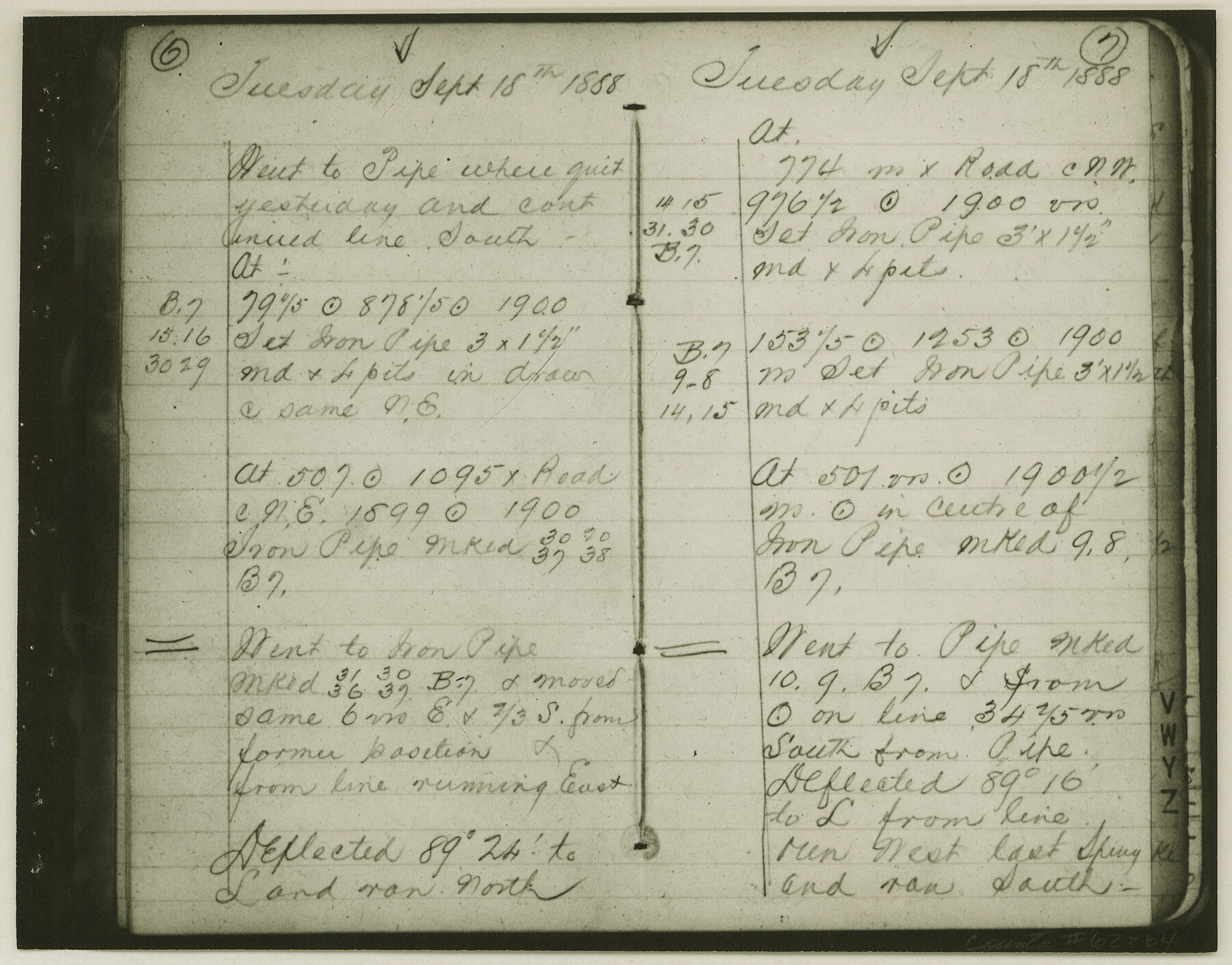
Copy of Surveyor's Field Book, Morris Browning - In Blocks 7, 5 & 4, I&GNRRCo., Hutchinson and Carson Counties, Texas
K-7-70
-
Map/Doc
62264
-
Collection
General Map Collection
-
Object Dates
1888/10/22 (Creation Date)
-
People and Organizations
Morris Browning (Surveyor/Engineer)
-
Counties
Hutchinson Carson
-
Height x Width
6.9 x 8.8 inches
17.5 x 22.4 cm
-
Comments
Copy of Surveyor's field book presented to the General Land Office by Morris Browning on February 3, 1941.
Surveyed from September 14, 1888 to October 22, 1888.
Part of: General Map Collection
Baylor County Rolled Sketch 10

Print $20.00
- Digital $50.00
Baylor County Rolled Sketch 10
Size 28.0 x 14.0 inches
Map/Doc 5127
Flight Mission No. DAG-23K, Frame 14, Matagorda County

Print $20.00
- Digital $50.00
Flight Mission No. DAG-23K, Frame 14, Matagorda County
1953
Size 15.6 x 15.5 inches
Map/Doc 86476
Harris County Sketch File 26

Print $8.00
- Digital $50.00
Harris County Sketch File 26
Size 9.2 x 8.5 inches
Map/Doc 25393
Mustang Island

Print $20.00
- Digital $50.00
Mustang Island
1945
Size 42.8 x 42.6 inches
Map/Doc 77469
Nautical Chart 887-SC Intracoastal Waterway - Galveston Bay to Cedar Lakes including the Brazos and San Bernard Rivers, Texas

Print $20.00
- Digital $50.00
Nautical Chart 887-SC Intracoastal Waterway - Galveston Bay to Cedar Lakes including the Brazos and San Bernard Rivers, Texas
1971
Size 16.2 x 18.9 inches
Map/Doc 75911
Flight Mission No. DCL-7C, Frame 136, Kenedy County

Print $20.00
- Digital $50.00
Flight Mission No. DCL-7C, Frame 136, Kenedy County
1943
Size 18.6 x 22.3 inches
Map/Doc 86093
Flight Mission No. CRC-5R, Frame 26, Chambers County

Print $20.00
- Digital $50.00
Flight Mission No. CRC-5R, Frame 26, Chambers County
1956
Size 18.6 x 22.5 inches
Map/Doc 84948
Bexar County Sketch File 14

Print $4.00
- Digital $50.00
Bexar County Sketch File 14
1855
Size 7.8 x 8.2 inches
Map/Doc 14482
[Galveston, Harrisburg & San Antonio Railroad from Cuero to Stockdale]
![64199, [Galveston, Harrisburg & San Antonio Railroad from Cuero to Stockdale], General Map Collection](https://historictexasmaps.com/wmedia_w700/maps/64199.tif.jpg)
Print $20.00
- Digital $50.00
[Galveston, Harrisburg & San Antonio Railroad from Cuero to Stockdale]
1907
Size 12.9 x 33.2 inches
Map/Doc 64199
Sketch D No. 2 Showing the Progress of the Survey of Cape Fear and Vicinity in Sections No. IV & V

Digital $50.00
Sketch D No. 2 Showing the Progress of the Survey of Cape Fear and Vicinity in Sections No. IV & V
1852
Size 12.3 x 10.0 inches
Map/Doc 97209
Flight Mission No. BRE-2P, Frame 13, Nueces County

Print $20.00
- Digital $50.00
Flight Mission No. BRE-2P, Frame 13, Nueces County
1956
Size 18.0 x 22.1 inches
Map/Doc 86722
La Salle County Sketch File 33

Print $2.00
- Digital $50.00
La Salle County Sketch File 33
1875
Size 13.4 x 8.0 inches
Map/Doc 29584
You may also like
Intracoastal Waterway in Texas - Corpus Christi to Point Isabel including Arroyo Colorado to Mo. Pac. R.R. Bridge Near Harlingen

Print $20.00
- Digital $50.00
Intracoastal Waterway in Texas - Corpus Christi to Point Isabel including Arroyo Colorado to Mo. Pac. R.R. Bridge Near Harlingen
1933
Size 28.0 x 40.8 inches
Map/Doc 61850
Floyd County Rolled Sketch 5

Print $20.00
- Digital $50.00
Floyd County Rolled Sketch 5
1892
Size 27.2 x 18.7 inches
Map/Doc 5880
Flight Mission No. BRA-16M, Frame 101, Jefferson County

Print $20.00
- Digital $50.00
Flight Mission No. BRA-16M, Frame 101, Jefferson County
1953
Size 18.6 x 22.4 inches
Map/Doc 85713
Map of Webb County

Print $20.00
- Digital $50.00
Map of Webb County
1878
Size 37.0 x 26.0 inches
Map/Doc 4130
[Maps of surveys in Reeves & Culberson Cos]
![61144, [Maps of surveys in Reeves & Culberson Cos], General Map Collection](https://historictexasmaps.com/wmedia_w700/maps/61144.tif.jpg)
Print $20.00
- Digital $50.00
[Maps of surveys in Reeves & Culberson Cos]
1937
Size 30.9 x 25.1 inches
Map/Doc 61144
Trinity County Sketch File 23

Print $26.00
- Digital $50.00
Trinity County Sketch File 23
1861
Size 6.9 x 8.3 inches
Map/Doc 38552
Andrews County Sketch File 6

Print $9.00
- Digital $50.00
Andrews County Sketch File 6
1942
Size 9.6 x 10.6 inches
Map/Doc 12825
Hays County Rolled Sketch 25

Print $20.00
- Digital $50.00
Hays County Rolled Sketch 25
1925
Size 17.5 x 40.0 inches
Map/Doc 6181
Galveston County NRC Article 33.136 Sketch 18

Print $66.00
- Digital $50.00
Galveston County NRC Article 33.136 Sketch 18
2003
Size 22.4 x 33.9 inches
Map/Doc 78545
Pecos County Working Sketch Graphic Index - northeast part - sheet A

Print $20.00
- Digital $50.00
Pecos County Working Sketch Graphic Index - northeast part - sheet A
1975
Size 35.8 x 42.6 inches
Map/Doc 76666
History of Texas from its First Settlement in 1685 to its Annexation to the United States in 1846 (Vol. 2)

History of Texas from its First Settlement in 1685 to its Annexation to the United States in 1846 (Vol. 2)
1856
Map/Doc 97391
Callahan County Sketch File 7

Print $18.00
- Digital $50.00
Callahan County Sketch File 7
Size 10.8 x 8.9 inches
Map/Doc 35863