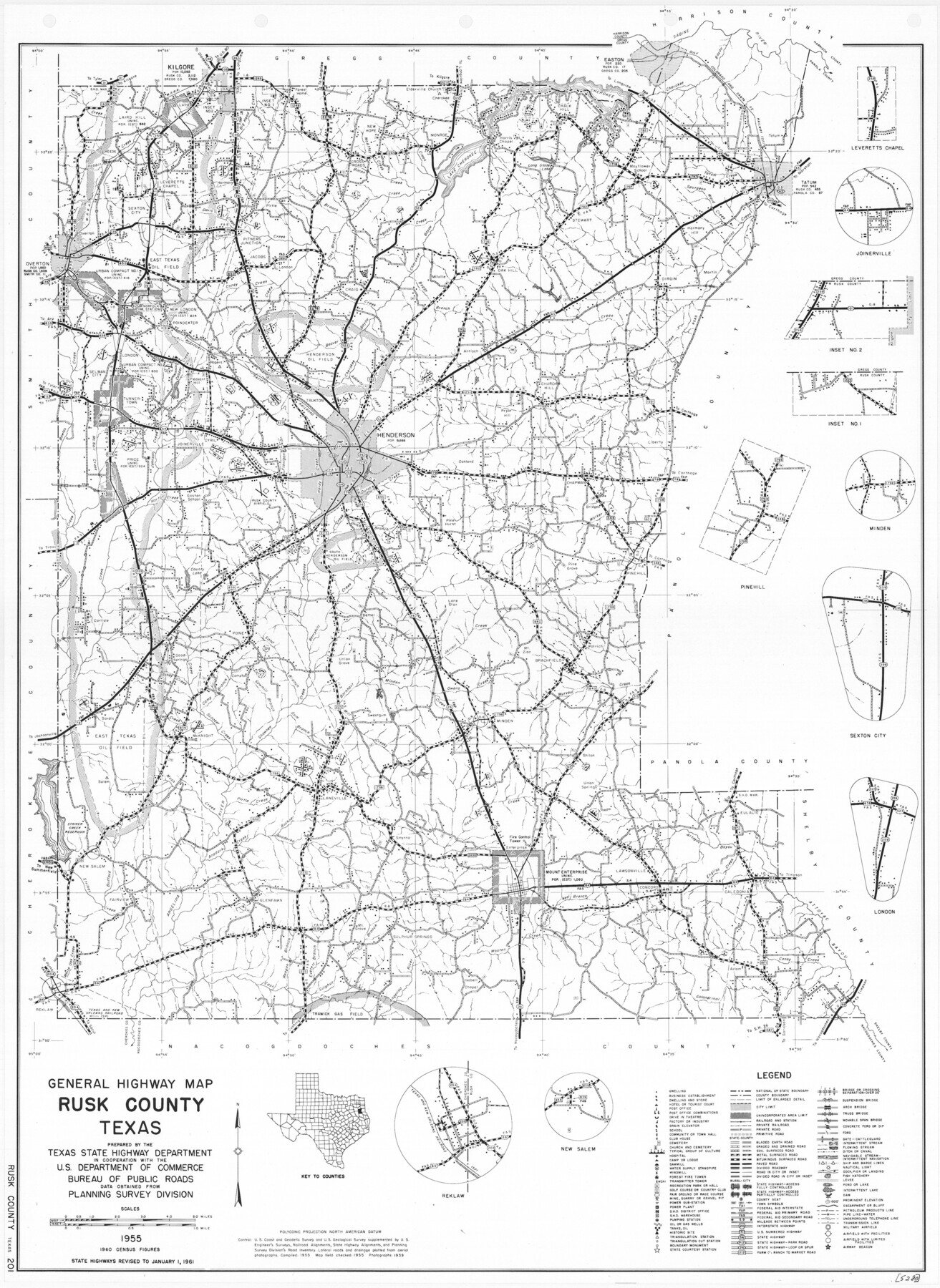
General Highway Map, Rusk County, Texas
-
Map/Doc
79643
-
Collection
Texas State Library and Archives
-
Object Dates
1961 (Creation Date)
-
People and Organizations
Texas State Highway Department (Publisher)
-
Counties
Rusk
-
Subjects
County
-
Height x Width
24.9 x 18.2 inches
63.3 x 46.2 cm
-
Comments
Prints available courtesy of the Texas State Library and Archives.
More info can be found here: TSLAC Map 05280
Part of: Texas State Library and Archives
General Highway Map, Hutchinson County, Texas

Print $20.00
General Highway Map, Hutchinson County, Texas
1961
Size 18.1 x 24.6 inches
Map/Doc 79529
General Highway Map, Travis County, Texas

Print $20.00
General Highway Map, Travis County, Texas
1961
Size 18.2 x 24.7 inches
Map/Doc 79680
Railroad and County Map of Texas

Print $20.00
Railroad and County Map of Texas
1901
Size 33.1 x 37.1 inches
Map/Doc 76213
General Highway Map, Reeves County, Texas

Print $20.00
General Highway Map, Reeves County, Texas
1940
Size 24.8 x 18.2 inches
Map/Doc 79227
Map of Texas, compiled from surveys on record in the General Land Office of the Republic

Print $20.00
Map of Texas, compiled from surveys on record in the General Land Office of the Republic
1847
Size 32.2 x 25.0 inches
Map/Doc 79325
New Commercial Map of Texas

Print $20.00
New Commercial Map of Texas
1900
Size 28.1 x 34.0 inches
Map/Doc 76199
Map of the Country Upon Upper Red River Explored in 1852

Print $20.00
Map of the Country Upon Upper Red River Explored in 1852
1852
Size 17.2 x 34.9 inches
Map/Doc 79726
Rand McNally Standard Map of Texas (reverse)

Print $20.00
Rand McNally Standard Map of Texas (reverse)
1923
Size 39.8 x 27.2 inches
Map/Doc 76229
General Highway Map, Nueces County, Texas

Print $20.00
General Highway Map, Nueces County, Texas
1940
Size 24.6 x 18.4 inches
Map/Doc 79210
General Highway Map, Hamilton County, Texas

Print $20.00
General Highway Map, Hamilton County, Texas
1961
Size 18.1 x 24.9 inches
Map/Doc 79496
General Highway Map, Delta County, Hopkins County, Texas

Print $20.00
General Highway Map, Delta County, Hopkins County, Texas
1961
Size 24.6 x 18.2 inches
Map/Doc 79439
General Highway Map, Nolan County, Texas

Print $20.00
General Highway Map, Nolan County, Texas
1940
Size 18.4 x 24.7 inches
Map/Doc 79208
You may also like
Scurry County Rolled Sketch 7

Print $20.00
- Digital $50.00
Scurry County Rolled Sketch 7
1946
Size 23.5 x 10.4 inches
Map/Doc 7767
Milam County Working Sketch Graphic Index

Print $40.00
- Digital $50.00
Milam County Working Sketch Graphic Index
1975
Size 51.6 x 42.7 inches
Map/Doc 76642
Hockley County Rolled Sketch 6

Print $40.00
- Digital $50.00
Hockley County Rolled Sketch 6
Size 30.6 x 48.2 inches
Map/Doc 6216
[Galveston, Harrisburg & San Antonio through El Paso County]
![64006, [Galveston, Harrisburg & San Antonio through El Paso County], General Map Collection](https://historictexasmaps.com/wmedia_w700/maps/64006.tif.jpg)
Print $20.00
- Digital $50.00
[Galveston, Harrisburg & San Antonio through El Paso County]
Size 13.5 x 33.7 inches
Map/Doc 64006
Chambers County Sketch File 52

Print $8.00
- Digital $50.00
Chambers County Sketch File 52
1839
Size 13.0 x 8.3 inches
Map/Doc 18083
America's Fun-Tier: Texas 1966 Official State Highway Map

Digital $50.00
America's Fun-Tier: Texas 1966 Official State Highway Map
Size 28.2 x 36.5 inches
Map/Doc 94324
Harris County Rolled Sketch 91

Print $407.00
- Digital $50.00
Harris County Rolled Sketch 91
1981
Size 31.0 x 24.3 inches
Map/Doc 6130
Tyler County Rolled Sketch 11

Print $20.00
- Digital $50.00
Tyler County Rolled Sketch 11
Size 34.2 x 36.4 inches
Map/Doc 10033
Sulphur River, Bassett Sheet

Print $20.00
- Digital $50.00
Sulphur River, Bassett Sheet
1939
Size 25.3 x 32.0 inches
Map/Doc 78320

Flight Mission No. DAG-17K, Frame 61, Matagorda County

Print $20.00
- Digital $50.00
Flight Mission No. DAG-17K, Frame 61, Matagorda County
1952
Size 16.4 x 16.4 inches
Map/Doc 86323
Flight Mission No. CRK-5P, Frame 129, Refugio County

Print $20.00
- Digital $50.00
Flight Mission No. CRK-5P, Frame 129, Refugio County
1956
Size 18.4 x 22.3 inches
Map/Doc 86932