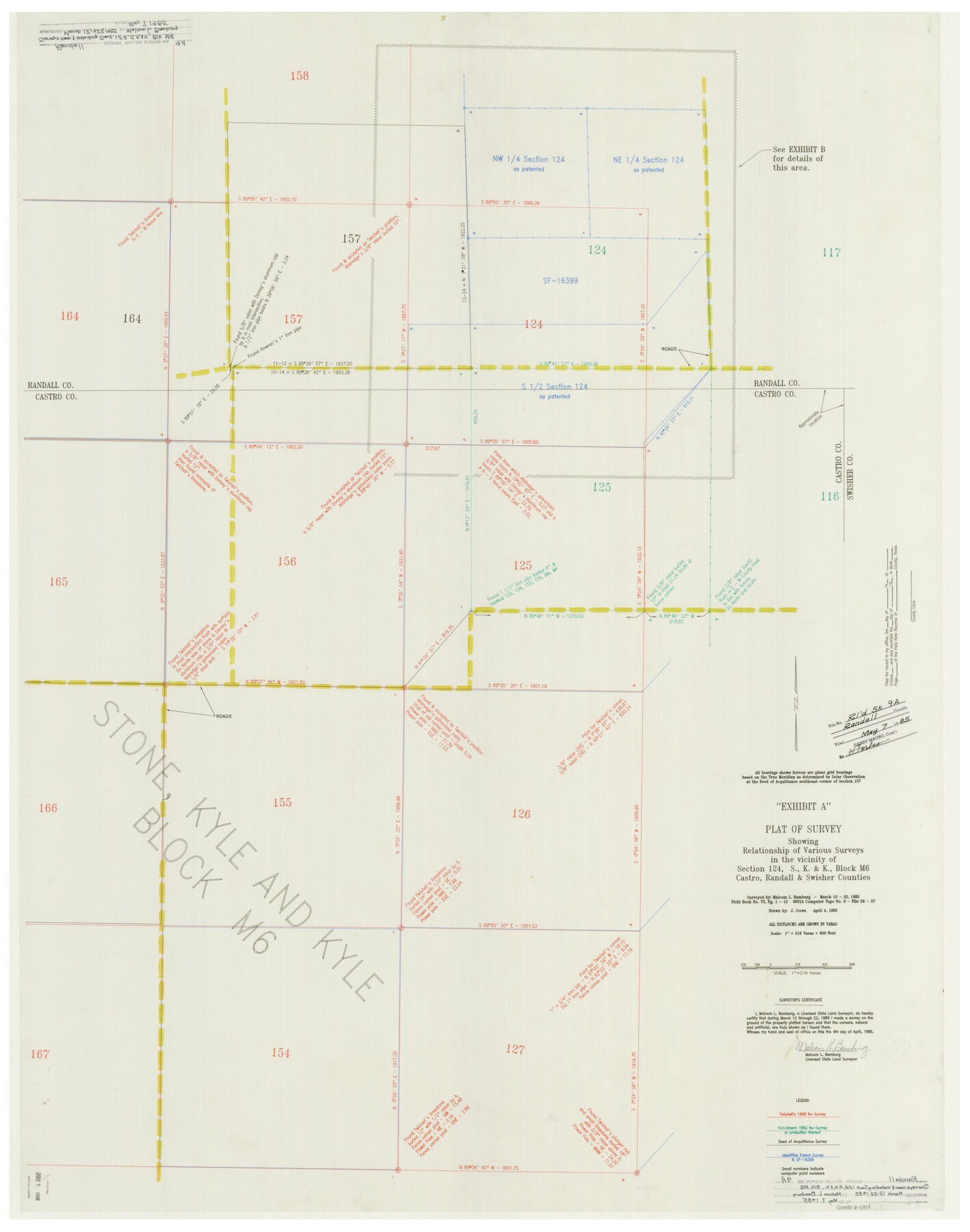
Randall County Rolled Sketch 9A
"Exhibit A" - Plat of survey showing relationship of various surveys in the vicinity of section 124, S. K. & K. Block M6, Castro, Randall, & Swisher Counties
-
Map/Doc
10314
-
Collection
General Map Collection
-
Object Dates
1985/4/4 (Creation Date)
1985/5/7 (File Date)
1985/3/22 (Survey Date)
-
People and Organizations
Malcom L. Bamburg (Surveyor/Engineer)
J. Crews (Draftsman)
-
Counties
Randall Castro Swisher
-
Subjects
Surveying Rolled Sketch
-
Height x Width
44.5 x 35.0 inches
113.0 x 88.9 cm
-
Medium
mylar, print
-
Scale
1" = 216 varas
Part of: General Map Collection
Culberson County Rolled Sketch 52

Print $20.00
- Digital $50.00
Culberson County Rolled Sketch 52
Size 19.1 x 24.7 inches
Map/Doc 5672
Atascosa County Rolled Sketch 5B2

Print $20.00
- Digital $50.00
Atascosa County Rolled Sketch 5B2
1910
Size 16.4 x 12.5 inches
Map/Doc 5091
Flight Mission No. DAG-28K, Frame 27, Matagorda County

Print $20.00
- Digital $50.00
Flight Mission No. DAG-28K, Frame 27, Matagorda County
1953
Size 16.2 x 16.1 inches
Map/Doc 86595
Young County Sketch File 17

Print $20.00
- Digital $50.00
Young County Sketch File 17
Size 18.5 x 24.3 inches
Map/Doc 12713
United States - Gulf Coast - Galveston to Rio Grande

Print $20.00
- Digital $50.00
United States - Gulf Coast - Galveston to Rio Grande
1919
Size 27.1 x 18.3 inches
Map/Doc 72745
Right of Way and Track Map, Dayton-Goose Creek Ry. Co., Station 190+00 to Station 401+20

Print $40.00
- Digital $50.00
Right of Way and Track Map, Dayton-Goose Creek Ry. Co., Station 190+00 to Station 401+20
1917
Size 25.4 x 56.8 inches
Map/Doc 64366
Flight Mission No. DQO-3K, Frame 16, Galveston County

Print $20.00
- Digital $50.00
Flight Mission No. DQO-3K, Frame 16, Galveston County
1952
Size 18.9 x 22.5 inches
Map/Doc 85057
Flight Mission No. CLL-1N, Frame 84, Willacy County

Print $20.00
- Digital $50.00
Flight Mission No. CLL-1N, Frame 84, Willacy County
1954
Size 18.5 x 22.2 inches
Map/Doc 87030
Cottle County Working Sketch 8

Print $20.00
- Digital $50.00
Cottle County Working Sketch 8
1917
Size 26.9 x 29.7 inches
Map/Doc 68318
Kinney County Working Sketch 59

Print $20.00
- Digital $50.00
Kinney County Working Sketch 59
1999
Size 19.9 x 24.8 inches
Map/Doc 70241
Martin County Boundary File 2

Print $32.00
- Digital $50.00
Martin County Boundary File 2
Size 9.3 x 9.1 inches
Map/Doc 56760
Cherokee County Sketch File 27

Print $4.00
- Digital $50.00
Cherokee County Sketch File 27
1852
Size 8.3 x 8.2 inches
Map/Doc 18171
You may also like
San Saba County Sketch File 1

Print $46.00
- Digital $50.00
San Saba County Sketch File 1
1854
Size 9.1 x 7.8 inches
Map/Doc 36400
Map of Texas with Parts of the Adjoining States

Print $20.00
- Digital $50.00
Map of Texas with Parts of the Adjoining States
1837
Size 31.5 x 24.9 inches
Map/Doc 2114
Jack County Sketch File 14

Print $8.00
- Digital $50.00
Jack County Sketch File 14
1857
Size 10.0 x 5.7 inches
Map/Doc 27539
Archer County Working Sketch 16

Print $20.00
- Digital $50.00
Archer County Working Sketch 16
1939
Size 10.9 x 17.8 inches
Map/Doc 67157

Callahan County Working Sketch 11

Print $40.00
- Digital $50.00
Callahan County Working Sketch 11
1978
Size 43.0 x 48.1 inches
Map/Doc 67893

Rough Working Sketch in Moore County

Print $20.00
- Digital $50.00
Rough Working Sketch in Moore County
Size 13.2 x 24.1 inches
Map/Doc 91414
[Township 3 North, Block 31]
![91217, [Township 3 North, Block 31], Twichell Survey Records](https://historictexasmaps.com/wmedia_w700/maps/91217-1.tif.jpg)
Print $3.00
- Digital $50.00
[Township 3 North, Block 31]
Size 11.6 x 13.4 inches
Map/Doc 91217
Carte de la Louisiane cours du Mississipi et pais voisins dediée à M. le Comte de Maurepas, Ministre et Secretaire d'Etat Commandeur des Ordres du Roy

Print $20.00
- Digital $50.00
Carte de la Louisiane cours du Mississipi et pais voisins dediée à M. le Comte de Maurepas, Ministre et Secretaire d'Etat Commandeur des Ordres du Roy
1744
Size 17.5 x 23.3 inches
Map/Doc 94496
[Corpus Christi Bay, Padre Island, Mustang Island, Laguna de la Madre, King and Kenedy's Pasture]
![73040, [Corpus Christi Bay, Padre Island, Mustang Island, Laguna de la Madre, King and Kenedy's Pasture], General Map Collection](https://historictexasmaps.com/wmedia_w700/maps/73040.tif.jpg)
Print $20.00
- Digital $50.00
[Corpus Christi Bay, Padre Island, Mustang Island, Laguna de la Madre, King and Kenedy's Pasture]
Size 18.2 x 27.0 inches
Map/Doc 73040
Brazos River, Washington Sheet

Print $6.00
- Digital $50.00
Brazos River, Washington Sheet
1936
Size 30.4 x 24.7 inches
Map/Doc 65277