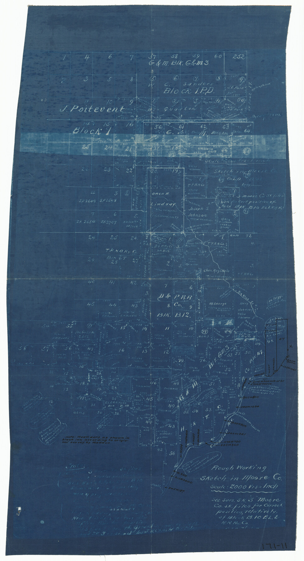
Rough Working Sketch in Moore County
171-11
-
Map/Doc
91414
-
Collection
Twichell Survey Records
-
Counties
Moore
-
Height x Width
13.2 x 24.1 inches
33.5 x 61.2 cm
Part of: Twichell Survey Records
[McLennan County School Land Leagues 3 and 4 and surrounding surveys/blocks]
![90434, [McLennan County School Land Leagues 3 and 4 and surrounding surveys/blocks], Twichell Survey Records](https://historictexasmaps.com/wmedia_w700/maps/90434-1.tif.jpg)
Print $20.00
- Digital $50.00
[McLennan County School Land Leagues 3 and 4 and surrounding surveys/blocks]
Size 12.0 x 14.8 inches
Map/Doc 90434
[E. T. Ry. Blk. 1]
![89794, [E. T. Ry. Blk. 1], Twichell Survey Records](https://historictexasmaps.com/wmedia_w700/maps/89794-1.tif.jpg)
Print $40.00
- Digital $50.00
[E. T. Ry. Blk. 1]
Size 56.5 x 43.4 inches
Map/Doc 89794
The Great Lakes Region of the United States and Canada

The Great Lakes Region of the United States and Canada
1953
Size 42.5 x 28.6 inches
Map/Doc 92396
[Sketch Between Collingsworth County and Oklahoma]
![89663, [Sketch Between Collingsworth County and Oklahoma], Twichell Survey Records](https://historictexasmaps.com/wmedia_w700/maps/89663-1.tif.jpg)
Print $40.00
- Digital $50.00
[Sketch Between Collingsworth County and Oklahoma]
Size 9.4 x 62.5 inches
Map/Doc 89663
[Sketch of part of G. & M. Block 5]
![93073, [Sketch of part of G. & M. Block 5], Twichell Survey Records](https://historictexasmaps.com/wmedia_w700/maps/93073-1.tif.jpg)
Print $2.00
- Digital $50.00
[Sketch of part of G. & M. Block 5]
Size 6.7 x 8.7 inches
Map/Doc 93073
Witt Addition, Subdivision out of Section 6, Block E, City of Lubbock

Print $20.00
- Digital $50.00
Witt Addition, Subdivision out of Section 6, Block E, City of Lubbock
1950
Size 9.5 x 31.4 inches
Map/Doc 92738
Map of Capitol Syndicate Subdivisions of Capitol Land Reservation Leagues

Print $40.00
- Digital $50.00
Map of Capitol Syndicate Subdivisions of Capitol Land Reservation Leagues
1906
Size 44.6 x 72.6 inches
Map/Doc 93131
Ownership Map NW 1/4 Lubbock County

Print $20.00
- Digital $50.00
Ownership Map NW 1/4 Lubbock County
1926
Size 32.1 x 39.6 inches
Map/Doc 89696
San Augustine County School Land for sale by Lubbock Irrigation Company

Print $20.00
- Digital $50.00
San Augustine County School Land for sale by Lubbock Irrigation Company
Size 23.4 x 24.8 inches
Map/Doc 92826
[Surveys South of Levi Pruitt]
![92092, [Surveys South of Levi Pruitt], Twichell Survey Records](https://historictexasmaps.com/wmedia_w700/maps/92092-1.tif.jpg)
Print $3.00
- Digital $50.00
[Surveys South of Levi Pruitt]
1924
Size 11.3 x 11.6 inches
Map/Doc 92092
[T. & N. O. RR. Block 1T]
![91902, [T. & N. O. RR. Block 1T], Twichell Survey Records](https://historictexasmaps.com/wmedia_w700/maps/91902-1.tif.jpg)
Print $20.00
- Digital $50.00
[T. & N. O. RR. Block 1T]
Size 14.9 x 20.0 inches
Map/Doc 91902
Wheelock's Second Addit(ion)

Print $20.00
- Digital $50.00
Wheelock's Second Addit(ion)
Size 31.5 x 32.3 inches
Map/Doc 92820
You may also like
Flight Mission No. DQN-1K, Frame 80, Calhoun County

Print $20.00
- Digital $50.00
Flight Mission No. DQN-1K, Frame 80, Calhoun County
1953
Size 18.4 x 22.1 inches
Map/Doc 84165
Edwards County Working Sketch 115

Print $20.00
- Digital $50.00
Edwards County Working Sketch 115
1973
Size 39.6 x 43.9 inches
Map/Doc 68991
'The Cradle of Texas' - San Augustine

Print $20.00
- Digital $50.00
'The Cradle of Texas' - San Augustine
Size 19.3 x 25.3 inches
Map/Doc 94441
Maps & Lists Showing Prison Lands (Oil & Gas) Leased as of June 1955

Digital $50.00
Maps & Lists Showing Prison Lands (Oil & Gas) Leased as of June 1955
Size 8.7 x 11.2 inches
Map/Doc 62869
Bosque County Sketch File 8

Print $4.00
- Digital $50.00
Bosque County Sketch File 8
1858
Size 12.4 x 8.2 inches
Map/Doc 14752
Uvalde County Rolled Sketch 22

Print $20.00
- Digital $50.00
Uvalde County Rolled Sketch 22
2002
Size 30.4 x 41.0 inches
Map/Doc 78656
Flight Mission No. BQR-5K, Frame 68, Brazoria County

Print $20.00
- Digital $50.00
Flight Mission No. BQR-5K, Frame 68, Brazoria County
1952
Size 18.8 x 22.5 inches
Map/Doc 84013
Flight Mission No. DAG-26K, Frame 81, Matagorda County

Print $20.00
- Digital $50.00
Flight Mission No. DAG-26K, Frame 81, Matagorda County
1953
Size 18.5 x 22.2 inches
Map/Doc 86586
Henderson County Sketch File 2

Print $20.00
- Digital $50.00
Henderson County Sketch File 2
1850
Size 21.6 x 17.1 inches
Map/Doc 11755
G. W. Cochran Farm Section 32, Block JS

Print $20.00
- Digital $50.00
G. W. Cochran Farm Section 32, Block JS
1943
Size 12.6 x 23.4 inches
Map/Doc 92328
San Patricio County Working Sketch 24
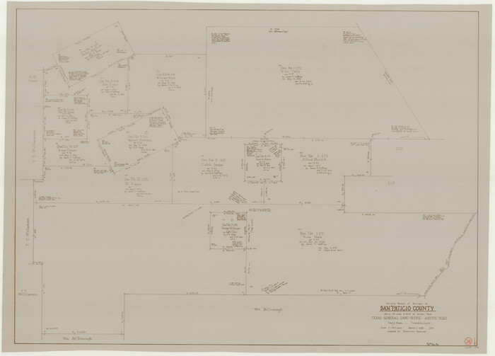
Print $20.00
- Digital $50.00
San Patricio County Working Sketch 24
1988
Size 30.9 x 43.0 inches
Map/Doc 63786
Young Land District

Print $20.00
- Digital $50.00
Young Land District
1857
Size 21.7 x 29.7 inches
Map/Doc 1974