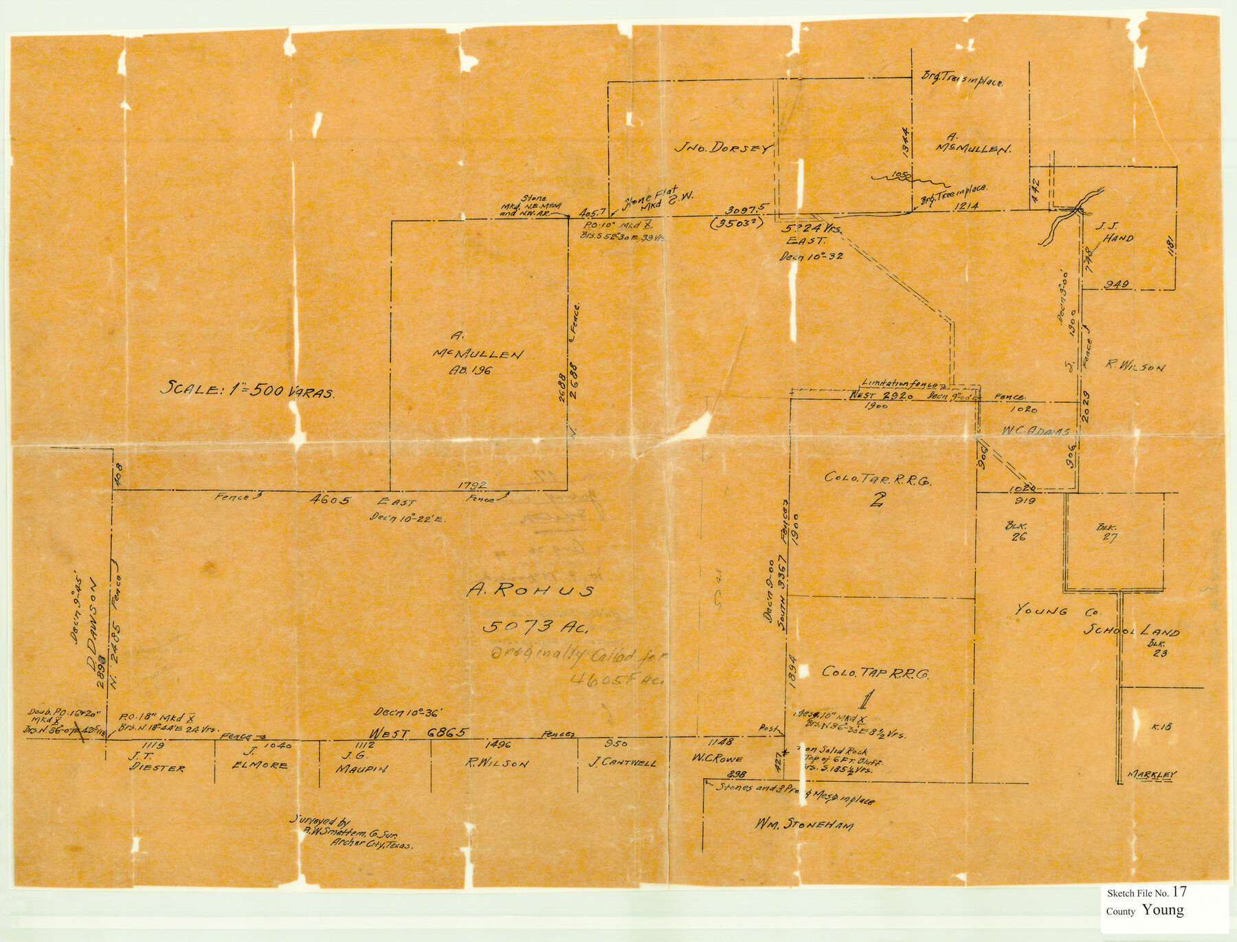
Young County Sketch File 17
B. W. Smitten's sk. of the A. Rohus sur.
-
Map/Doc
12713
-
Collection
General Map Collection
-
Object Dates
1929/8/26 (File Date)
-
People and Organizations
B.W. Smettem (Surveyor/Engineer)
-
Counties
Young
-
Subjects
Surveying Sketch File
-
Height x Width
18.5 x 24.3 inches
47.0 x 61.7 cm
-
Medium
paper, manuscript
Part of: General Map Collection
Flight Mission No. BQR-22K, Frame 39, Brazoria County

Print $20.00
- Digital $50.00
Flight Mission No. BQR-22K, Frame 39, Brazoria County
1953
Size 18.8 x 22.4 inches
Map/Doc 84123
Township 8 North Range 14 West, North Western District, Louisiana

Print $20.00
- Digital $50.00
Township 8 North Range 14 West, North Western District, Louisiana
1854
Size 19.7 x 24.7 inches
Map/Doc 65874
El Paso County Sketch File 35 (2)

Print $18.00
- Digital $50.00
El Paso County Sketch File 35 (2)
1886
Size 12.9 x 8.3 inches
Map/Doc 22170
Map of the Western Territory &c.

Print $20.00
- Digital $50.00
Map of the Western Territory &c.
Size 18.5 x 18.8 inches
Map/Doc 95691
Tom Green County Sketch File 46 1/2

Print $40.00
- Digital $50.00
Tom Green County Sketch File 46 1/2
1882
Size 12.7 x 19.6 inches
Map/Doc 12440
Callahan County Boundary File 1

Print $120.00
- Digital $50.00
Callahan County Boundary File 1
Size 14.2 x 8.6 inches
Map/Doc 51025
Bandera County Sketch File 22

Print $4.00
- Digital $50.00
Bandera County Sketch File 22
Size 12.6 x 7.9 inches
Map/Doc 14012
Webb County Working Sketch 48

Print $20.00
- Digital $50.00
Webb County Working Sketch 48
1948
Size 28.5 x 41.4 inches
Map/Doc 72413
Wood County Rolled Sketch 3

Print $20.00
- Digital $50.00
Wood County Rolled Sketch 3
1941
Size 35.2 x 30.8 inches
Map/Doc 8282

Irion County Sketch File 4

Print $12.00
- Digital $50.00
Irion County Sketch File 4
1900
Size 13.7 x 8.8 inches
Map/Doc 27457
Henderson County Rolled Sketch 11

Print $20.00
- Digital $50.00
Henderson County Rolled Sketch 11
1915
Size 28.9 x 42.6 inches
Map/Doc 76148
You may also like
Flight Mission No. CRC-5R, Frame 23, Chambers County

Print $20.00
- Digital $50.00
Flight Mission No. CRC-5R, Frame 23, Chambers County
1956
Size 18.8 x 22.4 inches
Map/Doc 84945
Map of Northern Boundary Line of Texas and Pacific 80 Mile Reservation

Print $20.00
- Digital $50.00
Map of Northern Boundary Line of Texas and Pacific 80 Mile Reservation
1902
Size 16.8 x 16.7 inches
Map/Doc 65694
West Part Houston Co.

Print $20.00
- Digital $50.00
West Part Houston Co.
1944
Size 47.2 x 41.6 inches
Map/Doc 77317
Wise County Sketch File 7

Print $4.00
- Digital $50.00
Wise County Sketch File 7
1857
Size 8.1 x 14.0 inches
Map/Doc 40535
Goliad County Sketch File 42a

Print $4.00
- Digital $50.00
Goliad County Sketch File 42a
1845
Size 13.3 x 8.2 inches
Map/Doc 24353
San Patricio County Sketch File 43

Print $68.00
- Digital $50.00
San Patricio County Sketch File 43
1980
Size 11.3 x 8.9 inches
Map/Doc 36251
Comanche County Sketch File 3

Print $40.00
- Digital $50.00
Comanche County Sketch File 3
1847
Size 14.8 x 15.6 inches
Map/Doc 19055
Carte d'un Nouveau Monde, entre le Nouveau Mexique, et la Mer Glacialle

Print $20.00
- Digital $50.00
Carte d'un Nouveau Monde, entre le Nouveau Mexique, et la Mer Glacialle
Size 11.5 x 18.1 inches
Map/Doc 96555
Flight Mission No. DAG-24K, Frame 146, Matagorda County

Print $20.00
- Digital $50.00
Flight Mission No. DAG-24K, Frame 146, Matagorda County
1953
Size 18.6 x 22.2 inches
Map/Doc 86560
Aransas County Boundary File 5a

Print $14.00
- Digital $50.00
Aransas County Boundary File 5a
Size 11.3 x 8.7 inches
Map/Doc 49796
San Patricio County Rolled Sketch 54

Print $20.00
- Digital $50.00
San Patricio County Rolled Sketch 54
1995
Size 25.3 x 36.5 inches
Map/Doc 7740
Dimmit County Working Sketch 26

Print $20.00
- Digital $50.00
Dimmit County Working Sketch 26
1956
Size 19.3 x 15.9 inches
Map/Doc 68687