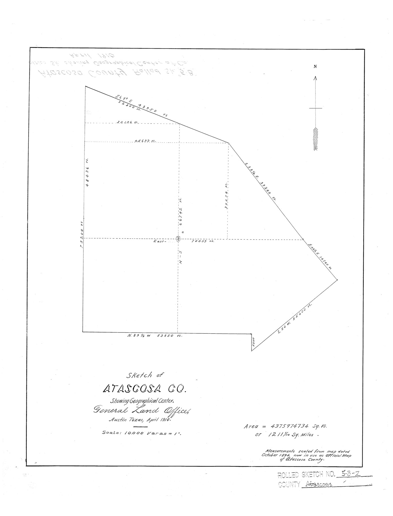
Atascosa County Rolled Sketch 5B2
Sketch of Atascosa Co. showing geographical center
-
Map/Doc
5091
-
Collection
General Map Collection
-
Object Dates
1910 (Creation Date)
-
Counties
Atascosa
-
Subjects
County Surveying Rolled Sketch
-
Height x Width
16.4 x 12.5 inches
41.7 x 31.8 cm
-
Medium
linen, manuscript
-
Scale
1" = 10000 varas
Part of: General Map Collection
Flight Mission No. BQY-1T, Frame 74, Harris County

Print $20.00
- Digital $50.00
Flight Mission No. BQY-1T, Frame 74, Harris County
1957
Size 17.5 x 17.6 inches
Map/Doc 85294
Flight Mission No. DCL-7C, Frame 144, Kenedy County

Print $20.00
- Digital $50.00
Flight Mission No. DCL-7C, Frame 144, Kenedy County
1943
Size 18.6 x 22.5 inches
Map/Doc 86101
Concho County Boundary File 2

Print $30.00
- Digital $50.00
Concho County Boundary File 2
Size 12.7 x 8.3 inches
Map/Doc 51814
Flight Mission No. DAG-23K, Frame 163, Matagorda County

Print $20.00
- Digital $50.00
Flight Mission No. DAG-23K, Frame 163, Matagorda County
1953
Size 18.6 x 22.4 inches
Map/Doc 86501
Harris County Sketch File 80b

Print $20.00
- Digital $50.00
Harris County Sketch File 80b
Size 31.5 x 17.2 inches
Map/Doc 11668
Coleman County

Print $20.00
- Digital $50.00
Coleman County
1858
Size 25.2 x 22.5 inches
Map/Doc 3409
Sutton County Boundary File 5

Print $28.00
- Digital $50.00
Sutton County Boundary File 5
Size 14.2 x 8.7 inches
Map/Doc 59046
Tarrant County

Print $40.00
- Digital $50.00
Tarrant County
1942
Size 48.6 x 37.8 inches
Map/Doc 73298
Burnet County Working Sketch 2

Print $20.00
- Digital $50.00
Burnet County Working Sketch 2
1953
Size 18.3 x 29.1 inches
Map/Doc 67845
Presidio County Rolled Sketch 131A

Print $20.00
- Digital $50.00
Presidio County Rolled Sketch 131A
Size 17.5 x 14.1 inches
Map/Doc 10707
El Paso County Boundary File 4a

Print $44.00
- Digital $50.00
El Paso County Boundary File 4a
Size 14.1 x 8.6 inches
Map/Doc 53044
Hartley County Boundary File 1

Print $64.00
- Digital $50.00
Hartley County Boundary File 1
Size 8.8 x 25.8 inches
Map/Doc 54423
You may also like
Webb County Rolled Sketch 68

Print $43.00
- Digital $50.00
Webb County Rolled Sketch 68
1910
Size 9.6 x 15.1 inches
Map/Doc 49485
Fisher County Sketch File 13

Print $20.00
- Digital $50.00
Fisher County Sketch File 13
Size 18.3 x 17.7 inches
Map/Doc 11480
Midland County Working Sketch 32

Print $40.00
- Digital $50.00
Midland County Working Sketch 32
1971
Size 51.3 x 35.5 inches
Map/Doc 71013
San Patricio County Rolled Sketch 54

Print $20.00
- Digital $50.00
San Patricio County Rolled Sketch 54
1995
Size 25.3 x 36.5 inches
Map/Doc 7740
Flight Mission No. CGI-1N, Frame 143, Cameron County

Print $20.00
- Digital $50.00
Flight Mission No. CGI-1N, Frame 143, Cameron County
1955
Size 18.6 x 22.1 inches
Map/Doc 84499
Kleberg County Rolled Sketch 10-22

Print $20.00
- Digital $50.00
Kleberg County Rolled Sketch 10-22
1952
Size 35.1 x 36.8 inches
Map/Doc 9376
Gaines County Rolled Sketch 24

Print $20.00
- Digital $50.00
Gaines County Rolled Sketch 24
1965
Size 41.8 x 31.3 inches
Map/Doc 9314
Lamar County Working Sketch 4

Print $20.00
- Digital $50.00
Lamar County Working Sketch 4
1920
Size 14.4 x 25.1 inches
Map/Doc 70265
Crockett County Rolled Sketch 92

Print $20.00
- Digital $50.00
Crockett County Rolled Sketch 92
1977
Size 43.0 x 25.2 inches
Map/Doc 5632
Shelby County Rolled Sketch 4

Print $20.00
- Digital $50.00
Shelby County Rolled Sketch 4
1942
Size 36.4 x 43.2 inches
Map/Doc 9920
Cass County Working Sketch 11

Print $3.00
- Digital $50.00
Cass County Working Sketch 11
Size 14.8 x 10.3 inches
Map/Doc 67914
