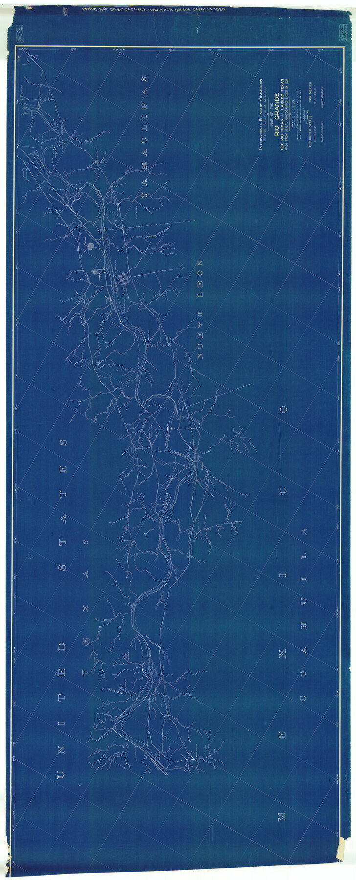
Webb County Rolled Sketch 22
Map of the Rio Grande, Del Rio, Texas to Laredo, Texas made from aerial photographs taken in 1928
-
Map/Doc
10120
-
Collection
General Map Collection
-
People and Organizations
International Boundary Commission ()
-
Counties
Webb
-
Subjects
Surveying Rolled Sketch
-
Height x Width
108.0 x 43.7 inches
274.3 x 111.0 cm
-
Medium
blueprint/diazo
Part of: General Map Collection
Plat of a survey on Padre Island in Willacy and Kenedy Counties surveyed for South Padre Development Corporation by Settles and Claunch

Print $40.00
- Digital $50.00
Plat of a survey on Padre Island in Willacy and Kenedy Counties surveyed for South Padre Development Corporation by Settles and Claunch
1966
Size 53.6 x 40.9 inches
Map/Doc 61425
Smith County Working Sketch 5

Print $20.00
- Digital $50.00
Smith County Working Sketch 5
1932
Size 32.2 x 22.4 inches
Map/Doc 63890
Map of Nacogdoches County

Print $20.00
- Digital $50.00
Map of Nacogdoches County
1881
Size 24.3 x 21.9 inches
Map/Doc 4606
Kimble County Sketch File 39

Print $12.00
- Digital $50.00
Kimble County Sketch File 39
1885
Size 14.1 x 8.6 inches
Map/Doc 28997
Pecos County Working Sketch 66

Print $20.00
- Digital $50.00
Pecos County Working Sketch 66
1955
Size 25.8 x 21.2 inches
Map/Doc 71538

Presidio County Working Sketch 9a

Print $20.00
- Digital $50.00
Presidio County Working Sketch 9a
1933
Size 17.3 x 12.2 inches
Map/Doc 71684
Baylor County Sketch File Z5

Print $4.00
- Digital $50.00
Baylor County Sketch File Z5
1902
Size 11.5 x 8.9 inches
Map/Doc 14115
[Map of Connecting Lines along or near the Red River]
![75545, [Map of Connecting Lines along or near the Red River], General Map Collection](https://historictexasmaps.com/wmedia_w700/maps/75545.tif.jpg)
Print $40.00
- Digital $50.00
[Map of Connecting Lines along or near the Red River]
Size 37.9 x 48.7 inches
Map/Doc 75545
Jeff Davis County Rolled Sketch 20

Print $20.00
- Digital $50.00
Jeff Davis County Rolled Sketch 20
1944
Size 22.7 x 19.6 inches
Map/Doc 7724
Clay County Boundary File 12

Print $8.00
- Digital $50.00
Clay County Boundary File 12
Size 14.3 x 8.8 inches
Map/Doc 51406
Williamson County Rolled Sketch 7

Print $40.00
- Digital $50.00
Williamson County Rolled Sketch 7
1924
Size 38.4 x 54.5 inches
Map/Doc 10146
You may also like
Colorado River, Taiton Sheet

Print $6.00
- Digital $50.00
Colorado River, Taiton Sheet
1941
Size 24.4 x 32.8 inches
Map/Doc 65311
Railroad Track Map, T&PRRCo., Culberson County, Texas

Print $4.00
- Digital $50.00
Railroad Track Map, T&PRRCo., Culberson County, Texas
1910
Size 11.7 x 18.6 inches
Map/Doc 62829
Map No. 1 - Rio Bravo del Norte section of boundary between the United States & Mexico agreed upon by the Joint Commission under the Treaty of Guadalupe Hidalgo

Print $20.00
- Digital $50.00
Map No. 1 - Rio Bravo del Norte section of boundary between the United States & Mexico agreed upon by the Joint Commission under the Treaty of Guadalupe Hidalgo
1852
Size 18.2 x 27.2 inches
Map/Doc 72865
Oldham County Surveyor's Oath of Office

Print $3.00
Oldham County Surveyor's Oath of Office
1881
Size 15.2 x 9.7 inches
Map/Doc 47716
Karnes County Boundary File 5b

Print $78.00
- Digital $50.00
Karnes County Boundary File 5b
Size 7.4 x 6.1 inches
Map/Doc 55723
Matagorda County Rolled Sketch 38

Print $295.00
- Digital $50.00
Matagorda County Rolled Sketch 38
1984
Size 23.2 x 23.2 inches
Map/Doc 6697
Runnels County Sketch File 18

Print $10.00
Runnels County Sketch File 18
1892
Size 14.0 x 8.4 inches
Map/Doc 35476
Gaines County Working Sketch 31

Print $20.00
- Digital $50.00
Gaines County Working Sketch 31
1990
Size 37.4 x 26.8 inches
Map/Doc 69331
Texas-Oklahoma Paris Quadrangle

Print $20.00
- Digital $50.00
Texas-Oklahoma Paris Quadrangle
Size 22.3 x 18.4 inches
Map/Doc 75107
Travis County Boundary File 24

Print $4.00
- Digital $50.00
Travis County Boundary File 24
Size 8.3 x 7.2 inches
Map/Doc 59457
Sterling County Sketch File A

Print $20.00
- Digital $50.00
Sterling County Sketch File A
1906
Size 18.2 x 26.0 inches
Map/Doc 12362
Van Zandt County Sketch File 35

Print $4.00
- Digital $50.00
Van Zandt County Sketch File 35
1862
Size 12.7 x 8.2 inches
Map/Doc 39474