Runnels County Sketch File 18
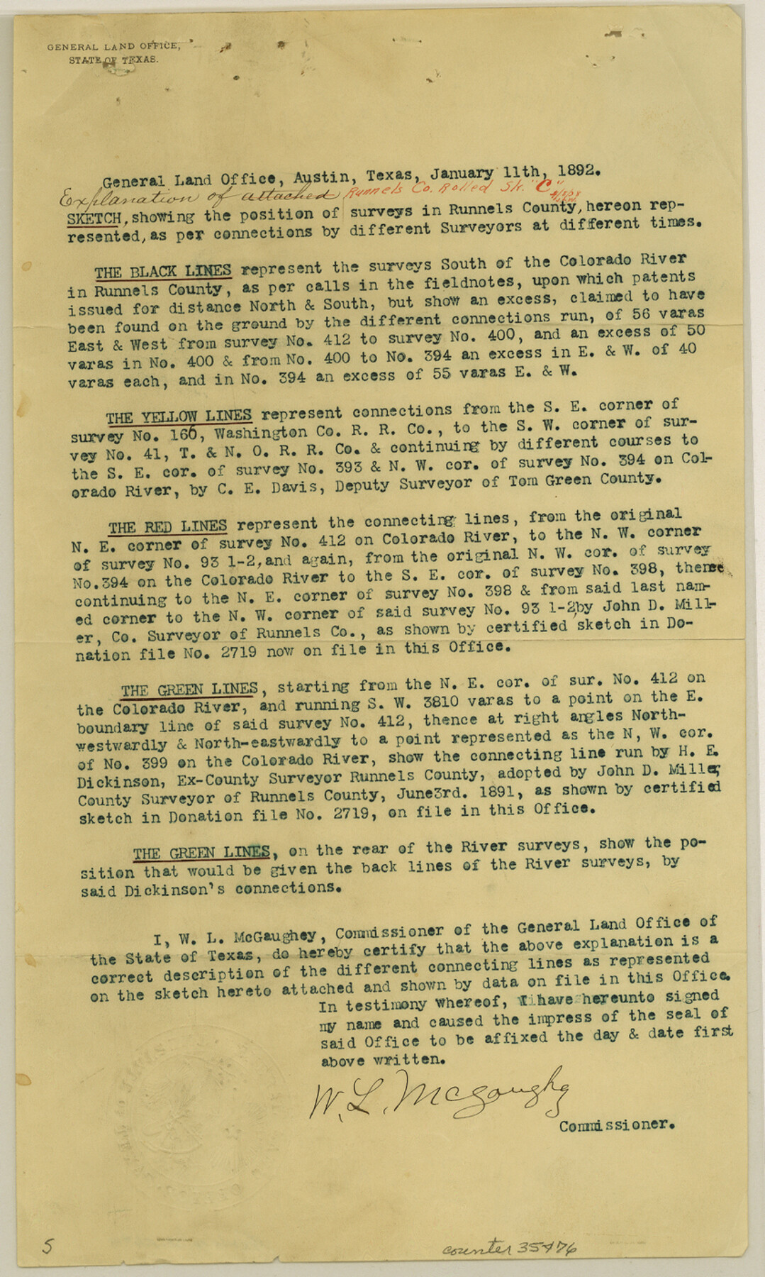
[Explanation of office sketch showing surveys south of the Colorado River in the west part of the county]
-
Map/Doc
35476
-
Collection
General Map Collection
-
Object Dates
1/11/1892 (Creation Date)
-
People and Organizations
C.E. Davis (Surveyor/Engineer)
John D. Miller (Surveyor/Engineer)
H.E. Dickinson (Surveyor/Engineer)
W.L. McGaughey (GLO Commissioner)
-
Counties
Runnels Coke Tom Green
-
Subjects
Surveying Sketch File
-
Height x Width
14.0 x 8.4 inches
35.6 x 21.3 cm
-
Medium
paper, print
-
Comments
See Runnels County Rolled Sketch C (7541) for sketch.
-
Features
Colorado River
Related maps
Runnels County Rolled Sketch C

Print $20.00
- Digital $50.00
Runnels County Rolled Sketch C
1892
Size 16.0 x 21.0 inches
Map/Doc 7541
Part of: General Map Collection
Sabine Bank to East Bay including Heald Bank

Print $20.00
- Digital $50.00
Sabine Bank to East Bay including Heald Bank
1982
Size 44.8 x 34.3 inches
Map/Doc 69852
Sutton County Working Sketch 22

Print $20.00
- Digital $50.00
Sutton County Working Sketch 22
1981
Size 33.7 x 33.4 inches
Map/Doc 62365
Flight Mission No. DAG-21K, Frame 40, Matagorda County

Print $20.00
- Digital $50.00
Flight Mission No. DAG-21K, Frame 40, Matagorda County
1952
Size 18.6 x 19.3 inches
Map/Doc 86407
San Augustine County Working Sketch 5

Print $20.00
- Digital $50.00
San Augustine County Working Sketch 5
1935
Size 39.0 x 37.4 inches
Map/Doc 63692
Flight Mission No. BRA-9M, Frame 73, Jefferson County

Print $20.00
- Digital $50.00
Flight Mission No. BRA-9M, Frame 73, Jefferson County
1953
Size 18.6 x 22.6 inches
Map/Doc 85656
Hood County Working Sketch 22

Print $20.00
- Digital $50.00
Hood County Working Sketch 22
1991
Size 17.9 x 27.1 inches
Map/Doc 66216
Van Zandt County Sketch File 49

Print $2.00
- Digital $50.00
Van Zandt County Sketch File 49
1990
Size 11.3 x 8.9 inches
Map/Doc 39510
Houston County Sketch File 27

Print $20.00
- Digital $50.00
Houston County Sketch File 27
Size 18.8 x 21.6 inches
Map/Doc 11788
Andrews County Working Sketch 2

Print $20.00
- Digital $50.00
Andrews County Working Sketch 2
1949
Size 23.2 x 23.7 inches
Map/Doc 67048
[Red River & Southwestern Ry. Co. from Henrietta to Archer City]
![64147, [Red River & Southwestern Ry. Co. from Henrietta to Archer City], General Map Collection](https://historictexasmaps.com/wmedia_w700/maps/64147.tif.jpg)
Print $20.00
- Digital $50.00
[Red River & Southwestern Ry. Co. from Henrietta to Archer City]
Size 14.3 x 21.1 inches
Map/Doc 64147
Flight Mission No. BRA-16M, Frame 93, Jefferson County

Print $20.00
- Digital $50.00
Flight Mission No. BRA-16M, Frame 93, Jefferson County
1953
Size 18.5 x 22.4 inches
Map/Doc 85705
Ward County Sketch File 13

Print $14.00
- Digital $50.00
Ward County Sketch File 13
1951
Size 14.5 x 8.8 inches
Map/Doc 39640
You may also like
United States Gulf Coast - from Galveston to the Rio Grande

Print $20.00
- Digital $50.00
United States Gulf Coast - from Galveston to the Rio Grande
1915
Size 26.9 x 18.3 inches
Map/Doc 72732
Real County Working Sketch 91

Print $20.00
- Digital $50.00
Real County Working Sketch 91
1996
Size 22.0 x 20.0 inches
Map/Doc 71983
Map of Eastland Co.

Print $20.00
- Digital $50.00
Map of Eastland Co.
1896
Size 40.0 x 42.8 inches
Map/Doc 78411
Fractional Township No. 9 South Range No. 1 East of the Indian Meridian, Indian Territory

Print $20.00
- Digital $50.00
Fractional Township No. 9 South Range No. 1 East of the Indian Meridian, Indian Territory
1898
Size 19.2 x 24.4 inches
Map/Doc 75201
Hays County Working Sketch 5

Print $20.00
- Digital $50.00
Hays County Working Sketch 5
1929
Size 28.2 x 29.6 inches
Map/Doc 66079
General Highway Map. Detail of Cities and Towns in Harris County, Texas. City Map [of] Houston, Pasadena, West University Place, Bellaire, Galena Park, Jacinto City, South Houston, South Side Place, Deer Park, and vicinity, Harris County, Texas
![79505, General Highway Map. Detail of Cities and Towns in Harris County, Texas. City Map [of] Houston, Pasadena, West University Place, Bellaire, Galena Park, Jacinto City, South Houston, South Side Place, Deer Park, and vicinity, Harris County, Texas, Texas State Library and Archives](https://historictexasmaps.com/wmedia_w700/maps/79505.tif.jpg)
Print $20.00
General Highway Map. Detail of Cities and Towns in Harris County, Texas. City Map [of] Houston, Pasadena, West University Place, Bellaire, Galena Park, Jacinto City, South Houston, South Side Place, Deer Park, and vicinity, Harris County, Texas
1961
Size 18.0 x 25.0 inches
Map/Doc 79505
[Sketch showing the southwest part of the Glidden and Sanborn Addition]
![91746, [Sketch showing the southwest part of the Glidden and Sanborn Addition], Twichell Survey Records](https://historictexasmaps.com/wmedia_w700/maps/91746-1.tif.jpg)
Print $20.00
- Digital $50.00
[Sketch showing the southwest part of the Glidden and Sanborn Addition]
Size 20.0 x 29.3 inches
Map/Doc 91746
Burleson County Working Sketch 25

Print $20.00
- Digital $50.00
Burleson County Working Sketch 25
1981
Size 27.9 x 31.0 inches
Map/Doc 67744
Callahan County Sketch File 4

Print $40.00
- Digital $50.00
Callahan County Sketch File 4
1860
Size 20.3 x 14.3 inches
Map/Doc 11037
Military Reconstruction Districts

Military Reconstruction Districts
2024
Size 8.5 x 11.0 inches
Map/Doc 97345
Nueces County Sketch File 8

Print $22.00
- Digital $50.00
Nueces County Sketch File 8
1849
Size 8.2 x 12.4 inches
Map/Doc 32512
Kimble County Sketch File 28

Print $20.00
- Digital $50.00
Kimble County Sketch File 28
Size 23.3 x 17.8 inches
Map/Doc 11927