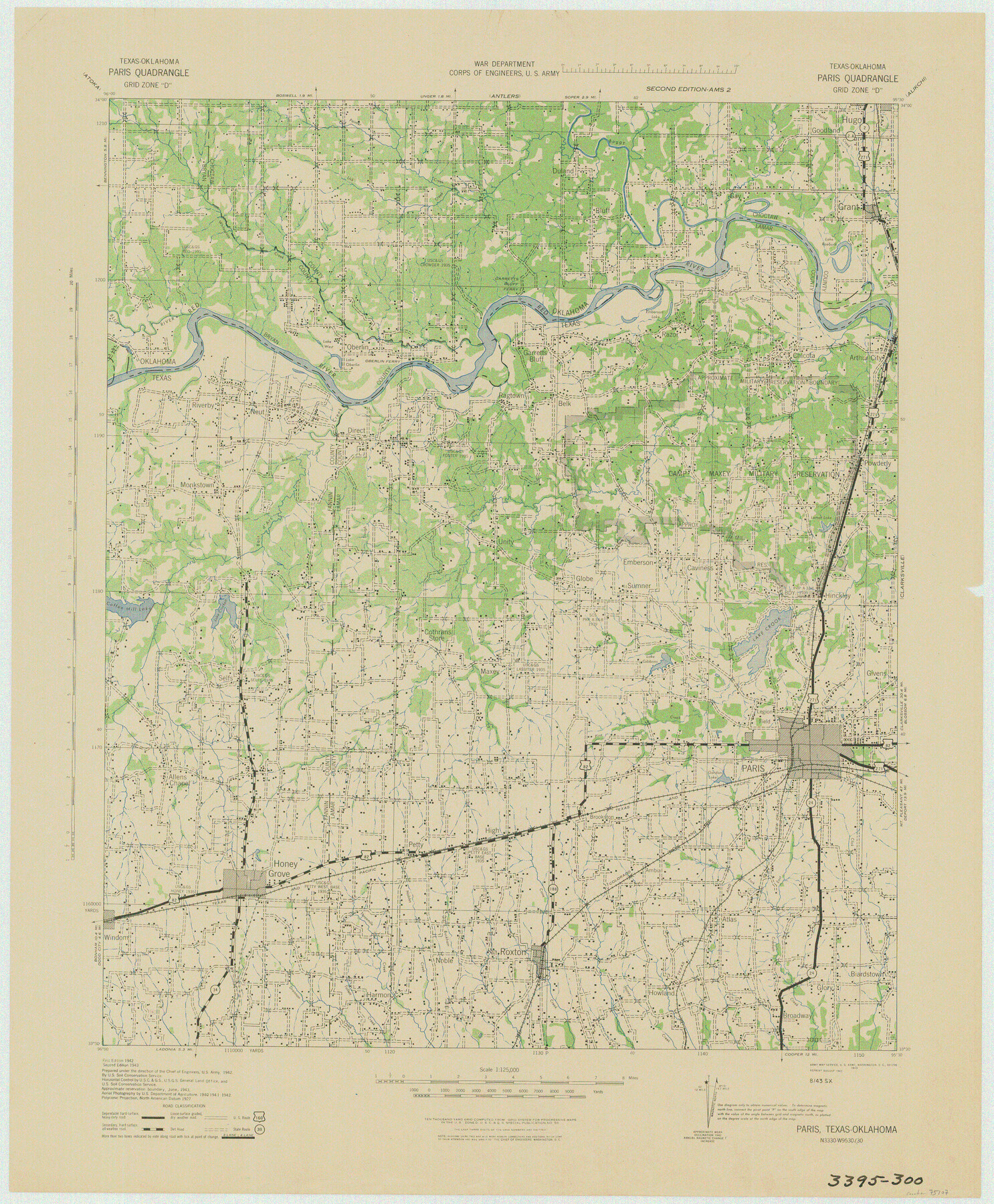
Texas-Oklahoma Paris Quadrangle
-
Map/Doc
75107
-
Collection
General Map Collection
-
Subjects
Texas Boundaries Topographic
-
Height x Width
22.3 x 18.4 inches
56.6 x 46.7 cm
-
Comments
1st Edition 1942; 2nd Edition 1943
Part of: General Map Collection
Stonewall County

Print $20.00
- Digital $50.00
Stonewall County
1902
Size 41.8 x 40.4 inches
Map/Doc 16885
Map of Hunt Co.

Print $40.00
- Digital $50.00
Map of Hunt Co.
1894
Size 49.7 x 30.0 inches
Map/Doc 16855
Map of Cameron County

Print $40.00
- Digital $50.00
Map of Cameron County
1895
Size 48.9 x 28.9 inches
Map/Doc 4901
[Sketch for Mineral Application 33721 - 33725 Incl. - Padre and Mustang Island]
![2871, [Sketch for Mineral Application 33721 - 33725 Incl. - Padre and Mustang Island], General Map Collection](https://historictexasmaps.com/wmedia_w700/maps/2871.tif.jpg)
Print $20.00
- Digital $50.00
[Sketch for Mineral Application 33721 - 33725 Incl. - Padre and Mustang Island]
1942
Size 27.0 x 22.4 inches
Map/Doc 2871
Culberson County Sketch File 38

Print $20.00
- Digital $50.00
Culberson County Sketch File 38
1964
Size 21.7 x 18.6 inches
Map/Doc 11274
Hutchinson County Sketch File 35

Print $6.00
- Digital $50.00
Hutchinson County Sketch File 35
1935
Size 11.2 x 8.9 inches
Map/Doc 27267
Kimble County Working Sketch 30

Print $20.00
- Digital $50.00
Kimble County Working Sketch 30
1942
Size 24.5 x 21.6 inches
Map/Doc 70098
Crane County Sketch File 18

Print $20.00
- Digital $50.00
Crane County Sketch File 18
1927
Size 15.1 x 18.4 inches
Map/Doc 11210

Flight Mission No. CGN-3P, Frame 142, San Patricio County

Print $20.00
- Digital $50.00
Flight Mission No. CGN-3P, Frame 142, San Patricio County
1956
Size 18.5 x 22.1 inches
Map/Doc 86986
Archer County Sketch File 8a

Print $8.00
- Digital $50.00
Archer County Sketch File 8a
Size 8.8 x 7.1 inches
Map/Doc 13639
Flight Mission No. DAG-17K, Frame 128, Matagorda County

Print $20.00
- Digital $50.00
Flight Mission No. DAG-17K, Frame 128, Matagorda County
1952
Size 18.6 x 22.3 inches
Map/Doc 86348
You may also like
Eastland County Working Sketch 27

Print $20.00
- Digital $50.00
Eastland County Working Sketch 27
1952
Size 25.2 x 21.4 inches
Map/Doc 68808
Duval County Boundary File 3a

Print $8.00
- Digital $50.00
Duval County Boundary File 3a
Size 12.7 x 8.0 inches
Map/Doc 52726
Travis County Appraisal District Plat Map 3_0404

Print $20.00
- Digital $50.00
Travis County Appraisal District Plat Map 3_0404
Size 21.5 x 26.4 inches
Map/Doc 94226
Crane County Sketch File 21

Print $7.00
- Digital $50.00
Crane County Sketch File 21
1930
Size 11.4 x 8.9 inches
Map/Doc 19590
VanZandt County Showing the Located Route of the Texas and Pacific R.R.

Print $20.00
- Digital $50.00
VanZandt County Showing the Located Route of the Texas and Pacific R.R.
1872
Size 24.5 x 22.3 inches
Map/Doc 64136
Wheeler County Sketch File 4

Print $30.00
- Digital $50.00
Wheeler County Sketch File 4
1886
Size 9.1 x 8.4 inches
Map/Doc 40000
Flight Mission No. CRE-2R, Frame 86, Jackson County

Print $20.00
- Digital $50.00
Flight Mission No. CRE-2R, Frame 86, Jackson County
1956
Size 16.0 x 15.8 inches
Map/Doc 85358
Brewster County Rolled Sketch 73

Print $20.00
- Digital $50.00
Brewster County Rolled Sketch 73
1938
Size 19.7 x 23.3 inches
Map/Doc 5239
Ector County Working Sketch 13

Print $40.00
- Digital $50.00
Ector County Working Sketch 13
1955
Size 71.8 x 43.5 inches
Map/Doc 68856
Llano County Sketch File 15

Print $2.00
- Digital $50.00
Llano County Sketch File 15
Size 10.4 x 7.7 inches
Map/Doc 30391
Map of George W. Littlefield's Ranch Located on State Capitol Leagues 657- 736 Situated in Lamb and Hockley Counties

Print $2.00
- Digital $50.00
Map of George W. Littlefield's Ranch Located on State Capitol Leagues 657- 736 Situated in Lamb and Hockley Counties
Size 6.3 x 8.2 inches
Map/Doc 91121
Wise County Sketch File 26

Print $22.00
- Digital $50.00
Wise County Sketch File 26
1855
Size 8.1 x 14.3 inches
Map/Doc 40574