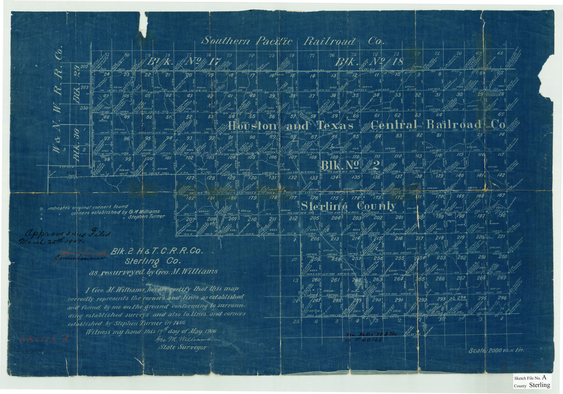
Sterling County Sketch File A
Block 2, H&TCRRCo., Sterling County, Texas
-
Map/Doc
12362
-
Collection
General Map Collection
-
Object Dates
5/14/1906 (Creation Date)
3/25/1907 (File Date)
-
People and Organizations
G.M. Williams (Surveyor/Engineer)
Stephen Tarner (Surveyor/Engineer)
-
Counties
Sterling
-
Subjects
Surveying Sketch File
-
Height x Width
18.2 x 26.0 inches
46.2 x 66.0 cm
-
Medium
blueprint/diazo
-
Scale
1:2000
-
Features
Forest Creek
Holmes Creek
Cox Hollow
McKenzie's Hollow
Part of: General Map Collection
Montgomery County Working Sketch 34

Print $20.00
- Digital $50.00
Montgomery County Working Sketch 34
1952
Size 43.0 x 35.8 inches
Map/Doc 71141
Colorado County Rolled Sketch 6

Print $20.00
- Digital $50.00
Colorado County Rolled Sketch 6
1976
Size 12.9 x 20.3 inches
Map/Doc 5533
Flight Mission No. CRK-5P, Frame 160, Refugio County

Print $20.00
- Digital $50.00
Flight Mission No. CRK-5P, Frame 160, Refugio County
1956
Size 18.6 x 22.4 inches
Map/Doc 86941
Cherokee County Sketch File 17

Print $6.00
- Digital $50.00
Cherokee County Sketch File 17
1862
Size 11.6 x 7.7 inches
Map/Doc 18156
Intracoastal Waterway in Texas - Corpus Christi to Point Isabel including Arroyo Colorado to Mo. Pac. R.R. Bridge Near Harlingen

Print $20.00
- Digital $50.00
Intracoastal Waterway in Texas - Corpus Christi to Point Isabel including Arroyo Colorado to Mo. Pac. R.R. Bridge Near Harlingen
1933
Size 28.2 x 41.0 inches
Map/Doc 61854
Travis County Working Sketch 31

Print $20.00
- Digital $50.00
Travis County Working Sketch 31
1965
Size 31.2 x 35.6 inches
Map/Doc 69415
Intracoastal Waterway in Texas - Corpus Christi to Point Isabel including Arroyo Colorado to Mo. Pac. R.R. Bridge Near Harlingen

Print $20.00
- Digital $50.00
Intracoastal Waterway in Texas - Corpus Christi to Point Isabel including Arroyo Colorado to Mo. Pac. R.R. Bridge Near Harlingen
1933
Size 28.0 x 40.7 inches
Map/Doc 61848
Newton County Sketch File 16

Print $5.00
- Digital $50.00
Newton County Sketch File 16
1880
Size 8.9 x 10.6 inches
Map/Doc 32390
El Paso County Boundary File 4a

Print $44.00
- Digital $50.00
El Paso County Boundary File 4a
Size 14.1 x 8.6 inches
Map/Doc 53044
Ellis County Sketch File 18a

Print $40.00
- Digital $50.00
Ellis County Sketch File 18a
Size 12.8 x 16.0 inches
Map/Doc 21864
Val Verde County Sketch File A1

Print $6.00
- Digital $50.00
Val Verde County Sketch File A1
1895
Size 14.4 x 9.2 inches
Map/Doc 39038
Montgomery County Working Sketch 6

Print $20.00
- Digital $50.00
Montgomery County Working Sketch 6
1932
Size 24.8 x 32.2 inches
Map/Doc 71112
You may also like
Austin County Working Sketch 9

Print $20.00
- Digital $50.00
Austin County Working Sketch 9
1996
Size 34.4 x 32.0 inches
Map/Doc 67250
South Part of Brewster Co.

Print $40.00
- Digital $50.00
South Part of Brewster Co.
1955
Size 48.2 x 40.5 inches
Map/Doc 73089
Terrell County Sketch File 16

Print $24.00
- Digital $50.00
Terrell County Sketch File 16
1902
Size 12.1 x 8.8 inches
Map/Doc 37924
General Highway Map, Bell County, Texas

Print $20.00
General Highway Map, Bell County, Texas
1961
Size 18.3 x 25.1 inches
Map/Doc 79366
Harris County Historic Topographic 37

Print $20.00
- Digital $50.00
Harris County Historic Topographic 37
1916
Size 29.8 x 23.0 inches
Map/Doc 65848
[Surveys in the Bexar District along the Balcones, Cibolo and Leon Creeks]
![63, [Surveys in the Bexar District along the Balcones, Cibolo and Leon Creeks], General Map Collection](https://historictexasmaps.com/wmedia_w700/maps/63.tif.jpg)
Print $3.00
- Digital $50.00
[Surveys in the Bexar District along the Balcones, Cibolo and Leon Creeks]
1842
Size 10.6 x 12.4 inches
Map/Doc 63
[Surveys near Brushy Creek]
![360, [Surveys near Brushy Creek], General Map Collection](https://historictexasmaps.com/wmedia_w700/maps/360.tif.jpg)
Print $2.00
- Digital $50.00
[Surveys near Brushy Creek]
1845
Size 10.0 x 7.9 inches
Map/Doc 360
Walker County Sketch File 3

Print $4.00
- Digital $50.00
Walker County Sketch File 3
1853
Size 12.8 x 8.2 inches
Map/Doc 39551
South Part Brewster Co.

Print $40.00
- Digital $50.00
South Part Brewster Co.
1915
Size 39.2 x 51.8 inches
Map/Doc 4760
Cass County Sketch File 2

Print $4.00
- Digital $50.00
Cass County Sketch File 2
1849
Size 12.4 x 7.7 inches
Map/Doc 17394
Grayson County Working Sketch 3

Print $20.00
- Digital $50.00
Grayson County Working Sketch 3
1939
Size 28.2 x 40.5 inches
Map/Doc 63242
Llano County Working Sketch 9

Print $20.00
- Digital $50.00
Llano County Working Sketch 9
1979
Size 33.4 x 24.0 inches
Map/Doc 70627