Tarrant County Boundary File 6

Print $70.00
- Digital $50.00
Tarrant County Boundary File 6
2004
Size: 11.0 x 8.5 inches
83178
Denton County Working Sketch 28

Print $20.00
- Digital $50.00
Denton County Working Sketch 28
1995
Size: 36.1 x 22.9 inches
68633
Bandera County Boundary File 6

Print $42.00
- Digital $50.00
Bandera County Boundary File 6
1972
Size: 14.2 x 8.9 inches
50303
Borden - Garza County Line as agreed upon in the 118th Judicial District Court, Howard County, Texas Case No. 13,023

Print $40.00
- Digital $50.00
Borden - Garza County Line as agreed upon in the 118th Judicial District Court, Howard County, Texas Case No. 13,023
1965
Size: 19.0 x 102.2 inches
1697
Borden and Garza County Boundary Line Plat

Print $2.00
- Digital $50.00
Borden and Garza County Boundary Line Plat
1965
Size: 14.2 x 8.8 inches
61152
Borden County Boundary File 7

Print $29.00
- Digital $50.00
Borden County Boundary File 7
1965
Size: 11.2 x 8.8 inches
61161
Harris County Boundary File 1

Print $6.00
- Digital $50.00
Harris County Boundary File 1
1963
Size: 9.2 x 11.2 inches
54292
Tarrant County Rolled Sketch 2

Print $40.00
- Digital $50.00
Tarrant County Rolled Sketch 2
1955
Size: 96.5 x 23.5 inches
9984
[Plat of Boundary Line between Comal and Hays Counties]
![65328, [Plat of Boundary Line between Comal and Hays Counties], General Map Collection](https://historictexasmaps.com/wmedia_w700/pdf_converted_jpg/qi_pdf_thumbnail_19768.jpg)
Print $20.00
- Digital $50.00
[Plat of Boundary Line between Comal and Hays Counties]
1947
Size: 11.4 x 17.7 inches
65328
Hays County Boundary File

Print $120.00
- Digital $50.00
Hays County Boundary File
1947
Size: 33.6 x 20.8 inches
65496
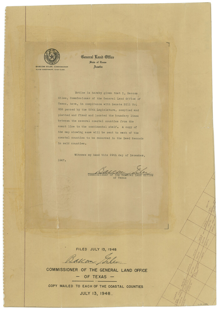
[Affadavit regarding boundary lines between the several coastal counties from coastline to Continental Shelf]
Print $20.00
- Digital $50.00
[Affadavit regarding boundary lines between the several coastal counties from coastline to Continental Shelf]
1947
Size: 18.1 x 12.7 inches
2089
Current Miscellaneous File 1

Print $12.00
- Digital $50.00
Current Miscellaneous File 1
1945
Size: 11.3 x 8.8 inches
73700
Ochiltree County Rolled Sketch 1

Print $20.00
- Digital $50.00
Ochiltree County Rolled Sketch 1
1942
Size: 29.3 x 38.8 inches
9655
Brazoria County Rolled Sketch 35

Print $40.00
- Digital $50.00
Brazoria County Rolled Sketch 35
1934
Size: 32.7 x 60.0 inches
8459
Edwards-Kinney County Line, Field Notes & Correspondence, 1933

Print $42.00
- Digital $50.00
Edwards-Kinney County Line, Field Notes & Correspondence, 1933
1931
Size: 11.2 x 8.7 inches
62881
Bastrop County Boundary File 3

Print $48.00
- Digital $50.00
Bastrop County Boundary File 3
1925
Size: 11.3 x 8.7 inches
50320
Bastrop County Boundary File 4

Print $48.00
- Digital $50.00
Bastrop County Boundary File 4
1925
Size: 11.2 x 8.7 inches
50324
Clay County Boundary File 19

Print $8.00
- Digital $50.00
Clay County Boundary File 19
1924
Size: 3.3 x 5.5 inches
65511
Bastrop County Boundary File 6

Print $40.00
- Digital $50.00
Bastrop County Boundary File 6
1923
Size: 15.4 x 102.0 inches
1691
Smith County Boundary File 1

Print $52.00
- Digital $50.00
Smith County Boundary File 1
1922
Size: 14.3 x 8.8 inches
58791
[Sketch & Field Note Calls of Pecos, Terrell & Val Verde Counties, Texas]
![1720, [Sketch & Field Note Calls of Pecos, Terrell & Val Verde Counties, Texas], General Map Collection](https://historictexasmaps.com/wmedia_w700/pdf_converted_jpg/qi_pdf_thumbnail_734.jpg)
Print $20.00
- Digital $50.00
[Sketch & Field Note Calls of Pecos, Terrell & Val Verde Counties, Texas]
1915
Size: 19.4 x 24.2 inches
1720
[Sketch with field note calls of the boundaries of Webb, Duval, Jim Wells,Nueces, Kleberg, Zapata, Jim Hogg, Brooks, Willacy, Starr, Hidalgo and Cameron Counties]
![1689, [Sketch with field note calls of the boundaries of Webb, Duval, Jim Wells,Nueces, Kleberg, Zapata, Jim Hogg, Brooks, Willacy, Starr, Hidalgo and Cameron Counties], General Map Collection](https://historictexasmaps.com/wmedia_w700/pdf_converted_jpg/qi_pdf_thumbnail_720.jpg)
Print $20.00
- Digital $50.00
[Sketch with field note calls of the boundaries of Webb, Duval, Jim Wells,Nueces, Kleberg, Zapata, Jim Hogg, Brooks, Willacy, Starr, Hidalgo and Cameron Counties]
1915
Size: 21.9 x 26.2 inches
1689
Gonzales County Working Sketch 1

Print $40.00
- Digital $50.00
Gonzales County Working Sketch 1
1913
Size: 16.8 x 49.8 inches
63216
Chambers County Boundary File 4

Print $34.00
- Digital $50.00
Chambers County Boundary File 4
1909
Size: 9.1 x 3.9 inches
51259
Borden County Boundary File 3

Print $62.00
- Digital $50.00
Borden County Boundary File 3
1908
Size: 28.7 x 82.9 inches
1695
Borden County Boundary File 4

Print $66.00
- Digital $50.00
Borden County Boundary File 4
1908
Size: 23.7 x 125.7 inches
1694
Borden County Boundary File 6

Print $28.00
- Digital $50.00
Borden County Boundary File 6
1908
Size: 11.3 x 25.1 inches
1717
[County Line between DeWitt and Lavaca Counties]
![65355, [County Line between DeWitt and Lavaca Counties], General Map Collection](https://historictexasmaps.com/wmedia_w700/pdf_converted_jpg/qi_pdf_thumbnail_19782.jpg)
Print $226.00
- Digital $50.00
[County Line between DeWitt and Lavaca Counties]
1906
Size: 17.4 x 34.4 inches
65355
A Boundary Atlas of Texas, 1821-1845

Digital $50.00
A Boundary Atlas of Texas, 1821-1845
2020
Jim Tiller’s "A Boundary Atlas of Texas, 1821-1845" is available exclusively as a digital download...
-
Map/Doc
96437
-
Creation Date
2020
Dallas County Boundary File 9

Print $6.00
- Digital $50.00
Dallas County Boundary File 9
2008
-
Map/Doc
88850
-
Creation Date
2008
Tarrant County Boundary File 6
Print $70.00
- Digital $50.00
Tarrant County Boundary File 6
2004
-
Size
11.0 x 8.5 inches
-
Map/Doc
83178
-
Creation Date
2004
Denton County Working Sketch 28
Print $20.00
- Digital $50.00
Denton County Working Sketch 28
1995
-
Size
36.1 x 22.9 inches
-
Map/Doc
68633
-
Creation Date
1995
Bandera County Boundary File 6
Print $42.00
- Digital $50.00
Bandera County Boundary File 6
1972
-
Size
14.2 x 8.9 inches
-
Map/Doc
50303
-
Creation Date
1972
Borden - Garza County Line as agreed upon in the 118th Judicial District Court, Howard County, Texas Case No. 13,023
Print $40.00
- Digital $50.00
Borden - Garza County Line as agreed upon in the 118th Judicial District Court, Howard County, Texas Case No. 13,023
1965
-
Size
19.0 x 102.2 inches
-
Map/Doc
1697
-
Creation Date
1965
Borden and Garza County Boundary Line Plat
Print $2.00
- Digital $50.00
Borden and Garza County Boundary Line Plat
1965
-
Size
14.2 x 8.8 inches
-
Map/Doc
61152
-
Creation Date
1965
Borden County Boundary File 7
Print $29.00
- Digital $50.00
Borden County Boundary File 7
1965
-
Size
11.2 x 8.8 inches
-
Map/Doc
61161
-
Creation Date
1965
Harris County Boundary File 1
Print $6.00
- Digital $50.00
Harris County Boundary File 1
1963
-
Size
9.2 x 11.2 inches
-
Map/Doc
54292
-
Creation Date
1963
Tarrant County Rolled Sketch 2
Print $40.00
- Digital $50.00
Tarrant County Rolled Sketch 2
1955
-
Size
96.5 x 23.5 inches
-
Map/Doc
9984
-
Creation Date
1955
[Plat of Boundary Line between Comal and Hays Counties]
Print $20.00
- Digital $50.00
[Plat of Boundary Line between Comal and Hays Counties]
1947
-
Size
11.4 x 17.7 inches
-
Map/Doc
65328
-
Creation Date
1947
Hays County Boundary File
Print $120.00
- Digital $50.00
Hays County Boundary File
1947
-
Size
33.6 x 20.8 inches
-
Map/Doc
65496
-
Creation Date
1947
[Affadavit regarding boundary lines between the several coastal counties from coastline to Continental Shelf]
Print $20.00
- Digital $50.00
[Affadavit regarding boundary lines between the several coastal counties from coastline to Continental Shelf]
1947
-
Size
18.1 x 12.7 inches
-
Map/Doc
2089
-
Creation Date
1947
Current Miscellaneous File 1
Print $12.00
- Digital $50.00
Current Miscellaneous File 1
1945
-
Size
11.3 x 8.8 inches
-
Map/Doc
73700
-
Creation Date
1945
Ochiltree County Rolled Sketch 1
Print $20.00
- Digital $50.00
Ochiltree County Rolled Sketch 1
1942
-
Size
29.3 x 38.8 inches
-
Map/Doc
9655
-
Creation Date
1942
Brazoria County Rolled Sketch 35
Print $40.00
- Digital $50.00
Brazoria County Rolled Sketch 35
1934
-
Size
32.7 x 60.0 inches
-
Map/Doc
8459
-
Creation Date
1934
Edwards-Kinney County Line, Field Notes & Correspondence, 1933
Print $42.00
- Digital $50.00
Edwards-Kinney County Line, Field Notes & Correspondence, 1933
1931
-
Size
11.2 x 8.7 inches
-
Map/Doc
62881
-
Creation Date
1931
Bastrop County Boundary File 3
Print $48.00
- Digital $50.00
Bastrop County Boundary File 3
1925
-
Size
11.3 x 8.7 inches
-
Map/Doc
50320
-
Creation Date
1925
Bastrop County Boundary File 4
Print $48.00
- Digital $50.00
Bastrop County Boundary File 4
1925
-
Size
11.2 x 8.7 inches
-
Map/Doc
50324
-
Creation Date
1925
Clay County Boundary File 19
Print $8.00
- Digital $50.00
Clay County Boundary File 19
1924
-
Size
3.3 x 5.5 inches
-
Map/Doc
65511
-
Creation Date
1924
Bastrop County Boundary File 6
Print $40.00
- Digital $50.00
Bastrop County Boundary File 6
1923
-
Size
15.4 x 102.0 inches
-
Map/Doc
1691
-
Creation Date
1923
Smith County Boundary File 1
Print $52.00
- Digital $50.00
Smith County Boundary File 1
1922
-
Size
14.3 x 8.8 inches
-
Map/Doc
58791
-
Creation Date
1922
[Sketch & Field Note Calls of Pecos, Terrell & Val Verde Counties, Texas]
Print $20.00
- Digital $50.00
[Sketch & Field Note Calls of Pecos, Terrell & Val Verde Counties, Texas]
1915
-
Size
19.4 x 24.2 inches
-
Map/Doc
1720
-
Creation Date
1915
[Sketch with field note calls of the boundaries of Webb, Duval, Jim Wells,Nueces, Kleberg, Zapata, Jim Hogg, Brooks, Willacy, Starr, Hidalgo and Cameron Counties]
Print $20.00
- Digital $50.00
[Sketch with field note calls of the boundaries of Webb, Duval, Jim Wells,Nueces, Kleberg, Zapata, Jim Hogg, Brooks, Willacy, Starr, Hidalgo and Cameron Counties]
1915
-
Size
21.9 x 26.2 inches
-
Map/Doc
1689
-
Creation Date
1915
Gonzales County Working Sketch 1
Print $40.00
- Digital $50.00
Gonzales County Working Sketch 1
1913
-
Size
16.8 x 49.8 inches
-
Map/Doc
63216
-
Creation Date
1913
Chambers County Boundary File 4
Print $34.00
- Digital $50.00
Chambers County Boundary File 4
1909
-
Size
9.1 x 3.9 inches
-
Map/Doc
51259
-
Creation Date
1909
Borden County Boundary File 3
Print $62.00
- Digital $50.00
Borden County Boundary File 3
1908
-
Size
28.7 x 82.9 inches
-
Map/Doc
1695
-
Creation Date
1908
Borden County Boundary File 4
Print $66.00
- Digital $50.00
Borden County Boundary File 4
1908
-
Size
23.7 x 125.7 inches
-
Map/Doc
1694
-
Creation Date
1908
Borden County Boundary File 6
Print $28.00
- Digital $50.00
Borden County Boundary File 6
1908
-
Size
11.3 x 25.1 inches
-
Map/Doc
1717
-
Creation Date
1908
[County Line between DeWitt and Lavaca Counties]
Print $226.00
- Digital $50.00
[County Line between DeWitt and Lavaca Counties]
1906
-
Size
17.4 x 34.4 inches
-
Map/Doc
65355
-
Creation Date
1906