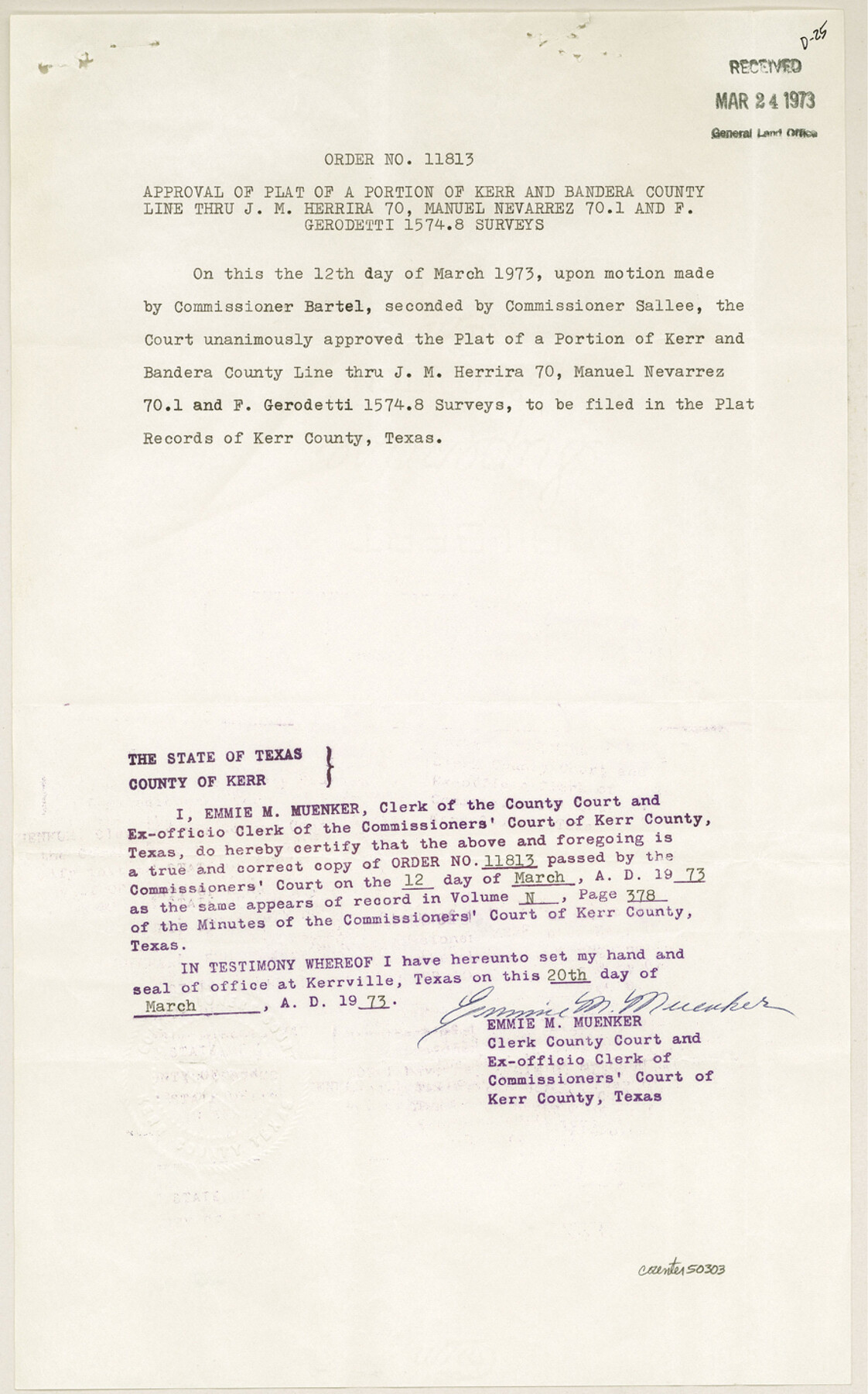
Bandera County Boundary File 6
Location of Kerr and Bandera County Line Through J. M. Herrira 70, Manuel Nevarrez 70.1 and F. Gerodetti 1574.8 Surveys
-
Map/Doc
50303
-
Collection
General Map Collection
-
Object Dates
1972/9/16 (Creation Date)
1973/3/12 (File Date)
1973/4/11 (File Date)
-
People and Organizations
Emmie M. Muenker (County/Other Clerk)
A.E. Probst Jr. (Surveyor/Engineer)
-
Counties
Bandera
-
Subjects
County Boundaries
-
Height x Width
14.2 x 8.9 inches
36.1 x 22.6 cm
-
Medium
paper, photocopy
-
Scale
1" = 300 varas
Related maps
Bandera County Sketch File 37

Print $24.00
Bandera County Sketch File 37
Size 11.0 x 8.5 inches
Map/Doc 97248
Part of: General Map Collection
Sterling County Rolled Sketch 16

Print $40.00
- Digital $50.00
Sterling County Rolled Sketch 16
1951
Size 73.6 x 43.0 inches
Map/Doc 9948
[Index map of T. & P. Ry. Company’s 80-mile Trans-Pecos Reserve’s perpetuated corners - North Part]
![89622, [Index map of T. & P. Ry. Company’s 80-mile Trans-Pecos Reserve’s perpetuated corners - North Part], General Map Collection](https://historictexasmaps.com/wmedia_w700/maps/89622-1.tif.jpg)
Print $40.00
- Digital $50.00
[Index map of T. & P. Ry. Company’s 80-mile Trans-Pecos Reserve’s perpetuated corners - North Part]
Size 25.4 x 92.1 inches
Map/Doc 89622
Reagan County Rolled Sketch 35

Print $20.00
- Digital $50.00
Reagan County Rolled Sketch 35
Size 26.4 x 38.4 inches
Map/Doc 7448
Matagorda County NRC Article 33.136 Location Key Sheet

Print $20.00
- Digital $50.00
Matagorda County NRC Article 33.136 Location Key Sheet
1995
Size 27.0 x 23.0 inches
Map/Doc 87910
Flight Mission No. CRC-2R, Frame 184, Chambers County

Print $20.00
- Digital $50.00
Flight Mission No. CRC-2R, Frame 184, Chambers County
1956
Size 18.6 x 22.2 inches
Map/Doc 84762
Jeff Davis County Sketch File 15

Print $20.00
- Digital $50.00
Jeff Davis County Sketch File 15
1883
Size 28.5 x 18.9 inches
Map/Doc 11859
Anderson County Sketch File 15a

Print $4.00
- Digital $50.00
Anderson County Sketch File 15a
1859
Size 14.5 x 8.0 inches
Map/Doc 12781
A Geographically Correct Map of the State of Texas

Print $20.00
- Digital $50.00
A Geographically Correct Map of the State of Texas
1876
Size 20.4 x 21.7 inches
Map/Doc 95361
Right of Way and Track Map, the Missouri, Kansas and Texas Ry. of Texas - Henrietta Division

Print $20.00
- Digital $50.00
Right of Way and Track Map, the Missouri, Kansas and Texas Ry. of Texas - Henrietta Division
1918
Size 11.8 x 26.8 inches
Map/Doc 64755
Comanche County Working Sketch 22

Print $20.00
- Digital $50.00
Comanche County Working Sketch 22
1974
Size 23.7 x 23.1 inches
Map/Doc 68156
Duval County Sketch File 67

Print $16.00
- Digital $50.00
Duval County Sketch File 67
1949
Size 14.2 x 8.8 inches
Map/Doc 21448
Anderson County Working Sketch 18

Print $20.00
- Digital $50.00
Anderson County Working Sketch 18
1950
Size 19.9 x 21.2 inches
Map/Doc 67018
You may also like
Baylor County Aerial Photograph Index Sheet 1

Print $20.00
- Digital $50.00
Baylor County Aerial Photograph Index Sheet 1
1950
Size 21.4 x 17.4 inches
Map/Doc 83663
[Sketch of Surveys Near Port Aransas and Aransas Pass, Aransas County, Texas]
![676, [Sketch of Surveys Near Port Aransas and Aransas Pass, Aransas County, Texas], Maddox Collection](https://historictexasmaps.com/wmedia_w700/maps/676.tif.jpg)
Print $20.00
- Digital $50.00
[Sketch of Surveys Near Port Aransas and Aransas Pass, Aransas County, Texas]
Size 22.8 x 18.5 inches
Map/Doc 676
Tom Green County Sketch File 63A

Print $20.00
- Digital $50.00
Tom Green County Sketch File 63A
1891
Size 24.9 x 34.5 inches
Map/Doc 12446
Jeff Davis County Working Sketch 33

Print $40.00
- Digital $50.00
Jeff Davis County Working Sketch 33
1977
Size 28.8 x 48.3 inches
Map/Doc 66528
Chambers County NRC Article 33.136 Sketch 13

Print $22.00
Chambers County NRC Article 33.136 Sketch 13
Size 35.9 x 23.2 inches
Map/Doc 97014
Coke County Working Sketch 21

Print $20.00
- Digital $50.00
Coke County Working Sketch 21
1949
Size 22.9 x 29.4 inches
Map/Doc 68058
Leon County Working Sketch 36

Print $20.00
- Digital $50.00
Leon County Working Sketch 36
1978
Size 36.1 x 32.5 inches
Map/Doc 70435

Map of Jefferson County

Print $20.00
- Digital $50.00
Map of Jefferson County
1896
Size 26.7 x 23.2 inches
Map/Doc 66883
Brazoria County Rolled Sketch 19

Print $20.00
- Digital $50.00
Brazoria County Rolled Sketch 19
Size 16.9 x 19.0 inches
Map/Doc 5166
Map of Texas to accompany Granger's Southern and Western Texas Guide

Print $20.00
- Digital $50.00
Map of Texas to accompany Granger's Southern and Western Texas Guide
1878
Size 26.7 x 20.8 inches
Map/Doc 96612
Brewster County Working Sketch 7

Print $20.00
- Digital $50.00
Brewster County Working Sketch 7
1909
Size 39.9 x 17.1 inches
Map/Doc 67540