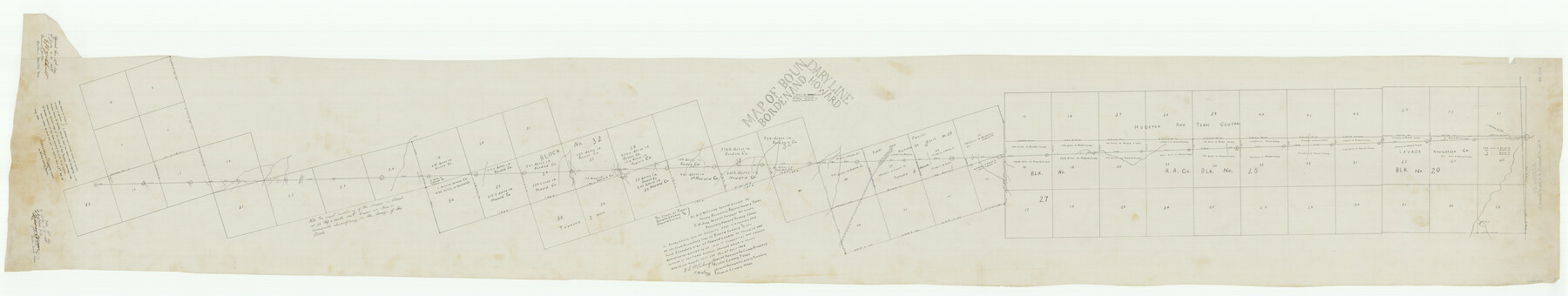
Borden County Boundary File 4
Plat of South Boundary Line of Borden and North Boundary Line of Howard County
K-7-89
- 
                          Map/Doc1694
- 
                            CollectionGeneral Map Collection
- 
                            Object Dates1908/4/20 (Creation Date)
- 
                            People and OrganizationsT.H. Seay (Draftsman)T.H. Seay (Compiler)T.H. Seay (Surveyor/Engineer)W.S. McClung (Surveyor/Engineer)
- 
                            CountiesHoward Borden
- 
                            SubjectsCounty Boundaries
- 
                            Height x Width23.7 x 125.7 inches60.2 x 319.3 cm
Part of: General Map Collection
            Matagorda County Sketch File 38


                                            Print $20.00                    
                                             -                         Digital $50.00                                    
                Matagorda County Sketch File 38
1904
Size 24.4 x 33.0 inches
                                Map/Doc 12046
            
            Blanco County Sketch File 22


                                            Print $4.00                    
                                             -                         Digital $50.00                                    
                Blanco County Sketch File 22
1884
Size 8.7 x 15.5 inches
                                Map/Doc 14604
            
            Map of Power and Hewetson Colony


                                            Print $20.00                    
                                             -                         Digital $50.00                                    
                Map of Power and Hewetson Colony
1841
Size 34.8 x 24.3 inches
                                Map/Doc 1950
            
            The Republic of Texas, March 2, 1836 - February 19, 1846


            The Republic of Texas, March 2, 1836 - February 19, 1846
1972
Size 23.4 x 18.3 inches
                                Map/Doc 2109
            
            Harbor Pass and Bar at Brazos Santiago, Texas


                                            Print $20.00                    
                                             -                         Digital $50.00                                    
                Harbor Pass and Bar at Brazos Santiago, Texas
1879
Size 18.1 x 27.4 inches
                                Map/Doc 73002
            
            Menard County Rolled Sketch 4


                                            Print $20.00                    
                                             -                         Digital $50.00                                    
                Menard County Rolled Sketch 4
Size 18.5 x 14.3 inches
                                Map/Doc 6754
            
            Grayson County Rolled Sketch 1


                                            Print $20.00                    
                                             -                         Digital $50.00                                    
                Grayson County Rolled Sketch 1
1944
Size 43.4 x 29.0 inches
                                Map/Doc 6029
            
            Duval County Sketch File 35c


                                            Print $6.00                    
                                             -                         Digital $50.00                                    
                Duval County Sketch File 35c
1935
Size 14.5 x 8.8 inches
                                Map/Doc 21377
            
            Van Zandt County Sketch File 47


                                            Print $7.00                    
                                             -                         Digital $50.00                                    
                Van Zandt County Sketch File 47
Size 10.0 x 8.1 inches
                                Map/Doc 39504
            
            Map of the Lands Surveyed by the Memphis, El Paso & Pacific R.R. Company


                                            Print $20.00                    
                                             -                         Digital $50.00                                    
                Map of the Lands Surveyed by the Memphis, El Paso & Pacific R.R. Company
1860
Size 17.7 x 21.7 inches
                                Map/Doc 4851
            
            Harris County Working Sketch 94


                                            Print $20.00                    
                                             -                         Digital $50.00                                    
                Harris County Working Sketch 94
1978
Size 20.9 x 40.2 inches
                                Map/Doc 65986
            You may also like
            Map showing A. & N. W., Raymond Word #3, S.S. Hervey #496, and M. Farley #495 corrected to conform to the judgement in Cause #2888, Travis County District Court, State of Texas versus D. Sullivan, et al


                                            Print $20.00                    
                                             -                         Digital $50.00                                    
                Map showing A. & N. W., Raymond Word #3, S.S. Hervey #496, and M. Farley #495 corrected to conform to the judgement in Cause #2888, Travis County District Court, State of Texas versus D. Sullivan, et al
1915
Size 18.5 x 30.0 inches
                                Map/Doc 75812
            
            Flight Mission No. CGI-4N, Frame 196, Cameron County


                                            Print $20.00                    
                                             -                         Digital $50.00                                    
                Flight Mission No. CGI-4N, Frame 196, Cameron County
1955
Size 18.5 x 22.2 inches
                                Map/Doc 84699
            
            Swisher County Sketch File 8


                                            Print $20.00                    
                                             -                         Digital $50.00                                    
                Swisher County Sketch File 8
1907
Size 19.2 x 16.3 inches
                                Map/Doc 12405
            
            Map of Bastrop County, Texas


                                            Print $20.00                    
                                             -                         Digital $50.00                                    
                Map of Bastrop County, Texas
1879
Size 25.2 x 23.3 inches
                                Map/Doc 693
            
            Flight Mission No. BQR-9K, Frame 6, Brazoria County


                                            Print $20.00                    
                                             -                         Digital $50.00                                    
                Flight Mission No. BQR-9K, Frame 6, Brazoria County
1952
Size 18.7 x 22.4 inches
                                Map/Doc 84035
            
            Hill County Working Sketch 5


                                            Print $20.00                    
                                             -                         Digital $50.00                                    
                Hill County Working Sketch 5
2008
Size 32.2 x 31.6 inches
                                Map/Doc 89013
            
            Map of Hopkins Co.


                                            Print $20.00                    
                                             -                         Digital $50.00                                    
                Map of Hopkins Co.
1885
Size 34.0 x 33.9 inches
                                Map/Doc 16854
            
            Chipman's Map of Briscoe, Hall, Motley, Cottle Counties


                                            Print $40.00                    
                                             -                         Digital $50.00                                    
                Chipman's Map of Briscoe, Hall, Motley, Cottle Counties
1911
Size 54.7 x 92.6 inches
                                Map/Doc 2051
            
            Brewster County Sketch File N-13


                                            Print $8.00                    
                                             -                         Digital $50.00                                    
                Brewster County Sketch File N-13
1935
Size 14.3 x 8.7 inches
                                Map/Doc 15625
            
            Reagan County


                                            Print $40.00                    
                                             -                         Digital $50.00                                    
                Reagan County
1940
Size 50.5 x 37.7 inches
                                Map/Doc 78430


                                