Travis County Sketch File 69A

Print $20.00
- Digital $50.00
Travis County Sketch File 69A
Size: 18.0 x 20.9 inches
12476
Williamson County Sketch File 16

Print $20.00
- Digital $50.00
Williamson County Sketch File 16
Size: 16.8 x 25.5 inches
12693
Travis County Sketch File 16

Print $4.00
- Digital $50.00
Travis County Sketch File 16
Size: 12.7 x 8.4 inches
38312
Williamson County Sketch File 11

Print $4.00
- Digital $50.00
Williamson County Sketch File 11
Size: 8.2 x 9.2 inches
40324
Williamson County Sketch File 19

Print $24.00
- Digital $50.00
Williamson County Sketch File 19
Size: 12.8 x 8.0 inches
40345
Williamson County Sketch File 20

Print $4.00
- Digital $50.00
Williamson County Sketch File 20
Size: 8.2 x 12.9 inches
40348

Williamson County Boundary File 1

Print $66.00
- Digital $50.00
Williamson County Boundary File 1
Size: 8.4 x 6.0 inches
59974
Williamson County Boundary File 1a

Print $4.00
- Digital $50.00
Williamson County Boundary File 1a
Size: 11.0 x 8.4 inches
59990
Williamson County Boundary File 2

Print $40.00
- Digital $50.00
Williamson County Boundary File 2
Size: 9.0 x 4.2 inches
59992
Williamson County Boundary File 3

Print $20.00
- Digital $50.00
Williamson County Boundary File 3
Size: 18.5 x 23.6 inches
60012
Williamson County Boundary File 4

Print $40.00
- Digital $50.00
Williamson County Boundary File 4
Size: 8.3 x 13.3 inches
60013
Williamson County Boundary File 5

Print $233.00
- Digital $50.00
Williamson County Boundary File 5
Size: 14.4 x 8.8 inches
60023
Williamson County Working Sketch 1

Print $20.00
- Digital $50.00
Williamson County Working Sketch 1
Size: 18.2 x 23.3 inches
72561
[East half of Travis County]
Print $20.00
- Digital $50.00
[East half of Travis County]
Size: 42.5 x 29.8 inches
75802
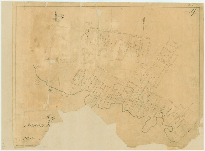
Map of Austin's Little Colony

Print $20.00
- Digital $50.00
Map of Austin's Little Colony
Size: 19.0 x 23.3 inches
76007
[Surveys along the San Gabriel River]
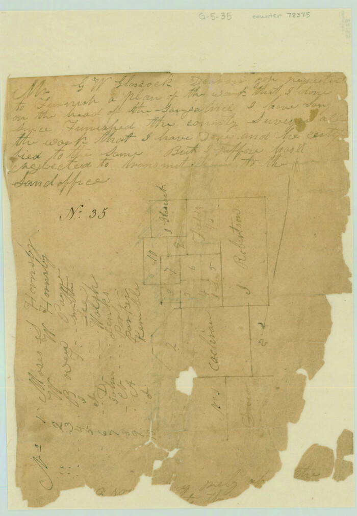
Print $2.00
- Digital $50.00
[Surveys along the San Gabriel River]
Size: 9.0 x 6.3 inches
78375
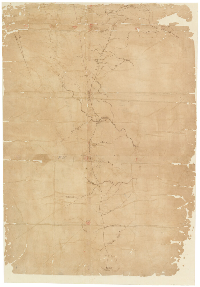
Dry Fork of Brushy Creek

Print $2.00
- Digital $50.00
Dry Fork of Brushy Creek
Size: 7.1 x 6.8 inches
78380
[Sketch of Col. Cooke's Military Road expedition from Red River to Austin]
Print $20.00
- Digital $50.00
[Sketch of Col. Cooke's Military Road expedition from Red River to Austin]
Size: 33.4 x 23.4 inches
82146
Williamson County Rolled Sketch 8

Print $20.00
- Digital $50.00
Williamson County Rolled Sketch 8
Size: 15.1 x 18.0 inches
8265
Williamson County Rolled Sketch 9

Print $20.00
- Digital $50.00
Williamson County Rolled Sketch 9
Size: 25.3 x 32.8 inches
8266
Williamson County Rolled Sketch 11

Print $20.00
- Digital $50.00
Williamson County Rolled Sketch 11
Size: 37.5 x 28.4 inches
8268
Map of Austin's Li[ttle Colony Above the] San [Antonio Road]
Print $20.00
- Digital $50.00
Map of Austin's Li[ttle Colony Above the] San [Antonio Road]
1831
Size: 14.2 x 19.3 inches
215
English Field Notes of the Spanish Archives - Book A-B

English Field Notes of the Spanish Archives - Book A-B
1835
96540
English Field Notes of the Spanish Archives - Book D

English Field Notes of the Spanish Archives - Book D
1835
96542
English Field Notes of the Spanish Archives - Books BTB, GA, BT, and X

English Field Notes of the Spanish Archives - Books BTB, GA, BT, and X
1835
96554
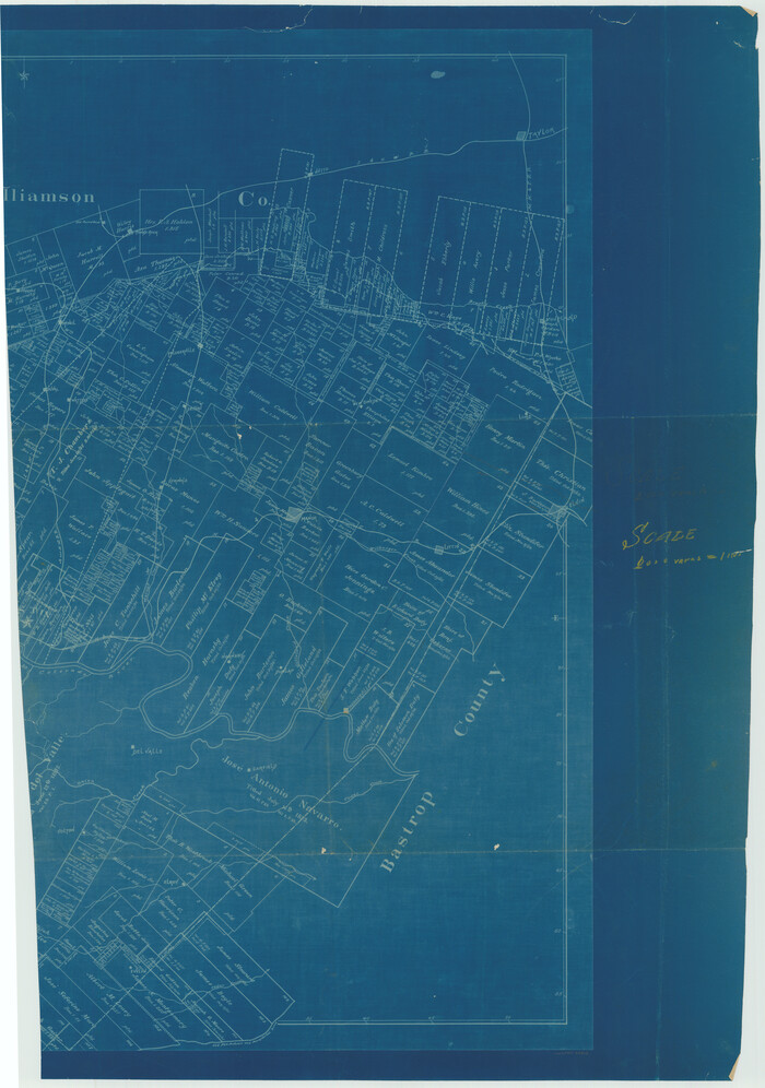
[Bastrop District]
Print $20.00
- Digital $50.00
[Bastrop District]
1838
Size: 25.1 x 46.1 inches
83517
Travis County Sketch File 69A
Print $20.00
- Digital $50.00
Travis County Sketch File 69A
-
Size
18.0 x 20.9 inches
-
Map/Doc
12476
Williamson County Sketch File 16
Print $20.00
- Digital $50.00
Williamson County Sketch File 16
-
Size
16.8 x 25.5 inches
-
Map/Doc
12693
Travis County Sketch File 16
Print $4.00
- Digital $50.00
Travis County Sketch File 16
-
Size
12.7 x 8.4 inches
-
Map/Doc
38312
Williamson County Sketch File 11
Print $4.00
- Digital $50.00
Williamson County Sketch File 11
-
Size
8.2 x 9.2 inches
-
Map/Doc
40324
Williamson County Sketch File 19
Print $24.00
- Digital $50.00
Williamson County Sketch File 19
-
Size
12.8 x 8.0 inches
-
Map/Doc
40345
Williamson County Sketch File 20
Print $4.00
- Digital $50.00
Williamson County Sketch File 20
-
Size
8.2 x 12.9 inches
-
Map/Doc
40348
Williamson County Boundary File 1
Print $66.00
- Digital $50.00
Williamson County Boundary File 1
-
Size
8.4 x 6.0 inches
-
Map/Doc
59974
Williamson County Boundary File 1a
Print $4.00
- Digital $50.00
Williamson County Boundary File 1a
-
Size
11.0 x 8.4 inches
-
Map/Doc
59990
Williamson County Boundary File 2
Print $40.00
- Digital $50.00
Williamson County Boundary File 2
-
Size
9.0 x 4.2 inches
-
Map/Doc
59992
Williamson County Boundary File 3
Print $20.00
- Digital $50.00
Williamson County Boundary File 3
-
Size
18.5 x 23.6 inches
-
Map/Doc
60012
Williamson County Boundary File 4
Print $40.00
- Digital $50.00
Williamson County Boundary File 4
-
Size
8.3 x 13.3 inches
-
Map/Doc
60013
Williamson County Boundary File 5
Print $233.00
- Digital $50.00
Williamson County Boundary File 5
-
Size
14.4 x 8.8 inches
-
Map/Doc
60023
Williamson County Working Sketch 1
Print $20.00
- Digital $50.00
Williamson County Working Sketch 1
-
Size
18.2 x 23.3 inches
-
Map/Doc
72561
[East half of Travis County]
Print $20.00
- Digital $50.00
[East half of Travis County]
-
Size
42.5 x 29.8 inches
-
Map/Doc
75802
Map of Austin's Little Colony
Print $20.00
- Digital $50.00
Map of Austin's Little Colony
-
Size
19.0 x 23.3 inches
-
Map/Doc
76007
[Surveys along the San Gabriel River]
Print $2.00
- Digital $50.00
[Surveys along the San Gabriel River]
-
Size
9.0 x 6.3 inches
-
Map/Doc
78375
Dry Fork of Brushy Creek
Print $2.00
- Digital $50.00
Dry Fork of Brushy Creek
-
Size
7.1 x 6.8 inches
-
Map/Doc
78380
[Sketch of Col. Cooke's Military Road expedition from Red River to Austin]
Print $20.00
- Digital $50.00
[Sketch of Col. Cooke's Military Road expedition from Red River to Austin]
-
Size
33.4 x 23.4 inches
-
Map/Doc
82146
Williamson County Rolled Sketch 8
Print $20.00
- Digital $50.00
Williamson County Rolled Sketch 8
-
Size
15.1 x 18.0 inches
-
Map/Doc
8265
Williamson County Rolled Sketch 9
Print $20.00
- Digital $50.00
Williamson County Rolled Sketch 9
-
Size
25.3 x 32.8 inches
-
Map/Doc
8266
Williamson County Rolled Sketch 11
Print $20.00
- Digital $50.00
Williamson County Rolled Sketch 11
-
Size
37.5 x 28.4 inches
-
Map/Doc
8268
Greater Austin, Texas Streetmap

Greater Austin, Texas Streetmap
-
Size
46.1 x 36.3 inches
-
Map/Doc
94430
Greater Austin, Texas Streetmap

Greater Austin, Texas Streetmap
-
Size
45.8 x 36.2 inches
-
Map/Doc
94431
Texas Hill Country Trail Region

Texas Hill Country Trail Region
-
Size
18.1 x 24.2 inches
-
Map/Doc
96872
Map of Austin's Li[ttle Colony Above the] San [Antonio Road]
Print $20.00
- Digital $50.00
Map of Austin's Li[ttle Colony Above the] San [Antonio Road]
1831
-
Size
14.2 x 19.3 inches
-
Map/Doc
215
-
Creation Date
1831
English Field Notes of the Spanish Archives - Book A-B
English Field Notes of the Spanish Archives - Book A-B
1835
-
Map/Doc
96540
-
Creation Date
1835
English Field Notes of the Spanish Archives - Book D
English Field Notes of the Spanish Archives - Book D
1835
-
Map/Doc
96542
-
Creation Date
1835
English Field Notes of the Spanish Archives - Books BTB, GA, BT, and X
English Field Notes of the Spanish Archives - Books BTB, GA, BT, and X
1835
-
Map/Doc
96554
-
Creation Date
1835
[Bastrop District]
Print $20.00
- Digital $50.00
[Bastrop District]
1838
-
Size
25.1 x 46.1 inches
-
Map/Doc
83517
-
Creation Date
1838