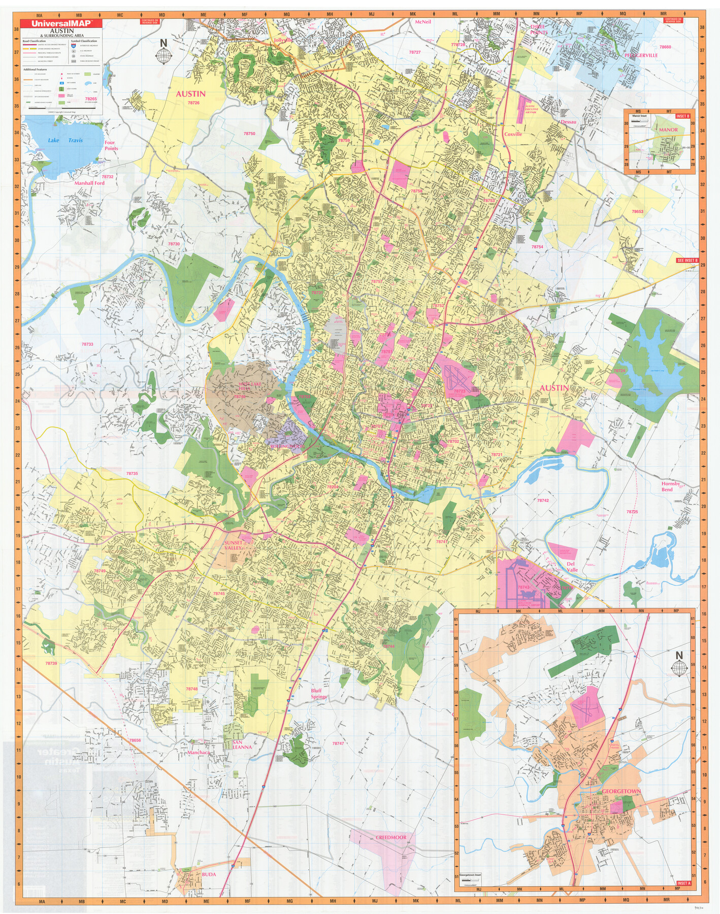
Greater Austin, Texas Streetmap
[Recto: Austin & Surrounding Area]
-
Map/Doc
94430
-
Collection
General Map Collection
-
Object Dates
2000 (Copyright Date)
-
People and Organizations
UniversalMAP (Publisher)
-
Counties
Travis Williamson
-
Subjects
City
-
Height x Width
46.1 x 36.3 inches
117.1 x 92.2 cm
-
Medium
paper, etching/engraving/lithograph
-
Comments
See 94431 for map of northern Greater Austin on verso.
Related maps
Greater Austin, Texas Streetmap

Greater Austin, Texas Streetmap
Size 45.8 x 36.2 inches
Map/Doc 94431
Part of: General Map Collection
Harris County Working Sketch 106

Print $40.00
- Digital $50.00
Harris County Working Sketch 106
1981
Size 48.0 x 25.0 inches
Map/Doc 65998
Harris County Working Sketch 102

Print $20.00
- Digital $50.00
Harris County Working Sketch 102
1980
Size 33.6 x 18.9 inches
Map/Doc 65994
Map of the City of Aransas Pass

Print $20.00
- Digital $50.00
Map of the City of Aransas Pass
1905
Size 28.3 x 21.4 inches
Map/Doc 97266
Hutchinson County Sketch File 23

Print $22.00
- Digital $50.00
Hutchinson County Sketch File 23
1913
Size 11.2 x 8.8 inches
Map/Doc 27245
Leon County Working Sketch 45

Print $20.00
- Digital $50.00
Leon County Working Sketch 45
1980
Size 45.4 x 37.4 inches
Map/Doc 70444
Map of the United States, Canada and a part of Mexico to illustrate Olney's school geography

Print $20.00
- Digital $50.00
Map of the United States, Canada and a part of Mexico to illustrate Olney's school geography
1844
Size 12.1 x 19.0 inches
Map/Doc 93537
Anderson County Working Sketch 45

Print $20.00
- Digital $50.00
Anderson County Working Sketch 45
1993
Size 41.8 x 38.0 inches
Map/Doc 67045
San Luis Pass to East Matagorda Bay

Print $20.00
- Digital $50.00
San Luis Pass to East Matagorda Bay
1960
Size 34.6 x 46.5 inches
Map/Doc 69963
Colorado County Sketch File 33

Print $44.00
- Digital $50.00
Colorado County Sketch File 33
1847
Size 13.2 x 16.2 inches
Map/Doc 18988
Leon County Sketch File 2

Print $4.00
- Digital $50.00
Leon County Sketch File 2
1852
Size 8.1 x 5.1 inches
Map/Doc 29711
Map of the Interior of Louisiana with a part of New Mexico

Print $20.00
- Digital $50.00
Map of the Interior of Louisiana with a part of New Mexico
1813
Size 11.9 x 15.7 inches
Map/Doc 94460
Sabine County Boundary File 1

Print $96.00
- Digital $50.00
Sabine County Boundary File 1
Size 14.4 x 8.8 inches
Map/Doc 58530
You may also like
Liberty County Sketch File AX

Print $10.00
- Digital $50.00
Liberty County Sketch File AX
1899
Size 14.1 x 8.5 inches
Map/Doc 30061

Flight Mission No. BRE-3P, Frame 79, Nueces County

Print $20.00
- Digital $50.00
Flight Mission No. BRE-3P, Frame 79, Nueces County
1956
Size 18.6 x 22.5 inches
Map/Doc 86820
Brewster County Working Sketch 87

Print $40.00
- Digital $50.00
Brewster County Working Sketch 87
1973
Size 37.4 x 56.6 inches
Map/Doc 67687
Ector County Working Sketch 12

Print $20.00
- Digital $50.00
Ector County Working Sketch 12
1954
Size 43.3 x 20.1 inches
Map/Doc 68855
Sketch Showing Portion of League 4, Wilson County School Land in Lynn County

Print $20.00
- Digital $50.00
Sketch Showing Portion of League 4, Wilson County School Land in Lynn County
Size 20.9 x 22.6 inches
Map/Doc 92941
Texas, Matagorda Bay, Vicinity of Trespalacios Bay

Print $40.00
- Digital $50.00
Texas, Matagorda Bay, Vicinity of Trespalacios Bay
1933
Size 49.0 x 32.6 inches
Map/Doc 69988
Flight Mission No. CRC-2R, Frame 4, Chambers County

Print $20.00
- Digital $50.00
Flight Mission No. CRC-2R, Frame 4, Chambers County
1956
Size 18.7 x 22.4 inches
Map/Doc 84723
Pecos County Sketch File 85

Print $19.00
- Digital $50.00
Pecos County Sketch File 85
1948
Size 14.6 x 9.2 inches
Map/Doc 33955
Walker County Working Sketch 15

Print $20.00
- Digital $50.00
Walker County Working Sketch 15
1967
Size 26.9 x 24.8 inches
Map/Doc 72295
Flight Mission No. DQN-6K, Frame 15, Calhoun County

Print $20.00
- Digital $50.00
Flight Mission No. DQN-6K, Frame 15, Calhoun County
1953
Size 18.4 x 22.2 inches
Map/Doc 84437
Flight Mission No. DQO-6K, Frame 20, Galveston County

Print $20.00
- Digital $50.00
Flight Mission No. DQO-6K, Frame 20, Galveston County
1952
Size 18.8 x 22.3 inches
Map/Doc 85093