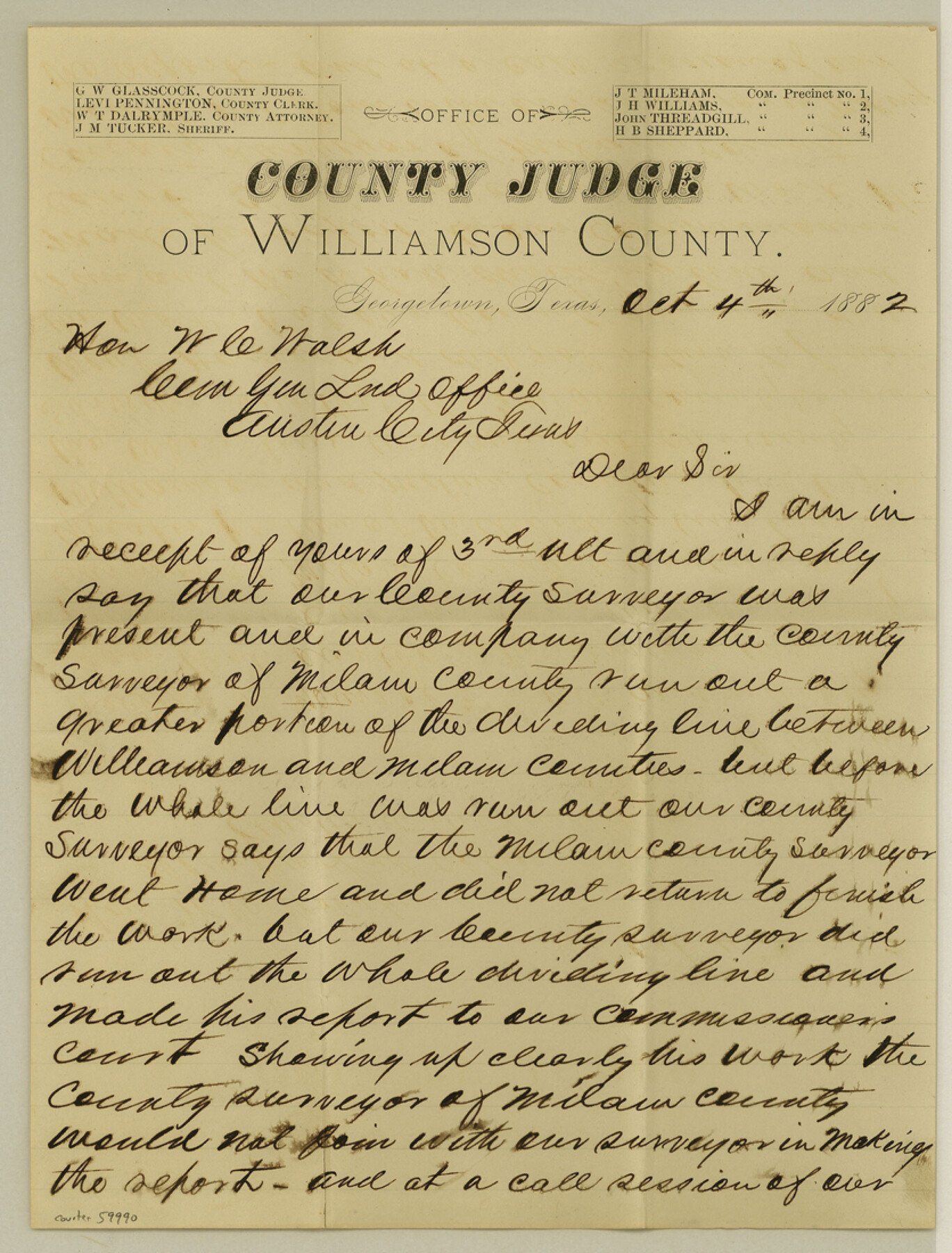
Williamson County Boundary File 1a
[Letter regarding the Milam-Williamson Boundary line]
-
Map/Doc
59990
-
Collection
General Map Collection
-
Counties
Williamson
-
Subjects
County Boundaries
-
Height x Width
11.0 x 8.4 inches
27.9 x 21.3 cm
Part of: General Map Collection
McLennan County Sketch File 30

Print $4.00
- Digital $50.00
McLennan County Sketch File 30
Size 8.4 x 7.4 inches
Map/Doc 31304
Trinity County Sketch File 35

Print $34.00
- Digital $50.00
Trinity County Sketch File 35
1920
Size 8.3 x 9.1 inches
Map/Doc 38580
Fractional Township No. 8 South Range No. 5 East of the Indian Meridian, Indian Territory

Print $20.00
- Digital $50.00
Fractional Township No. 8 South Range No. 5 East of the Indian Meridian, Indian Territory
1898
Size 19.2 x 24.4 inches
Map/Doc 75209

Dawson County

Print $20.00
- Digital $50.00
Dawson County
1959
Size 43.5 x 35.1 inches
Map/Doc 77259
Hudspeth County Working Sketch 16

Print $40.00
- Digital $50.00
Hudspeth County Working Sketch 16
Size 22.2 x 56.6 inches
Map/Doc 69649
Presidio County Sketch File 65

Print $6.00
- Digital $50.00
Presidio County Sketch File 65
1940
Size 11.0 x 15.3 inches
Map/Doc 34654
Flight Mission No. BRA-6M, Frame 73, Jefferson County

Print $20.00
- Digital $50.00
Flight Mission No. BRA-6M, Frame 73, Jefferson County
1953
Size 18.6 x 22.3 inches
Map/Doc 85417
Flight Mission No. CRC-1R, Frame 97, Chambers County

Print $20.00
- Digital $50.00
Flight Mission No. CRC-1R, Frame 97, Chambers County
1956
Size 18.7 x 22.5 inches
Map/Doc 84712
Hays County Rolled Sketch 29

Print $20.00
- Digital $50.00
Hays County Rolled Sketch 29
1954
Size 26.1 x 28.0 inches
Map/Doc 6184
Palo Pinto County

Print $20.00
- Digital $50.00
Palo Pinto County
1879
Size 24.8 x 18.4 inches
Map/Doc 3934
Brewster County Rolled Sketch 122

Print $20.00
- Digital $50.00
Brewster County Rolled Sketch 122
1974
Size 32.0 x 25.5 inches
Map/Doc 5297
You may also like
[Surveys in Williamson County]
![78376, [Surveys in Williamson County], General Map Collection](https://historictexasmaps.com/wmedia_w700/maps/78376.tif.jpg)
Print $2.00
- Digital $50.00
[Surveys in Williamson County]
1847
Size 12.6 x 8.3 inches
Map/Doc 78376
Hamilton County Working Sketch 31

Print $20.00
- Digital $50.00
Hamilton County Working Sketch 31
Size 23.3 x 18.2 inches
Map/Doc 63369
King County Working Sketch Graphic Index

Print $20.00
- Digital $50.00
King County Working Sketch Graphic Index
1947
Size 44.2 x 39.5 inches
Map/Doc 76608
Kent County Working Sketch 4

Print $20.00
- Digital $50.00
Kent County Working Sketch 4
1948
Size 27.9 x 25.8 inches
Map/Doc 70011
Geographically Correct Map of United States showing the Union Pacific System - Union Pacific R.R. Co., Oregon Short Line R.R. Co., Oregon-Washington R.R. & Nav. Co., Los Angeles & Salt Lake R.R. Co., St. Joseph & Grand Island Ry. Co. and connections

Print $20.00
- Digital $50.00
Geographically Correct Map of United States showing the Union Pacific System - Union Pacific R.R. Co., Oregon Short Line R.R. Co., Oregon-Washington R.R. & Nav. Co., Los Angeles & Salt Lake R.R. Co., St. Joseph & Grand Island Ry. Co. and connections
1922
Size 18.2 x 32.2 inches
Map/Doc 95771
Hale County Rolled Sketch 6

Print $20.00
- Digital $50.00
Hale County Rolled Sketch 6
1903
Size 35.0 x 28.9 inches
Map/Doc 6045
San Augustine County Sketch File 1

Print $4.00
San Augustine County Sketch File 1
1849
Size 9.3 x 8.2 inches
Map/Doc 35631
Presidio County Working Sketch 74

Print $20.00
- Digital $50.00
Presidio County Working Sketch 74
1962
Size 45.9 x 35.2 inches
Map/Doc 71751
Galveston County Rolled Sketch 34C

Print $20.00
- Digital $50.00
Galveston County Rolled Sketch 34C
1978
Size 29.0 x 40.8 inches
Map/Doc 5969
Rusk County Sketch File 39

Print $6.00
Rusk County Sketch File 39
1951
Size 11.3 x 8.9 inches
Map/Doc 35579
Dimmit County Sketch File 5

Print $42.00
- Digital $50.00
Dimmit County Sketch File 5
1849
Size 8.6 x 8.0 inches
Map/Doc 21064
Johnson County

Print $20.00
- Digital $50.00
Johnson County
1943
Size 42.0 x 38.8 inches
Map/Doc 73199