[Surveys in the Nacogdoches District, from the Sabine River to Cowleach Fork]
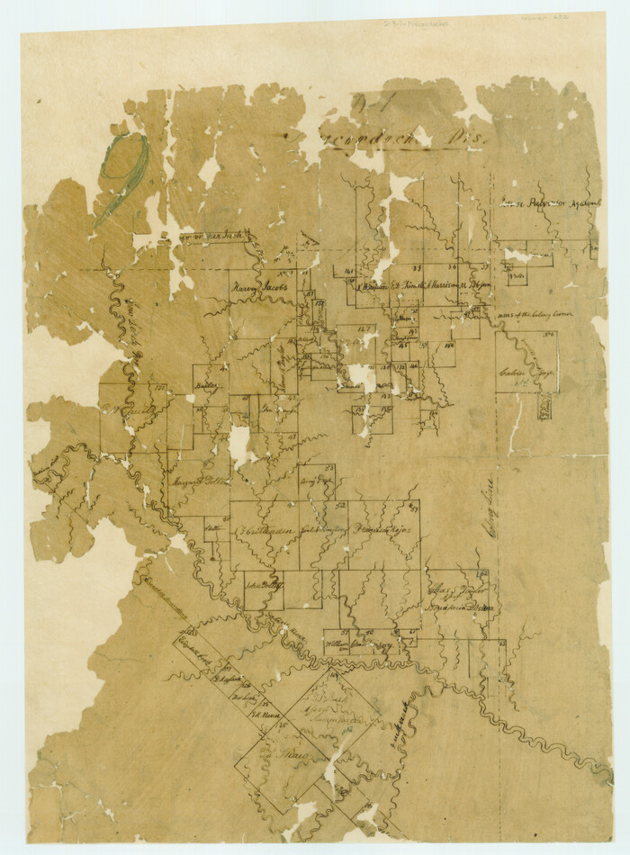
Print $3.00
- Digital $50.00
[Surveys in the Nacogdoches District, from the Sabine River to Cowleach Fork]
Size: 15.6 x 11.5 inches
282
Wood County Working Sketch 3

Print $2.00
- Digital $50.00
Wood County Working Sketch 3
1916
Size: 9.8 x 8.4 inches
62003
Wood County Working Sketch 11

Print $20.00
- Digital $50.00
Wood County Working Sketch 11
1964
Size: 31.4 x 37.4 inches
62011
Van Zandt County Working Sketch 7

Print $20.00
- Digital $50.00
Van Zandt County Working Sketch 7
1953
Size: 17.7 x 18.1 inches
72257
Van Zandt County Sketch File A45

Print $40.00
- Digital $50.00
Van Zandt County Sketch File A45
Size: 14.2 x 13.7 inches
39501
Van Zandt County Sketch File 27a

Print $22.00
- Digital $50.00
Van Zandt County Sketch File 27a
1894
Size: 17.4 x 14.5 inches
39449
Van Zandt County Rolled Sketch 10

Print $20.00
- Digital $50.00
Van Zandt County Rolled Sketch 10
1989
Size: 33.7 x 40.6 inches
10092
Sabine River, Watershed of the Sabine and Neches Rivers

Print $20.00
- Digital $50.00
Sabine River, Watershed of the Sabine and Neches Rivers
Size: 39.5 x 36.0 inches
65132
Sabine River, Rocky Ford Crossing Sheet/Cowleach Fork of the Sabine River

Print $20.00
- Digital $50.00
Sabine River, Rocky Ford Crossing Sheet/Cowleach Fork of the Sabine River
1936
Size: 38.9 x 29.2 inches
65144
Sabine River, Iron Bridge Crossing Sheet

Print $20.00
- Digital $50.00
Sabine River, Iron Bridge Crossing Sheet
1936
Size: 33.0 x 40.6 inches
65139
Sabine River, Free Bridge Sheet

Print $40.00
- Digital $50.00
Sabine River, Free Bridge Sheet
1936
Size: 27.2 x 50.6 inches
65143
Rains and Part of Van Zandt Counties, Texas

Print $20.00
Rains and Part of Van Zandt Counties, Texas
1870
Size: 22.2 x 17.3 inches
88988
Rains County Working Sketch Graphic Index

Print $20.00
- Digital $50.00
Rains County Working Sketch Graphic Index
1942
Size: 31.3 x 29.5 inches
76675
Rains County Working Sketch 9

Print $20.00
- Digital $50.00
Rains County Working Sketch 9
1976
Size: 35.8 x 31.9 inches
71835
Rains County Working Sketch 8

Print $20.00
- Digital $50.00
Rains County Working Sketch 8
1965
Size: 24.3 x 28.1 inches
71834
Rains County Working Sketch 7

Print $20.00
- Digital $50.00
Rains County Working Sketch 7
1964
Size: 32.6 x 38.6 inches
71833
Rains County Working Sketch 6

Print $20.00
- Digital $50.00
Rains County Working Sketch 6
1958
Size: 26.4 x 42.3 inches
71832
Rains County Working Sketch 5

Print $20.00
- Digital $50.00
Rains County Working Sketch 5
1950
Size: 35.2 x 42.0 inches
71831
Rains County Working Sketch 4

Print $20.00
- Digital $50.00
Rains County Working Sketch 4
1919
Size: 27.3 x 25.9 inches
71830
Rains County Working Sketch 3

Print $20.00
- Digital $50.00
Rains County Working Sketch 3
1918
Size: 22.3 x 12.5 inches
71829
Rains County Working Sketch 2

Print $20.00
- Digital $50.00
Rains County Working Sketch 2
Size: 14.0 x 12.2 inches
71828
Rains County Working Sketch 11

Print $20.00
- Digital $50.00
Rains County Working Sketch 11
Size: 40.1 x 35.1 inches
71837
Rains County Working Sketch 10

Print $20.00
- Digital $50.00
Rains County Working Sketch 10
1998
Size: 36.1 x 34.7 inches
71836
Rains County Working Sketch 1

Print $20.00
- Digital $50.00
Rains County Working Sketch 1
Size: 12.3 x 17.3 inches
71827
Rains County Sketch File 9

Print $20.00
- Digital $50.00
Rains County Sketch File 9
Size: 14.2 x 16.3 inches
34960
Rains County Sketch File 8

Print $4.00
- Digital $50.00
Rains County Sketch File 8
1872
Size: 7.6 x 8.1 inches
34958
Rains County Sketch File 7

Print $4.00
- Digital $50.00
Rains County Sketch File 7
Size: 6.2 x 7.9 inches
34956
Rains County Sketch File 6

Print $4.00
- Digital $50.00
Rains County Sketch File 6
Size: 8.0 x 9.1 inches
34954
Rains County Sketch File 4

Print $4.00
- Digital $50.00
Rains County Sketch File 4
1853
Size: 11.2 x 8.7 inches
34951
Rains County Sketch File 3

Print $8.00
- Digital $50.00
Rains County Sketch File 3
1849
Size: 6.0 x 8.6 inches
34947
[Surveys in the Nacogdoches District, from the Sabine River to Cowleach Fork]
Print $3.00
- Digital $50.00
[Surveys in the Nacogdoches District, from the Sabine River to Cowleach Fork]
-
Size
15.6 x 11.5 inches
-
Map/Doc
282
Wood County Working Sketch 3
Print $2.00
- Digital $50.00
Wood County Working Sketch 3
1916
-
Size
9.8 x 8.4 inches
-
Map/Doc
62003
-
Creation Date
1916
Wood County Working Sketch 11
Print $20.00
- Digital $50.00
Wood County Working Sketch 11
1964
-
Size
31.4 x 37.4 inches
-
Map/Doc
62011
-
Creation Date
1964
Van Zandt County Working Sketch 7
Print $20.00
- Digital $50.00
Van Zandt County Working Sketch 7
1953
-
Size
17.7 x 18.1 inches
-
Map/Doc
72257
-
Creation Date
1953
Van Zandt County Sketch File A45
Print $40.00
- Digital $50.00
Van Zandt County Sketch File A45
-
Size
14.2 x 13.7 inches
-
Map/Doc
39501
Van Zandt County Sketch File 27a
Print $22.00
- Digital $50.00
Van Zandt County Sketch File 27a
1894
-
Size
17.4 x 14.5 inches
-
Map/Doc
39449
-
Creation Date
1894
Van Zandt County Rolled Sketch 10
Print $20.00
- Digital $50.00
Van Zandt County Rolled Sketch 10
1989
-
Size
33.7 x 40.6 inches
-
Map/Doc
10092
-
Creation Date
1989
Sabine River, Watershed of the Sabine and Neches Rivers
Print $20.00
- Digital $50.00
Sabine River, Watershed of the Sabine and Neches Rivers
-
Size
39.5 x 36.0 inches
-
Map/Doc
65132
Sabine River, Rocky Ford Crossing Sheet/Cowleach Fork of the Sabine River
Print $20.00
- Digital $50.00
Sabine River, Rocky Ford Crossing Sheet/Cowleach Fork of the Sabine River
1936
-
Size
38.9 x 29.2 inches
-
Map/Doc
65144
-
Creation Date
1936
Sabine River, Iron Bridge Crossing Sheet
Print $20.00
- Digital $50.00
Sabine River, Iron Bridge Crossing Sheet
1936
-
Size
33.0 x 40.6 inches
-
Map/Doc
65139
-
Creation Date
1936
Sabine River, Free Bridge Sheet
Print $40.00
- Digital $50.00
Sabine River, Free Bridge Sheet
1936
-
Size
27.2 x 50.6 inches
-
Map/Doc
65143
-
Creation Date
1936
Rains and Part of Van Zandt Counties, Texas
Print $20.00
Rains and Part of Van Zandt Counties, Texas
1870
-
Size
22.2 x 17.3 inches
-
Map/Doc
88988
-
Creation Date
1870
Rains County Working Sketch Graphic Index
Print $20.00
- Digital $50.00
Rains County Working Sketch Graphic Index
1942
-
Size
31.3 x 29.5 inches
-
Map/Doc
76675
-
Creation Date
1942
Rains County Working Sketch 9
Print $20.00
- Digital $50.00
Rains County Working Sketch 9
1976
-
Size
35.8 x 31.9 inches
-
Map/Doc
71835
-
Creation Date
1976
Rains County Working Sketch 8
Print $20.00
- Digital $50.00
Rains County Working Sketch 8
1965
-
Size
24.3 x 28.1 inches
-
Map/Doc
71834
-
Creation Date
1965
Rains County Working Sketch 7
Print $20.00
- Digital $50.00
Rains County Working Sketch 7
1964
-
Size
32.6 x 38.6 inches
-
Map/Doc
71833
-
Creation Date
1964
Rains County Working Sketch 6
Print $20.00
- Digital $50.00
Rains County Working Sketch 6
1958
-
Size
26.4 x 42.3 inches
-
Map/Doc
71832
-
Creation Date
1958
Rains County Working Sketch 5
Print $20.00
- Digital $50.00
Rains County Working Sketch 5
1950
-
Size
35.2 x 42.0 inches
-
Map/Doc
71831
-
Creation Date
1950
Rains County Working Sketch 4
Print $20.00
- Digital $50.00
Rains County Working Sketch 4
1919
-
Size
27.3 x 25.9 inches
-
Map/Doc
71830
-
Creation Date
1919
Rains County Working Sketch 3
Print $20.00
- Digital $50.00
Rains County Working Sketch 3
1918
-
Size
22.3 x 12.5 inches
-
Map/Doc
71829
-
Creation Date
1918
Rains County Working Sketch 2
Print $20.00
- Digital $50.00
Rains County Working Sketch 2
-
Size
14.0 x 12.2 inches
-
Map/Doc
71828
Rains County Working Sketch 11
Print $20.00
- Digital $50.00
Rains County Working Sketch 11
-
Size
40.1 x 35.1 inches
-
Map/Doc
71837
Rains County Working Sketch 10
Print $20.00
- Digital $50.00
Rains County Working Sketch 10
1998
-
Size
36.1 x 34.7 inches
-
Map/Doc
71836
-
Creation Date
1998
Rains County Working Sketch 1
Print $20.00
- Digital $50.00
Rains County Working Sketch 1
-
Size
12.3 x 17.3 inches
-
Map/Doc
71827
Rains County Sketch File 9
Print $20.00
- Digital $50.00
Rains County Sketch File 9
-
Size
14.2 x 16.3 inches
-
Map/Doc
34960
Rains County Sketch File 8
Print $4.00
- Digital $50.00
Rains County Sketch File 8
1872
-
Size
7.6 x 8.1 inches
-
Map/Doc
34958
-
Creation Date
1872
Rains County Sketch File 7
Print $4.00
- Digital $50.00
Rains County Sketch File 7
-
Size
6.2 x 7.9 inches
-
Map/Doc
34956
Rains County Sketch File 6
Print $4.00
- Digital $50.00
Rains County Sketch File 6
-
Size
8.0 x 9.1 inches
-
Map/Doc
34954
Rains County Sketch File 4
Print $4.00
- Digital $50.00
Rains County Sketch File 4
1853
-
Size
11.2 x 8.7 inches
-
Map/Doc
34951
-
Creation Date
1853
Rains County Sketch File 3
Print $8.00
- Digital $50.00
Rains County Sketch File 3
1849
-
Size
6.0 x 8.6 inches
-
Map/Doc
34947
-
Creation Date
1849