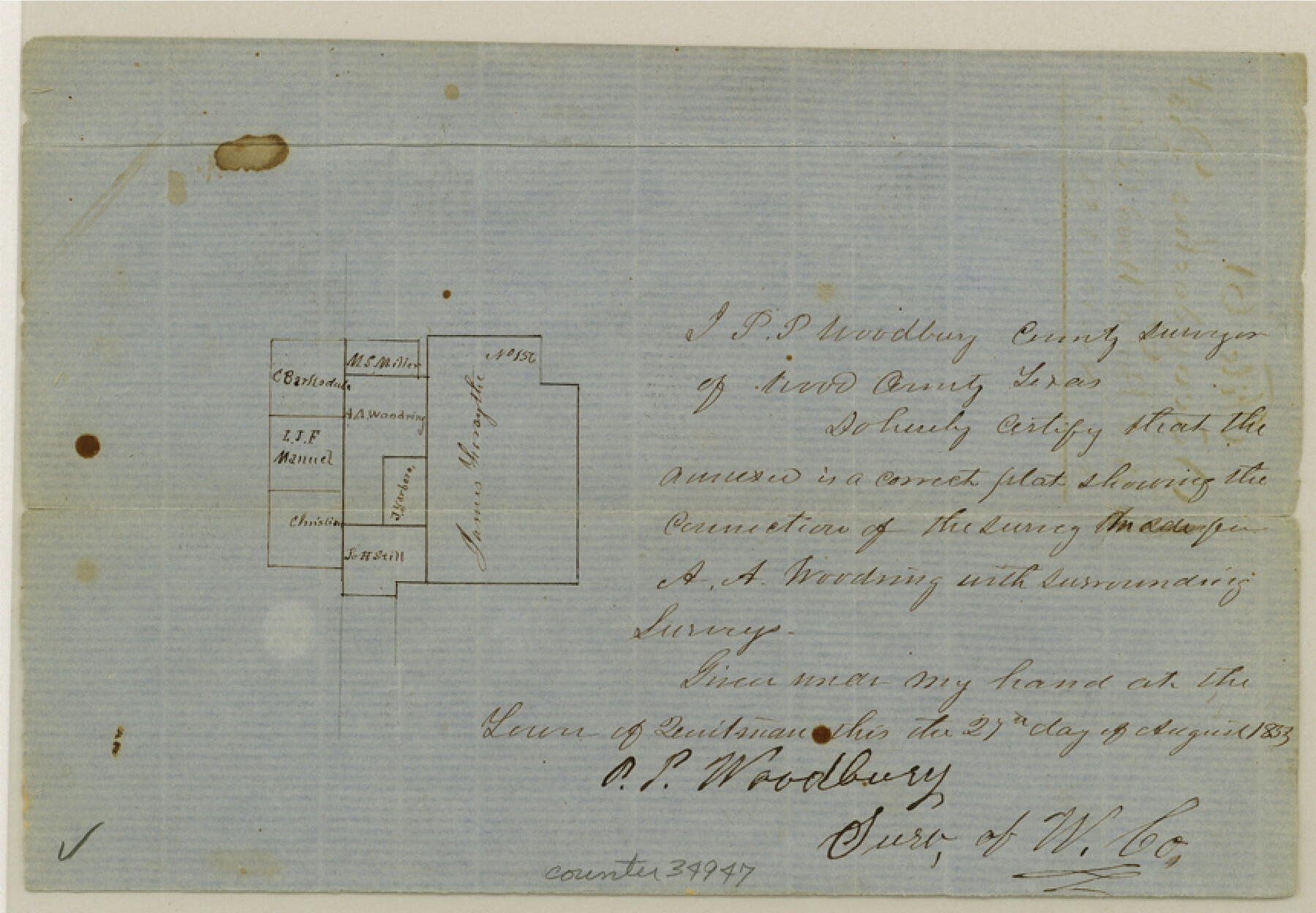
Rains County Sketch File 3
[Two sketches in Rains County along and east of Mercer's Colony line]
- 
                          Map/Doc
34947
 - 
                            Collection
General Map Collection
 - 
                            Object Dates
12/20/1849 (Creation Date)
8/27/1853 (Creation Date)
11/17/1853 (File Date)
 - 
                            People and Organizations
P.P. Woodbury (Surveyor/Engineer)
R.A. Terrell (Surveyor/Engineer)
A.A. Nelson (Surveyor/Engineer)
 - 
                            Counties
Rains
 - 
                            Subjects
Surveying Sketch File
 - 
                            Height x Width
6.0 x 8.6 inches
15.2 x 21.8 cm
 - 
                            Medium
paper, etching/engraving/lithograph
 - 
                            Features
Sabine River
Lake Fork [of Sabine River]
 
Part of: General Map Collection
            Washington County Working Sketch 1


                                            Print $20.00                    
                                             -                         Digital $50.00                                    
                Washington County Working Sketch 1
1957
Size 25.1 x 25.4 inches
                                Map/Doc 72362
            
            La Salle County Working Sketch 17


                                            Print $20.00                    
                                             -                         Digital $50.00                                    
                La Salle County Working Sketch 17
1936
Size 16.7 x 19.9 inches
                                Map/Doc 70318
            
            Travis County Rolled Sketch 18


                                            Print $20.00                    
                                             -                         Digital $50.00                                    
                Travis County Rolled Sketch 18
1940
Size 28.8 x 21.1 inches
                                Map/Doc 8020
            
            Right of Way and Track Map of The Missouri, Kansas & Texas Railway of Texas


                                            Print $40.00                    
                                             -                         Digital $50.00                                    
                Right of Way and Track Map of The Missouri, Kansas & Texas Railway of Texas
1918
Size 24.9 x 51.6 inches
                                Map/Doc 64535
            
            Topographical Map of the Rio Grande, Sheet No. 17


                                            Print $20.00                    
                                             -                         Digital $50.00                                    
                Topographical Map of the Rio Grande, Sheet No. 17
1912
Map/Doc 89541
            
            Trinity County Working Sketch 11


                                            Print $20.00                    
                                             -                         Digital $50.00                                    
                Trinity County Working Sketch 11
1949
Size 47.0 x 42.6 inches
                                Map/Doc 69460
            
            Bowie County Sketch File 10


                                            Print $8.00                    
                                             -                         Digital $50.00                                    
                Bowie County Sketch File 10
1992
Size 11.1 x 8.8 inches
                                Map/Doc 14912
            
            Clay County Sketch File 21


                                            Print $2.00                    
                                             -                         Digital $50.00                                    
                Clay County Sketch File 21
1882
Size 11.3 x 8.7 inches
                                Map/Doc 18435
            
            [Atchison, Topeka & Santa Fe from Paisano to south of Plata]


                                            Print $40.00                    
                                             -                         Digital $50.00                                    
                [Atchison, Topeka & Santa Fe from Paisano to south of Plata]
Size 34.8 x 123.1 inches
                                Map/Doc 64711
            
            Hidalgo County Sketch File 17


                                            Print $6.00                    
                                             -                         Digital $50.00                                    
                Hidalgo County Sketch File 17
1950
Size 14.5 x 8.8 inches
                                Map/Doc 26443
            
            Childress County Rolled Sketch 16A


                                            Print $20.00                    
                                             -                         Digital $50.00                                    
                Childress County Rolled Sketch 16A
Size 44.3 x 36.9 inches
                                Map/Doc 8599
            You may also like
            Flight Mission No. CRC-2R, Frame 183, Chambers County


                                            Print $20.00                    
                                             -                         Digital $50.00                                    
                Flight Mission No. CRC-2R, Frame 183, Chambers County
1956
Size 18.7 x 22.3 inches
                                Map/Doc 84761
            
            Throckmorton County Rolled Sketch 3B


                                            Print $20.00                    
                                             -                         Digital $50.00                                    
                Throckmorton County Rolled Sketch 3B
Size 31.3 x 37.9 inches
                                Map/Doc 7988
            
            Jeff Davis County Sketch File 20


                                            Print $56.00                    
                                             -                         Digital $50.00                                    
                Jeff Davis County Sketch File 20
1923
Size 11.2 x 8.8 inches
                                Map/Doc 27978
            
            Camp County Working Sketch 1


                                            Print $20.00                    
                                             -                         Digital $50.00                                    
                Camp County Working Sketch 1
1970
Size 32.9 x 29.7 inches
                                Map/Doc 67877
            
            Motley County Sketch File 12 (S)


                                            Print $4.00                    
                                             -                         Digital $50.00                                    
                Motley County Sketch File 12 (S)
Size 8.4 x 13.2 inches
                                Map/Doc 32187
            
            La Salle County Boundary File 1


                                            Print $24.00                    
                                             -                         Digital $50.00                                    
                La Salle County Boundary File 1
Size 8.7 x 14.2 inches
                                Map/Doc 56239
            
            Coryell County Working Sketch 22


                                            Print $20.00                    
                                             -                         Digital $50.00                                    
                Coryell County Working Sketch 22
1976
Size 24.9 x 35.3 inches
                                Map/Doc 68229
            
            Flight Mission No. CUG-2P, Frame 64, Kleberg County


                                            Print $20.00                    
                                             -                         Digital $50.00                                    
                Flight Mission No. CUG-2P, Frame 64, Kleberg County
1956
Size 18.4 x 22.2 inches
                                Map/Doc 86201
            
            Flight Mission No. DQO-2K, Frame 92, Galveston County


                                            Print $20.00                    
                                             -                         Digital $50.00                                    
                Flight Mission No. DQO-2K, Frame 92, Galveston County
1952
Size 18.8 x 22.5 inches
                                Map/Doc 85019
            
            Outer Continental Shelf Leasing Maps (Texas Offshore Operations)


                                            Print $20.00                    
                                             -                         Digital $50.00                                    
                Outer Continental Shelf Leasing Maps (Texas Offshore Operations)
Size 19.4 x 18.5 inches
                                Map/Doc 75849
            
            Runnels County Working Sketch 21


                                            Print $20.00                    
                                             -                         Digital $50.00                                    
                Runnels County Working Sketch 21
1951
Size 43.6 x 37.0 inches
                                Map/Doc 63617