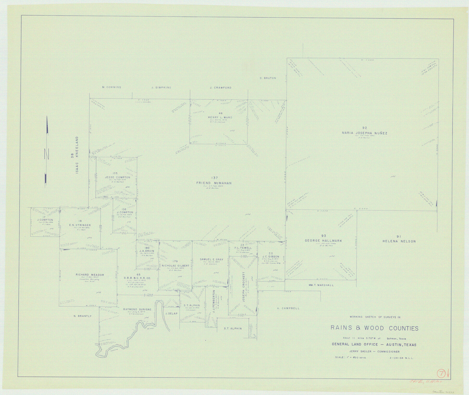
Rains County Working Sketch 7
-
Map/Doc
71833
-
Collection
General Map Collection
-
Object Dates
2/24/1964 (Creation Date)
-
People and Organizations
M. L. Liles (Draftsman)
-
Counties
Rains Wood
-
Subjects
Surveying Working Sketch
-
Height x Width
32.6 x 38.6 inches
82.8 x 98.0 cm
-
Scale
1" = 400 varas
Part of: General Map Collection
Jackson County Boundary File 2

Print $22.00
- Digital $50.00
Jackson County Boundary File 2
Size 8.6 x 4.1 inches
Map/Doc 55437
Flight Mission No. DQN-2K, Frame 80, Calhoun County

Print $20.00
- Digital $50.00
Flight Mission No. DQN-2K, Frame 80, Calhoun County
1953
Size 18.4 x 22.2 inches
Map/Doc 84272
Right of Way and Track Map - Houston & Texas Central R.R. operated by the T. and N. O. R.R. Co. - Main Line

Print $40.00
- Digital $50.00
Right of Way and Track Map - Houston & Texas Central R.R. operated by the T. and N. O. R.R. Co. - Main Line
1918
Size 26.0 x 58.1 inches
Map/Doc 82856
Presidio County Working Sketch 58

Print $20.00
- Digital $50.00
Presidio County Working Sketch 58
1956
Size 21.9 x 24.2 inches
Map/Doc 71735
Guadalupe County

Print $20.00
- Digital $50.00
Guadalupe County
1880
Size 24.9 x 22.6 inches
Map/Doc 4553
Coryell County Working Sketch 17

Print $20.00
- Digital $50.00
Coryell County Working Sketch 17
1958
Size 35.4 x 35.0 inches
Map/Doc 68224
Montague County Sketch File 8

Print $22.00
- Digital $50.00
Montague County Sketch File 8
Size 8.1 x 3.7 inches
Map/Doc 31722
Official Highway Map of the State of Vermont

Print $20.00
- Digital $50.00
Official Highway Map of the State of Vermont
1923
Size 44.8 x 28.6 inches
Map/Doc 97112
Houston Dis. Cochino Bayou

Print $2.00
- Digital $50.00
Houston Dis. Cochino Bayou
1847
Size 11.3 x 8.2 inches
Map/Doc 184
Trinity County Sketch File 4

Print $24.00
- Digital $50.00
Trinity County Sketch File 4
1858
Size 8.4 x 7.7 inches
Map/Doc 38501
Palo Pinto County Rolled Sketch 4

Print $20.00
- Digital $50.00
Palo Pinto County Rolled Sketch 4
Size 15.9 x 23.2 inches
Map/Doc 7189
Map of Goliad County

Print $20.00
- Digital $50.00
Map of Goliad County
1853
Size 30.7 x 24.2 inches
Map/Doc 3585
You may also like
Crane County Rolled Sketch 17

Print $20.00
- Digital $50.00
Crane County Rolled Sketch 17
1926
Size 20.3 x 33.8 inches
Map/Doc 5576
Angelina County Sketch File 1

Print $40.00
- Digital $50.00
Angelina County Sketch File 1
1848
Size 14.9 x 12.7 inches
Map/Doc 12919
Zavala County

Print $20.00
- Digital $50.00
Zavala County
1894
Size 40.5 x 47.9 inches
Map/Doc 63146
[Connections of Blocks C-17, B-59, T6 and C-11]
![93067, [Connections of Blocks C-17, B-59, T6 and C-11], Twichell Survey Records](https://historictexasmaps.com/wmedia_w700/maps/93067-1.tif.jpg)
Print $20.00
- Digital $50.00
[Connections of Blocks C-17, B-59, T6 and C-11]
Size 31.2 x 28.0 inches
Map/Doc 93067
Erath County Working Sketch 43

Print $20.00
- Digital $50.00
Erath County Working Sketch 43
1981
Size 19.6 x 15.7 inches
Map/Doc 69124
Panola County Rolled Sketch 4

Print $20.00
- Digital $50.00
Panola County Rolled Sketch 4
1951
Size 25.4 x 26.1 inches
Map/Doc 7198
[Surveys near Hondo Creek]
![226, [Surveys near Hondo Creek], General Map Collection](https://historictexasmaps.com/wmedia_w700/maps/226.tif.jpg)
Print $2.00
- Digital $50.00
[Surveys near Hondo Creek]
1847
Size 13.8 x 8.0 inches
Map/Doc 226
King County Working Sketch 4

Print $20.00
- Digital $50.00
King County Working Sketch 4
1939
Size 42.9 x 25.7 inches
Map/Doc 70168
Dallas County Boundary File 6c

Print $4.00
- Digital $50.00
Dallas County Boundary File 6c
Size 14.0 x 8.6 inches
Map/Doc 52227
Pecos County Working Sketch 102

Print $40.00
- Digital $50.00
Pecos County Working Sketch 102
1971
Size 36.9 x 52.7 inches
Map/Doc 71575

Newton County Sketch File 4a

Print $4.00
- Digital $50.00
Newton County Sketch File 4a
Size 12.6 x 8.0 inches
Map/Doc 32362