"Texas New Yorker's" Railroad Map of Texas

Print $20.00
"Texas New Yorker's" Railroad Map of Texas
1874
Size: 22.8 x 32.3 inches
76210
A Chart of the Internal Part of Louisiana

Print $20.00
A Chart of the Internal Part of Louisiana
1807
Size: 19.2 x 16.5 inches
79310
A Correct Map of the Seat of War in Mexico

Print $20.00
A Correct Map of the Seat of War in Mexico
1847
Size: 28.3 x 21.1 inches
79725
A Map of Louisiana and Mexico

Print $20.00
A Map of Louisiana and Mexico
1820
Size: 43.0 x 32.6 inches
76218
A Map of Texas Showing the State Parks and the Municipal Parks

Print $20.00
A Map of Texas Showing the State Parks and the Municipal Parks
1936
Size: 34.8 x 37.5 inches
76311
A Map of the Internal Provinces of New Spain

Print $20.00
A Map of the Internal Provinces of New Spain
1807
Size: 18.9 x 19.5 inches
76234
A New Map of Texas with the Contiguous American & Mexican States

Print $20.00
A New Map of Texas with the Contiguous American & Mexican States
1835
Size: 13.5 x 16.1 inches
76185
A New Map of the United States of America

Print $20.00
A New Map of the United States of America
1856
Size: 17.8 x 28.0 inches
79320
A.R. Roessler's Latest Map of the State of Texas Exhibiting Mineral and Agricultural Districts, Post Offices and Mailroutes, Railroads projected and finished, Timber, Prairie, Swamp Lands, etc. etc. etc.

Print $20.00
A.R. Roessler's Latest Map of the State of Texas Exhibiting Mineral and Agricultural Districts, Post Offices and Mailroutes, Railroads projected and finished, Timber, Prairie, Swamp Lands, etc. etc. etc.
1874
Size: 39.7 x 46.8 inches
76254
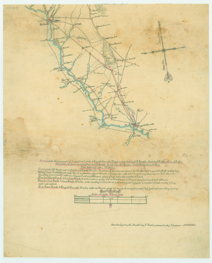
Best Route for Movements of Troops from Laredo to Ringold [sic] Barracks, Texas
Print $20.00
Best Route for Movements of Troops from Laredo to Ringold [sic] Barracks, Texas
1865
Size: 18.9 x 15.3 inches
79299
Carte Geographique, Statistique et Historique du Mexique

Print $20.00
Carte Geographique, Statistique et Historique du Mexique
1824
Size: 22.3 x 28.1 inches
79315
Carte Reduite des Costes de la Louisiane et de la Floride

Print $20.00
Carte Reduite des Costes de la Louisiane et de la Floride
1764
Size: 23.3 x 35.1 inches
79295
Carte du Mexique ou de la Nouvelle Espagne

Print $20.00
Carte du Mexique ou de la Nouvelle Espagne
1750
Size: 12.4 x 15.5 inches
79741
Central America Including Texas, California, and the Northern States Mexico

Print $20.00
Central America Including Texas, California, and the Northern States Mexico
1842
Size: 13.8 x 16.7 inches
76273
City of San Antonio, Texas

Print $20.00
City of San Antonio, Texas
1889
Size: 34.2 x 34.1 inches
76187
Clarke and Courts' Map of Jefferson County and Beaumont and Sour Lake Oil Fields

Print $20.00
Clarke and Courts' Map of Jefferson County and Beaumont and Sour Lake Oil Fields
1901
Size: 28.2 x 24.3 inches
79289
Clason's Guide Map Texas and Northern Mexico

Print $20.00
Clason's Guide Map Texas and Northern Mexico
1924
Size: 21.3 x 28.4 inches
76314
Classification of Land Uses in Texas by Counties

Print $20.00
Classification of Land Uses in Texas by Counties
1935
Size: 35.6 x 46.1 inches
76310
Coast Chart No. 106, Galveston Bay to Oyster Bay, Texas

Print $20.00
Coast Chart No. 106, Galveston Bay to Oyster Bay, Texas
1858
Size: 32.4 x 40.7 inches
76252
Coast Chart No. 107, Oyster Bay to Matagorda Bay, Texas

Print $20.00
Coast Chart No. 107, Oyster Bay to Matagorda Bay, Texas
1858
Size: 32.8 x 41.0 inches
79306
Coast Chart no. 109, Aransas Pass, Aransas and Copano Bays, Texas

Print $20.00
Coast Chart no. 109, Aransas Pass, Aransas and Copano Bays, Texas
1884
Size: 44.7 x 36.7 inches
76227
Colton's New Map of the State of Texas Compiled from J. DeCordova's large Map

Print $20.00
Colton's New Map of the State of Texas Compiled from J. DeCordova's large Map
1858
Size: 17.0 x 26.2 inches
79736
Corpus Christi is the Sportsman's Paradise

Print $20.00
Corpus Christi is the Sportsman's Paradise
1942
Size: 26.7 x 16.3 inches
79324
Corpus Christi is the Sportsman's Paradise

Print $20.00
Corpus Christi is the Sportsman's Paradise
1942
Size: 26.8 x 16.4 inches
79331
Correct Map of the Railway and Steamship Lines operated by the Southern Pacific Company

Print $20.00
Correct Map of the Railway and Steamship Lines operated by the Southern Pacific Company
1894
Size: 17.1 x 40.1 inches
79322
Correct Map of the Railway and Steamship Lines operated by the Southern Pacific Company

Print $20.00
Correct Map of the Railway and Steamship Lines operated by the Southern Pacific Company
1894
Size: 17.0 x 40.1 inches
79333
"Texas New Yorker's" Railroad Map of Texas
Print $20.00
"Texas New Yorker's" Railroad Map of Texas
1874
-
Size
22.8 x 32.3 inches
-
Map/Doc
76210
-
Creation Date
1874
A Chart of the Internal Part of Louisiana
Print $20.00
A Chart of the Internal Part of Louisiana
1807
-
Size
19.2 x 16.5 inches
-
Map/Doc
79310
-
Creation Date
1807
A Correct Map of the Seat of War in Mexico
Print $20.00
A Correct Map of the Seat of War in Mexico
1847
-
Size
28.3 x 21.1 inches
-
Map/Doc
79725
-
Creation Date
1847
A Map of Louisiana and Mexico
Print $20.00
A Map of Louisiana and Mexico
1820
-
Size
43.0 x 32.6 inches
-
Map/Doc
76218
-
Creation Date
1820
A Map of Texas Showing the State Parks and the Municipal Parks
Print $20.00
A Map of Texas Showing the State Parks and the Municipal Parks
1936
-
Size
34.8 x 37.5 inches
-
Map/Doc
76311
-
Creation Date
1936
A Map of the Internal Provinces of New Spain
Print $20.00
A Map of the Internal Provinces of New Spain
1807
-
Size
18.9 x 19.5 inches
-
Map/Doc
76234
-
Creation Date
1807
A New Map of Texas with the Contiguous American & Mexican States
Print $20.00
A New Map of Texas with the Contiguous American & Mexican States
1835
-
Size
13.5 x 16.1 inches
-
Map/Doc
76185
-
Creation Date
1835
A New Map of the United States of America
Print $20.00
A New Map of the United States of America
1856
-
Size
17.8 x 28.0 inches
-
Map/Doc
79320
-
Creation Date
1856
A.R. Roessler's Latest Map of the State of Texas Exhibiting Mineral and Agricultural Districts, Post Offices and Mailroutes, Railroads projected and finished, Timber, Prairie, Swamp Lands, etc. etc. etc.
Print $20.00
A.R. Roessler's Latest Map of the State of Texas Exhibiting Mineral and Agricultural Districts, Post Offices and Mailroutes, Railroads projected and finished, Timber, Prairie, Swamp Lands, etc. etc. etc.
1874
-
Size
39.7 x 46.8 inches
-
Map/Doc
76254
-
Creation Date
1874
Best Route for Movements of Troops from Laredo to Ringold [sic] Barracks, Texas
Print $20.00
Best Route for Movements of Troops from Laredo to Ringold [sic] Barracks, Texas
1865
-
Size
18.9 x 15.3 inches
-
Map/Doc
79299
-
Creation Date
1865
Big Bend Sheet

Print $20.00
Big Bend Sheet
1920
-
Size
32.8 x 37.2 inches
-
Map/Doc
79760
-
Creation Date
1920
Carte Geographique, Statistique et Historique du Mexique
Print $20.00
Carte Geographique, Statistique et Historique du Mexique
1824
-
Size
22.3 x 28.1 inches
-
Map/Doc
79315
-
Creation Date
1824
Carte Reduite des Costes de la Louisiane et de la Floride
Print $20.00
Carte Reduite des Costes de la Louisiane et de la Floride
1764
-
Size
23.3 x 35.1 inches
-
Map/Doc
79295
-
Creation Date
1764
Carte du Mexique ou de la Nouvelle Espagne
Print $20.00
Carte du Mexique ou de la Nouvelle Espagne
1750
-
Size
12.4 x 15.5 inches
-
Map/Doc
79741
-
Creation Date
1750
Central America Including Texas, California, and the Northern States Mexico
Print $20.00
Central America Including Texas, California, and the Northern States Mexico
1842
-
Size
13.8 x 16.7 inches
-
Map/Doc
76273
-
Creation Date
1842
Chart of Aransas Harbor

Print $20.00
Chart of Aransas Harbor
1859
-
Size
14.2 x 17.4 inches
-
Map/Doc
76292
-
Creation Date
1859
City of San Antonio, Texas
Print $20.00
City of San Antonio, Texas
1889
-
Size
34.2 x 34.1 inches
-
Map/Doc
76187
-
Creation Date
1889
Clarke and Courts' Map of Jefferson County and Beaumont and Sour Lake Oil Fields
Print $20.00
Clarke and Courts' Map of Jefferson County and Beaumont and Sour Lake Oil Fields
1901
-
Size
28.2 x 24.3 inches
-
Map/Doc
79289
-
Creation Date
1901
Clason's Guide Map Texas and Northern Mexico
Print $20.00
Clason's Guide Map Texas and Northern Mexico
1924
-
Size
21.3 x 28.4 inches
-
Map/Doc
76314
-
Creation Date
1924
Classification of Land Uses in Texas by Counties
Print $20.00
Classification of Land Uses in Texas by Counties
1935
-
Size
35.6 x 46.1 inches
-
Map/Doc
76310
-
Creation Date
1935
Coast Chart No. 106, Galveston Bay to Oyster Bay, Texas
Print $20.00
Coast Chart No. 106, Galveston Bay to Oyster Bay, Texas
1858
-
Size
32.4 x 40.7 inches
-
Map/Doc
76252
-
Creation Date
1858
Coast Chart No. 107, Oyster Bay to Matagorda Bay, Texas
Print $20.00
Coast Chart No. 107, Oyster Bay to Matagorda Bay, Texas
1858
-
Size
32.8 x 41.0 inches
-
Map/Doc
79306
-
Creation Date
1858
Coast Chart no. 109, Aransas Pass, Aransas and Copano Bays, Texas
Print $20.00
Coast Chart no. 109, Aransas Pass, Aransas and Copano Bays, Texas
1884
-
Size
44.7 x 36.7 inches
-
Map/Doc
76227
-
Creation Date
1884
Colton's New Map of the State of Texas Compiled from J. DeCordova's large Map
Print $20.00
Colton's New Map of the State of Texas Compiled from J. DeCordova's large Map
1858
-
Size
17.0 x 26.2 inches
-
Map/Doc
79736
-
Creation Date
1858
Colton's Texas

Print $20.00
Colton's Texas
1873
-
Size
17.5 x 28.2 inches
-
Map/Doc
76278
-
Creation Date
1873
Colton's Texas

Print $20.00
Colton's Texas
1873
-
Size
17.8 x 28.4 inches
-
Map/Doc
76279
-
Creation Date
1873
Corpus Christi is the Sportsman's Paradise
Print $20.00
Corpus Christi is the Sportsman's Paradise
1942
-
Size
26.7 x 16.3 inches
-
Map/Doc
79324
-
Creation Date
1942
Corpus Christi is the Sportsman's Paradise
Print $20.00
Corpus Christi is the Sportsman's Paradise
1942
-
Size
26.8 x 16.4 inches
-
Map/Doc
79331
-
Creation Date
1942
Correct Map of the Railway and Steamship Lines operated by the Southern Pacific Company
Print $20.00
Correct Map of the Railway and Steamship Lines operated by the Southern Pacific Company
1894
-
Size
17.1 x 40.1 inches
-
Map/Doc
79322
-
Creation Date
1894
Correct Map of the Railway and Steamship Lines operated by the Southern Pacific Company
Print $20.00
Correct Map of the Railway and Steamship Lines operated by the Southern Pacific Company
1894
-
Size
17.0 x 40.1 inches
-
Map/Doc
79333
-
Creation Date
1894