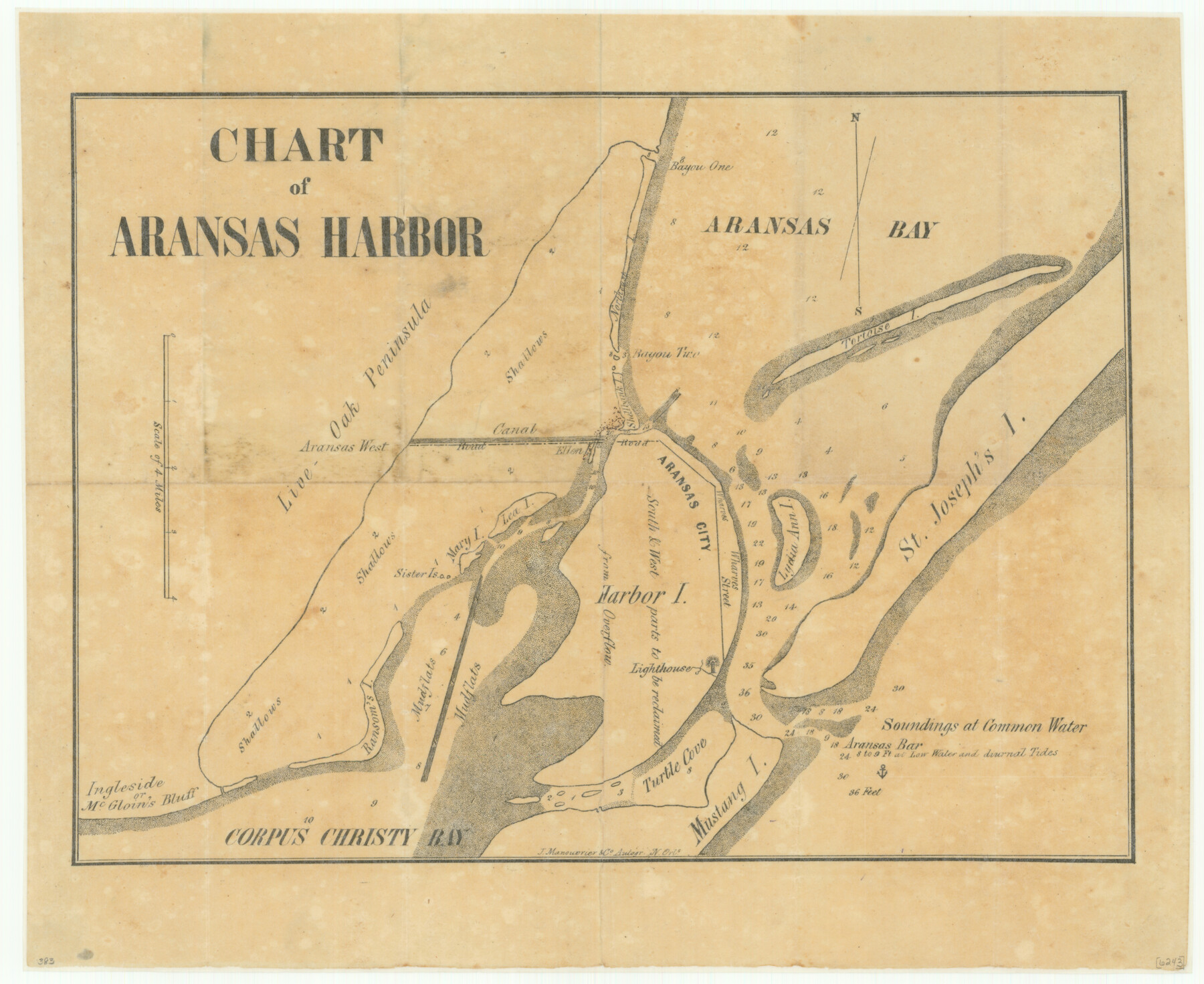
Chart of Aransas Harbor
-
Map/Doc
76292
-
Collection
Texas State Library and Archives
-
Object Dates
1859 (Creation Date)
-
People and Organizations
J. Manouorier and Company (Publisher)
-
Counties
San Patricio Aransas
-
Subjects
Nautical Charts
-
Height x Width
14.2 x 17.4 inches
36.1 x 44.2 cm
-
Comments
Prints available courtesy of the Texas State Library and Archives.
More info can be found here: TSLAC Map 06243
Part of: Texas State Library and Archives
General Highway Map, Sherman County, Texas

Print $20.00
General Highway Map, Sherman County, Texas
1961
Size 18.2 x 24.8 inches
Map/Doc 79653
Map of Texas and Parts of Adjoining Territories

Print $20.00
Map of Texas and Parts of Adjoining Territories
1899
Size 33.7 x 36.0 inches
Map/Doc 79304
General Highway Map. Detail of Cities and Towns in Smith County, Texas. City Map, Tyler and vicinity, Smith County, Texas

Print $20.00
General Highway Map. Detail of Cities and Towns in Smith County, Texas. City Map, Tyler and vicinity, Smith County, Texas
1961
Size 18.2 x 24.9 inches
Map/Doc 79657
General Highway Map, Castro County, Texas

Print $20.00
General Highway Map, Castro County, Texas
1940
Size 18.5 x 25.1 inches
Map/Doc 79043
General Highway Map, Bexar County, Texas

Print $20.00
General Highway Map, Bexar County, Texas
1961
Size 18.3 x 25.0 inches
Map/Doc 79371
Grandfield Bridge Sheet

Print $20.00
Grandfield Bridge Sheet
1920
Size 39.4 x 35.8 inches
Map/Doc 79751
General Highway Map. Detail of Cities and Towns in Navarro County, Texas

Print $20.00
General Highway Map. Detail of Cities and Towns in Navarro County, Texas
1961
Size 19.3 x 25.0 inches
Map/Doc 79611
General Highway Map, Calhoun County, Texas

Print $20.00
General Highway Map, Calhoun County, Texas
1940
Size 18.5 x 25.3 inches
Map/Doc 79036
General Highway Map. Detail of Cities and Towns in Grayson County, Texas [Denison and Sherman]
![79486, General Highway Map. Detail of Cities and Towns in Grayson County, Texas [Denison and Sherman], Texas State Library and Archives](https://historictexasmaps.com/wmedia_w700/maps/79486.tif.jpg)
Print $20.00
General Highway Map. Detail of Cities and Towns in Grayson County, Texas [Denison and Sherman]
1961
Size 18.1 x 24.6 inches
Map/Doc 79486
General Highway Map. Detail of Cities and Towns in Dallas County, Texas [Dallas and vicinity]
![79068, General Highway Map. Detail of Cities and Towns in Dallas County, Texas [Dallas and vicinity], Texas State Library and Archives](https://historictexasmaps.com/wmedia_w700/maps/79068.tif.jpg)
Print $20.00
General Highway Map. Detail of Cities and Towns in Dallas County, Texas [Dallas and vicinity]
1936
Size 18.5 x 25.2 inches
Map/Doc 79068
General Highway Map, Polk County, Texas

Print $20.00
General Highway Map, Polk County, Texas
1961
Size 18.1 x 24.5 inches
Map/Doc 79630
General Highway Map, Hall County, Texas

Print $20.00
General Highway Map, Hall County, Texas
1961
Size 18.2 x 24.6 inches
Map/Doc 79495
You may also like
Stonewall County Rolled Sketch 36B

Print $20.00
- Digital $50.00
Stonewall County Rolled Sketch 36B
Size 35.2 x 22.8 inches
Map/Doc 76404
Henderson County Sketch File 4

Print $4.00
- Digital $50.00
Henderson County Sketch File 4
1851
Size 12.9 x 8.3 inches
Map/Doc 26323
Grayson County Working Sketch 22

Print $20.00
- Digital $50.00
Grayson County Working Sketch 22
1962
Size 21.5 x 33.6 inches
Map/Doc 63261
Orange County Working Sketch 11

Print $20.00
- Digital $50.00
Orange County Working Sketch 11
1922
Size 11.9 x 14.7 inches
Map/Doc 71343
Supreme Court of the United States, October Term, 1924, No. 13, Original - The State of Oklahoma, Complainant vs. The State of Texas, Defendant, The United States, Intervener

Print $20.00
- Digital $50.00
Supreme Court of the United States, October Term, 1924, No. 13, Original - The State of Oklahoma, Complainant vs. The State of Texas, Defendant, The United States, Intervener
1924
Size 33.7 x 33.7 inches
Map/Doc 75119
Val Verde County Sketch File 41

Print $20.00
- Digital $50.00
Val Verde County Sketch File 41
1938
Size 17.8 x 22.7 inches
Map/Doc 12583
Flight Mission No. DQN-1K, Frame 105, Calhoun County

Print $20.00
- Digital $50.00
Flight Mission No. DQN-1K, Frame 105, Calhoun County
1953
Size 18.4 x 22.2 inches
Map/Doc 84172
Rains County Working Sketch 7

Print $20.00
- Digital $50.00
Rains County Working Sketch 7
1964
Size 32.6 x 38.6 inches
Map/Doc 71833
Real County Sketch File 4

Print $16.00
- Digital $50.00
Real County Sketch File 4
1913
Size 7.3 x 8.9 inches
Map/Doc 35047
Mason County Rolled Sketch 8

Print $20.00
- Digital $50.00
Mason County Rolled Sketch 8
2010
Size 18.5 x 24.4 inches
Map/Doc 89283
Crosby County Sketch File 15

Print $20.00
- Digital $50.00
Crosby County Sketch File 15
1903
Size 28.7 x 20.4 inches
Map/Doc 11250
Map of South Brady Ranch, Concho County, Texas

Print $3.00
- Digital $50.00
Map of South Brady Ranch, Concho County, Texas
1880
Size 12.9 x 10.5 inches
Map/Doc 424