Map of Texas. The Proposed Reoccupation of the Rio Grande -- Its Importance to the Union

Print $20.00
Map of Texas. The Proposed Reoccupation of the Rio Grande -- Its Importance to the Union
1965
Size: 14.1 x 8.6 inches
76264
General Highway Map, Anderson County, Texas

Print $20.00
General Highway Map, Anderson County, Texas
1961
Size: 18.3 x 25.0 inches
79346
General Highway Map, Andrews County, Texas

Print $20.00
General Highway Map, Andrews County, Texas
1961
Size: 25.1 x 18.3 inches
79347
General Highway Map, Andrews County, Texas

Print $20.00
General Highway Map, Andrews County, Texas
1961
Size: 25.2 x 18.2 inches
79348
General Highway Map, Angelina County, Texas

Print $20.00
General Highway Map, Angelina County, Texas
1961
Size: 25.1 x 18.1 inches
79349
General Highway Map, Angelina County, Texas

Print $20.00
General Highway Map, Angelina County, Texas
1961
Size: 25.1 x 18.4 inches
79350
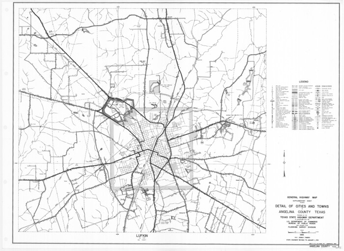
General Highway Map. Detail of Cities and Towns in Angelina County, Texas [Lufkin and vicinity]
Print $20.00
General Highway Map. Detail of Cities and Towns in Angelina County, Texas [Lufkin and vicinity]
1961
Size: 18.3 x 25.0 inches
79351
General Highway Map, Aransas County, Texas

Print $20.00
General Highway Map, Aransas County, Texas
1961
Size: 18.3 x 25.0 inches
79352
General Highway Map, Archer County, Texas

Print $20.00
General Highway Map, Archer County, Texas
1961
Size: 18.3 x 25.0 inches
79353
General Highway Map, Armstrong County, Texas

Print $20.00
General Highway Map, Armstrong County, Texas
1961
Size: 18.3 x 25.0 inches
79354
General Highway Map, Atascosa County, Texas

Print $20.00
General Highway Map, Atascosa County, Texas
1961
Size: 18.3 x 25.0 inches
79355
General Highway Map, Atascosa County, Texas

Print $20.00
General Highway Map, Atascosa County, Texas
1961
Size: 18.3 x 24.9 inches
79356
General Highway Map, Austin County, Texas

Print $20.00
General Highway Map, Austin County, Texas
1961
Size: 18.1 x 25.1 inches
79357
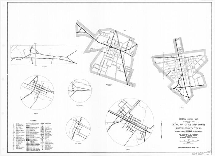
General Highway Map. Detail of Cities and Towns in Austin County, Texas [Sealy and Bellville, etc.]
Print $20.00
General Highway Map. Detail of Cities and Towns in Austin County, Texas [Sealy and Bellville, etc.]
1961
Size: 18.2 x 25.0 inches
79358
General Highway Map, Bailey County, Texas

Print $20.00
General Highway Map, Bailey County, Texas
1961
Size: 25.0 x 18.2 inches
79359
General Highway Map, Bandera County, Texas

Print $20.00
General Highway Map, Bandera County, Texas
1961
Size: 18.3 x 25.0 inches
79360
General Highway Map, Bastrop County, Texas

Print $20.00
General Highway Map, Bastrop County, Texas
1961
Size: 18.3 x 24.8 inches
79361
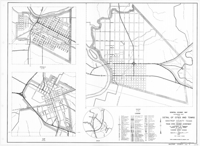
General Highway Map. Detail of Cities and Towns in Bastrop County, Texas [Bastrop, Smithville, Elgin, etc.]
Print $20.00
General Highway Map. Detail of Cities and Towns in Bastrop County, Texas [Bastrop, Smithville, Elgin, etc.]
1961
Size: 18.3 x 25.0 inches
79362
General Highway Map, Baylor County, Texas

Print $20.00
General Highway Map, Baylor County, Texas
1961
Size: 18.3 x 24.8 inches
79363
General Highway Map, Bee County, Texas

Print $20.00
General Highway Map, Bee County, Texas
1961
Size: 25.1 x 18.3 inches
79364
General Highway Map. Detail of Cities and Towns in Bee County, Texas. City Map of Beeville, Bee County, Texas

Print $20.00
General Highway Map. Detail of Cities and Towns in Bee County, Texas. City Map of Beeville, Bee County, Texas
1961
Size: 25.0 x 18.2 inches
79365
General Highway Map, Bell County, Texas

Print $20.00
General Highway Map, Bell County, Texas
1961
Size: 18.3 x 25.1 inches
79366
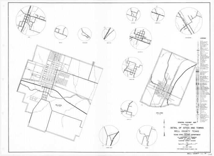
General Highway Map. Detail of Cities and Towns in Bell County, Texas [Killeen and Holland, etc.]
Print $20.00
General Highway Map. Detail of Cities and Towns in Bell County, Texas [Killeen and Holland, etc.]
1961
Size: 18.2 x 25.0 inches
79367
General Highway Map. Detail of Cities and Towns in Bell County, Texas [Temple]
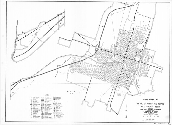
Print $20.00
General Highway Map. Detail of Cities and Towns in Bell County, Texas [Temple]
1961
Size: 18.2 x 25.0 inches
79368
General Highway Map. Detail of Cities and Towns in Bell County, Texas [Belton and Rogers and vicinity]
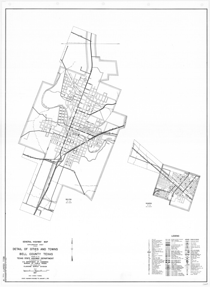
Print $20.00
General Highway Map. Detail of Cities and Towns in Bell County, Texas [Belton and Rogers and vicinity]
1961
Size: 25.0 x 18.3 inches
79369
General Highway Map, Bexar County, Texas

Print $20.00
General Highway Map, Bexar County, Texas
1961
Size: 18.4 x 25.0 inches
79370
General Highway Map, Bexar County, Texas

Print $20.00
General Highway Map, Bexar County, Texas
1961
Size: 18.3 x 25.0 inches
79371
General Highway Map. Detail of Cities and Towns in Bexar County, Texas. City Map of San Antonio, Alamo Heights, Olmos Park, Terrell Hills, Castle Hills, Balcones Heights, and vicinity, Bexar County, Texas

Print $20.00
General Highway Map. Detail of Cities and Towns in Bexar County, Texas. City Map of San Antonio, Alamo Heights, Olmos Park, Terrell Hills, Castle Hills, Balcones Heights, and vicinity, Bexar County, Texas
1961
Size: 25.1 x 18.2 inches
79372
General Highway Map. Detail of Cities and Towns in Bexar County, Texas. City Map of San Antonio, Alamo Heights, Olmos Park, Terrell Hills, Castle Hills, Balcones Heights, and vicinity, Bexar County, Texas

Print $20.00
General Highway Map. Detail of Cities and Towns in Bexar County, Texas. City Map of San Antonio, Alamo Heights, Olmos Park, Terrell Hills, Castle Hills, Balcones Heights, and vicinity, Bexar County, Texas
1961
Size: 18.1 x 25.1 inches
79373
General Highway Map. Detail of Cities and Towns in Bexar County, Texas. City Map of San Antonio, Alamo Heights, Olmos Park, Terrell Hills, Castle Hills, Balcones Heights, and vicinity, Bexar County, Texas

Print $20.00
General Highway Map. Detail of Cities and Towns in Bexar County, Texas. City Map of San Antonio, Alamo Heights, Olmos Park, Terrell Hills, Castle Hills, Balcones Heights, and vicinity, Bexar County, Texas
1961
Size: 25.0 x 18.1 inches
79374
Map of Texas. The Proposed Reoccupation of the Rio Grande -- Its Importance to the Union
Print $20.00
Map of Texas. The Proposed Reoccupation of the Rio Grande -- Its Importance to the Union
1965
-
Size
14.1 x 8.6 inches
-
Map/Doc
76264
-
Creation Date
1965
General Highway Map, Anderson County, Texas
Print $20.00
General Highway Map, Anderson County, Texas
1961
-
Size
18.3 x 25.0 inches
-
Map/Doc
79346
-
Creation Date
1961
General Highway Map, Andrews County, Texas
Print $20.00
General Highway Map, Andrews County, Texas
1961
-
Size
25.1 x 18.3 inches
-
Map/Doc
79347
-
Creation Date
1961
General Highway Map, Andrews County, Texas
Print $20.00
General Highway Map, Andrews County, Texas
1961
-
Size
25.2 x 18.2 inches
-
Map/Doc
79348
-
Creation Date
1961
General Highway Map, Angelina County, Texas
Print $20.00
General Highway Map, Angelina County, Texas
1961
-
Size
25.1 x 18.1 inches
-
Map/Doc
79349
-
Creation Date
1961
General Highway Map, Angelina County, Texas
Print $20.00
General Highway Map, Angelina County, Texas
1961
-
Size
25.1 x 18.4 inches
-
Map/Doc
79350
-
Creation Date
1961
General Highway Map. Detail of Cities and Towns in Angelina County, Texas [Lufkin and vicinity]
Print $20.00
General Highway Map. Detail of Cities and Towns in Angelina County, Texas [Lufkin and vicinity]
1961
-
Size
18.3 x 25.0 inches
-
Map/Doc
79351
-
Creation Date
1961
General Highway Map, Aransas County, Texas
Print $20.00
General Highway Map, Aransas County, Texas
1961
-
Size
18.3 x 25.0 inches
-
Map/Doc
79352
-
Creation Date
1961
General Highway Map, Archer County, Texas
Print $20.00
General Highway Map, Archer County, Texas
1961
-
Size
18.3 x 25.0 inches
-
Map/Doc
79353
-
Creation Date
1961
General Highway Map, Armstrong County, Texas
Print $20.00
General Highway Map, Armstrong County, Texas
1961
-
Size
18.3 x 25.0 inches
-
Map/Doc
79354
-
Creation Date
1961
General Highway Map, Atascosa County, Texas
Print $20.00
General Highway Map, Atascosa County, Texas
1961
-
Size
18.3 x 25.0 inches
-
Map/Doc
79355
-
Creation Date
1961
General Highway Map, Atascosa County, Texas
Print $20.00
General Highway Map, Atascosa County, Texas
1961
-
Size
18.3 x 24.9 inches
-
Map/Doc
79356
-
Creation Date
1961
General Highway Map, Austin County, Texas
Print $20.00
General Highway Map, Austin County, Texas
1961
-
Size
18.1 x 25.1 inches
-
Map/Doc
79357
-
Creation Date
1961
General Highway Map. Detail of Cities and Towns in Austin County, Texas [Sealy and Bellville, etc.]
Print $20.00
General Highway Map. Detail of Cities and Towns in Austin County, Texas [Sealy and Bellville, etc.]
1961
-
Size
18.2 x 25.0 inches
-
Map/Doc
79358
-
Creation Date
1961
General Highway Map, Bailey County, Texas
Print $20.00
General Highway Map, Bailey County, Texas
1961
-
Size
25.0 x 18.2 inches
-
Map/Doc
79359
-
Creation Date
1961
General Highway Map, Bandera County, Texas
Print $20.00
General Highway Map, Bandera County, Texas
1961
-
Size
18.3 x 25.0 inches
-
Map/Doc
79360
-
Creation Date
1961
General Highway Map, Bastrop County, Texas
Print $20.00
General Highway Map, Bastrop County, Texas
1961
-
Size
18.3 x 24.8 inches
-
Map/Doc
79361
-
Creation Date
1961
General Highway Map. Detail of Cities and Towns in Bastrop County, Texas [Bastrop, Smithville, Elgin, etc.]
Print $20.00
General Highway Map. Detail of Cities and Towns in Bastrop County, Texas [Bastrop, Smithville, Elgin, etc.]
1961
-
Size
18.3 x 25.0 inches
-
Map/Doc
79362
-
Creation Date
1961
General Highway Map, Baylor County, Texas
Print $20.00
General Highway Map, Baylor County, Texas
1961
-
Size
18.3 x 24.8 inches
-
Map/Doc
79363
-
Creation Date
1961
General Highway Map, Bee County, Texas
Print $20.00
General Highway Map, Bee County, Texas
1961
-
Size
25.1 x 18.3 inches
-
Map/Doc
79364
-
Creation Date
1961
General Highway Map. Detail of Cities and Towns in Bee County, Texas. City Map of Beeville, Bee County, Texas
Print $20.00
General Highway Map. Detail of Cities and Towns in Bee County, Texas. City Map of Beeville, Bee County, Texas
1961
-
Size
25.0 x 18.2 inches
-
Map/Doc
79365
-
Creation Date
1961
General Highway Map, Bell County, Texas
Print $20.00
General Highway Map, Bell County, Texas
1961
-
Size
18.3 x 25.1 inches
-
Map/Doc
79366
-
Creation Date
1961
General Highway Map. Detail of Cities and Towns in Bell County, Texas [Killeen and Holland, etc.]
Print $20.00
General Highway Map. Detail of Cities and Towns in Bell County, Texas [Killeen and Holland, etc.]
1961
-
Size
18.2 x 25.0 inches
-
Map/Doc
79367
-
Creation Date
1961
General Highway Map. Detail of Cities and Towns in Bell County, Texas [Temple]
Print $20.00
General Highway Map. Detail of Cities and Towns in Bell County, Texas [Temple]
1961
-
Size
18.2 x 25.0 inches
-
Map/Doc
79368
-
Creation Date
1961
General Highway Map. Detail of Cities and Towns in Bell County, Texas [Belton and Rogers and vicinity]
Print $20.00
General Highway Map. Detail of Cities and Towns in Bell County, Texas [Belton and Rogers and vicinity]
1961
-
Size
25.0 x 18.3 inches
-
Map/Doc
79369
-
Creation Date
1961
General Highway Map, Bexar County, Texas
Print $20.00
General Highway Map, Bexar County, Texas
1961
-
Size
18.4 x 25.0 inches
-
Map/Doc
79370
-
Creation Date
1961
General Highway Map, Bexar County, Texas
Print $20.00
General Highway Map, Bexar County, Texas
1961
-
Size
18.3 x 25.0 inches
-
Map/Doc
79371
-
Creation Date
1961
General Highway Map. Detail of Cities and Towns in Bexar County, Texas. City Map of San Antonio, Alamo Heights, Olmos Park, Terrell Hills, Castle Hills, Balcones Heights, and vicinity, Bexar County, Texas
Print $20.00
General Highway Map. Detail of Cities and Towns in Bexar County, Texas. City Map of San Antonio, Alamo Heights, Olmos Park, Terrell Hills, Castle Hills, Balcones Heights, and vicinity, Bexar County, Texas
1961
-
Size
25.1 x 18.2 inches
-
Map/Doc
79372
-
Creation Date
1961
General Highway Map. Detail of Cities and Towns in Bexar County, Texas. City Map of San Antonio, Alamo Heights, Olmos Park, Terrell Hills, Castle Hills, Balcones Heights, and vicinity, Bexar County, Texas
Print $20.00
General Highway Map. Detail of Cities and Towns in Bexar County, Texas. City Map of San Antonio, Alamo Heights, Olmos Park, Terrell Hills, Castle Hills, Balcones Heights, and vicinity, Bexar County, Texas
1961
-
Size
18.1 x 25.1 inches
-
Map/Doc
79373
-
Creation Date
1961
General Highway Map. Detail of Cities and Towns in Bexar County, Texas. City Map of San Antonio, Alamo Heights, Olmos Park, Terrell Hills, Castle Hills, Balcones Heights, and vicinity, Bexar County, Texas
Print $20.00
General Highway Map. Detail of Cities and Towns in Bexar County, Texas. City Map of San Antonio, Alamo Heights, Olmos Park, Terrell Hills, Castle Hills, Balcones Heights, and vicinity, Bexar County, Texas
1961
-
Size
25.0 x 18.1 inches
-
Map/Doc
79374
-
Creation Date
1961