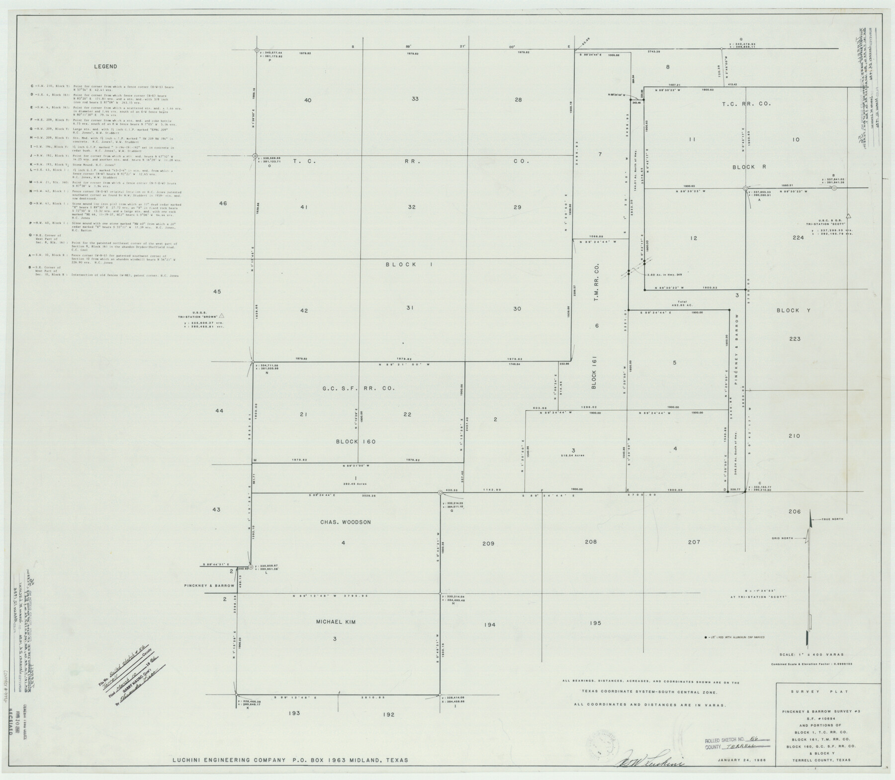
Terrell County Rolled Sketch 56
Survey plat - Pinckney & Barrow survey #3, SF-10694 and portions of Block 1, T. C. R.R. Co., Block 161, T. M. R.R. Co., Block 160, G. C. S. F. R.R. Co., & Block Y
-
Map/Doc
9992
-
Collection
General Map Collection
-
Object Dates
1986/1/24 (Creation Date)
1986/3/10 (File Date)
-
People and Organizations
Joseph W. Luchini (Surveyor/Engineer)
-
Counties
Terrell
-
Subjects
Surveying Rolled Sketch
-
Height x Width
36.6 x 42.0 inches
93.0 x 106.7 cm
-
Medium
mylar, print
-
Scale
1" = 400 varas
Part of: General Map Collection
Wilson County Sketch File 1

Print $6.00
- Digital $50.00
Wilson County Sketch File 1
1858
Size 10.4 x 7.5 inches
Map/Doc 40396
Nueces County Sketch File 42

Print $24.00
- Digital $50.00
Nueces County Sketch File 42
1950
Size 11.0 x 8.6 inches
Map/Doc 32633
Kaufman County Working Sketch 2

Print $20.00
- Digital $50.00
Kaufman County Working Sketch 2
1922
Size 19.7 x 16.5 inches
Map/Doc 66665
Nueces County Sketch File 52

Print $10.00
- Digital $50.00
Nueces County Sketch File 52
1947
Size 14.1 x 8.6 inches
Map/Doc 32858
Pecos County Rolled Sketch 142

Print $20.00
- Digital $50.00
Pecos County Rolled Sketch 142
Size 26.9 x 41.9 inches
Map/Doc 7276
Travis County Working Sketch 65

Print $20.00
- Digital $50.00
Travis County Working Sketch 65
2003
Size 28.1 x 38.3 inches
Map/Doc 78494
Polk County Sketch File 14a

Print $4.00
- Digital $50.00
Polk County Sketch File 14a
1863
Size 9.0 x 14.6 inches
Map/Doc 34155
Jefferson County Sketch File 5

Print $50.00
- Digital $50.00
Jefferson County Sketch File 5
1859
Size 7.9 x 6.9 inches
Map/Doc 28103
Flight Mission No. CUG-3P, Frame 19, Kleberg County

Print $20.00
- Digital $50.00
Flight Mission No. CUG-3P, Frame 19, Kleberg County
1956
Size 18.7 x 22.3 inches
Map/Doc 86229
Pecos County Sketch File 44

Print $8.00
- Digital $50.00
Pecos County Sketch File 44
Size 13.0 x 10.4 inches
Map/Doc 33743
Brazoria County Sketch File 25

Print $8.00
- Digital $50.00
Brazoria County Sketch File 25
1875
Size 8.4 x 13.2 inches
Map/Doc 15024
Houston County Working Sketch 1

Print $20.00
- Digital $50.00
Houston County Working Sketch 1
Size 20.6 x 15.6 inches
Map/Doc 66231
You may also like
Aransas County NRC Article 33.136 Location Key Sheet

Print $20.00
- Digital $50.00
Aransas County NRC Article 33.136 Location Key Sheet
1979
Size 27.0 x 23.0 inches
Map/Doc 77006
Panola County Sketch File 22

Print $40.00
- Digital $50.00
Panola County Sketch File 22
Size 15.1 x 16.0 inches
Map/Doc 33492
Lynn County Boundary File 12

Print $60.00
- Digital $50.00
Lynn County Boundary File 12
Size 14.0 x 17.5 inches
Map/Doc 56749
Flight Mission No. DAH-9M, Frame 199, Orange County

Print $20.00
- Digital $50.00
Flight Mission No. DAH-9M, Frame 199, Orange County
1953
Size 18.6 x 22.5 inches
Map/Doc 86867
Ector County Working Sketch 19

Print $40.00
- Digital $50.00
Ector County Working Sketch 19
1958
Size 65.8 x 37.6 inches
Map/Doc 68862
Flight Mission No. BRA-7M, Frame 13, Jefferson County

Print $20.00
- Digital $50.00
Flight Mission No. BRA-7M, Frame 13, Jefferson County
1953
Size 18.6 x 22.4 inches
Map/Doc 85464
[Surveys in Austin's Colony along the west bank of the Colorado River]
![199, [Surveys in Austin's Colony along the west bank of the Colorado River], General Map Collection](https://historictexasmaps.com/wmedia_w700/maps/199.tif.jpg)
Print $20.00
- Digital $50.00
[Surveys in Austin's Colony along the west bank of the Colorado River]
1831
Size 10.9 x 28.5 inches
Map/Doc 199
Val Verde County Sketch File Z0

Print $32.00
- Digital $50.00
Val Verde County Sketch File Z0
1881
Size 28.1 x 10.1 inches
Map/Doc 12550
Calhoun County NRC Article 33.136 Sketch 15

Print $46.00
Calhoun County NRC Article 33.136 Sketch 15
2025
Map/Doc 97428
Young County Rolled Sketch 12

Print $20.00
- Digital $50.00
Young County Rolled Sketch 12
Size 24.2 x 17.9 inches
Map/Doc 8300
Polk County Working Sketch 17

Print $20.00
- Digital $50.00
Polk County Working Sketch 17
1948
Size 28.3 x 18.5 inches
Map/Doc 71632
