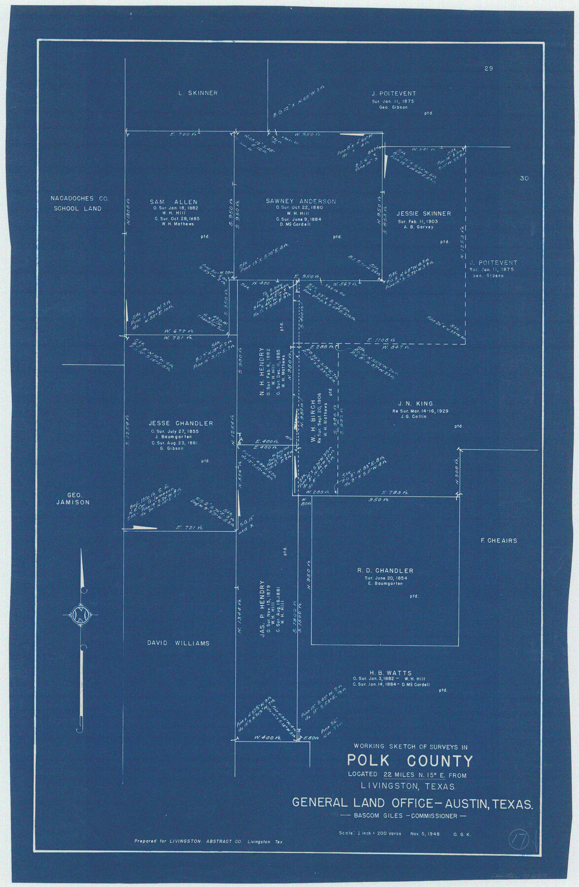
Polk County Working Sketch 17
-
Map/Doc
71632
-
Collection
General Map Collection
-
Object Dates
11/5/1948 (Creation Date)
-
People and Organizations
Otto G. Kurio (Draftsman)
-
Counties
Polk
-
Subjects
Surveying Working Sketch
-
Height x Width
28.3 x 18.5 inches
71.9 x 47.0 cm
-
Scale
1" = 200 varas
Part of: General Map Collection
[Surveys in the Travis District along Onion Creek and the Pedernales River]
![40, [Surveys in the Travis District along Onion Creek and the Pedernales River], General Map Collection](https://historictexasmaps.com/wmedia_w700/maps/40.tif.jpg)
Print $20.00
- Digital $50.00
[Surveys in the Travis District along Onion Creek and the Pedernales River]
1841
Size 14.0 x 15.8 inches
Map/Doc 40
Montgomery County Rolled Sketch 42

Print $20.00
- Digital $50.00
Montgomery County Rolled Sketch 42
1939
Size 14.1 x 20.3 inches
Map/Doc 6815
Medina County Sketch File 16

Print $8.00
- Digital $50.00
Medina County Sketch File 16
1948
Size 11.4 x 8.8 inches
Map/Doc 31476
Hutchinson County Working Sketch 22

Print $40.00
- Digital $50.00
Hutchinson County Working Sketch 22
1966
Size 67.9 x 35.5 inches
Map/Doc 66382
Right of Way and Track Map, the Missouri, Kansas and Texas Ry. of Texas - Henrietta Division

Print $20.00
- Digital $50.00
Right of Way and Track Map, the Missouri, Kansas and Texas Ry. of Texas - Henrietta Division
1918
Size 11.8 x 26.8 inches
Map/Doc 64751
Presidio County Rolled Sketch T-1

Print $20.00
- Digital $50.00
Presidio County Rolled Sketch T-1
Size 26.8 x 27.1 inches
Map/Doc 7416
Marion County Working Sketch 35

Print $20.00
- Digital $50.00
Marion County Working Sketch 35
1985
Size 27.3 x 28.2 inches
Map/Doc 70811
Reagan County Boundary File 2

Print $20.00
- Digital $50.00
Reagan County Boundary File 2
Size 17.5 x 32.4 inches
Map/Doc 58190
[Right of Way Map, Belton Branch of the M.K.&T. RR.]
![64224, [Right of Way Map, Belton Branch of the M.K.&T. RR.], General Map Collection](https://historictexasmaps.com/wmedia_w700/maps/64224.tif.jpg)
Print $20.00
- Digital $50.00
[Right of Way Map, Belton Branch of the M.K.&T. RR.]
1896
Size 7.1 x 20.6 inches
Map/Doc 64224
Coleman County Sketch File 45

Print $20.00
- Digital $50.00
Coleman County Sketch File 45
1897
Size 23.9 x 23.8 inches
Map/Doc 11124
Briscoe County Rolled Sketch 14B

Print $20.00
- Digital $50.00
Briscoe County Rolled Sketch 14B
1929
Size 32.6 x 37.3 inches
Map/Doc 8531
Flight Mission No. DQO-3K, Frame 17, Galveston County

Print $20.00
- Digital $50.00
Flight Mission No. DQO-3K, Frame 17, Galveston County
1952
Size 18.9 x 22.5 inches
Map/Doc 85058
You may also like
Limestone County Sketch File 27

Print $20.00
- Digital $50.00
Limestone County Sketch File 27
Size 23.2 x 18.8 inches
Map/Doc 12004
Bee County Working Sketch 31

Print $20.00
- Digital $50.00
Bee County Working Sketch 31
1929
Size 13.5 x 25.1 inches
Map/Doc 67282
Limestone County Boundary File 59

Print $34.00
- Digital $50.00
Limestone County Boundary File 59
Size 7.4 x 8.7 inches
Map/Doc 56299
Parker County Sketch File 37

Print $4.00
- Digital $50.00
Parker County Sketch File 37
Size 4.8 x 8.1 inches
Map/Doc 33581
Hill County Boundary File 45a

Print $54.00
- Digital $50.00
Hill County Boundary File 45a
Size 14.4 x 9.0 inches
Map/Doc 54763
Andrews County Working Sketch 16

Print $20.00
- Digital $50.00
Andrews County Working Sketch 16
1957
Size 36.3 x 44.6 inches
Map/Doc 67062
Travis County Working Sketch 61

Print $20.00
- Digital $50.00
Travis County Working Sketch 61
1995
Size 20.9 x 24.7 inches
Map/Doc 69445
Kerr County Boundary File 4a

Print $16.00
- Digital $50.00
Kerr County Boundary File 4a
Size 6.1 x 8.2 inches
Map/Doc 64801
Nolan County Sketch File 1

Print $48.00
- Digital $50.00
Nolan County Sketch File 1
1890
Size 14.1 x 8.5 inches
Map/Doc 32470
Brazoria County Rolled Sketch 46

Print $40.00
- Digital $50.00
Brazoria County Rolled Sketch 46
1950
Size 30.7 x 57.3 inches
Map/Doc 8462
Frio County Sketch File 18

Print $8.00
- Digital $50.00
Frio County Sketch File 18
1961
Size 14.3 x 8.9 inches
Map/Doc 23155
Jasper County Working Sketch 15

Print $20.00
- Digital $50.00
Jasper County Working Sketch 15
1925
Size 26.8 x 22.1 inches
Map/Doc 66477