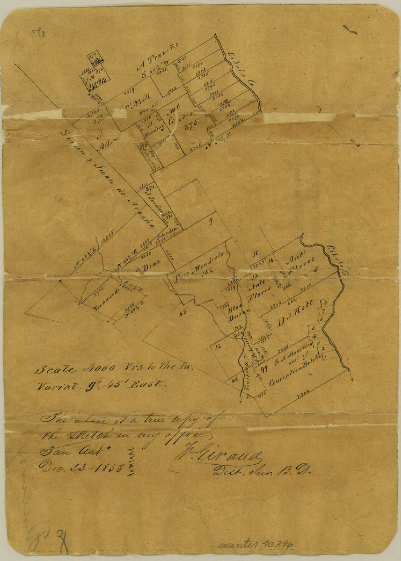
Wilson County Sketch File 1
[Sketch south of Sutherland Springs]
-
Map/Doc
40396
-
Collection
General Map Collection
-
Object Dates
12/23/1858 (Creation Date)
12/28/1858 (File Date)
-
People and Organizations
F. Giraud (Surveyor/Engineer)
-
Counties
Wilson
-
Subjects
Surveying Sketch File
-
Height x Width
10.4 x 7.5 inches
26.4 x 19.1 cm
-
Medium
paper, manuscript
-
Scale
1" = 4000 varas
-
Features
Cibolo Creek
Sutherland Springs
Part of: General Map Collection
Kinney County Sketch File 40

Print $6.00
Kinney County Sketch File 40
Size 14.0 x 8.5 inches
Map/Doc 97247
Tarrant County Sketch File 14

Print $7.00
- Digital $50.00
Tarrant County Sketch File 14
1859
Size 10.2 x 8.4 inches
Map/Doc 37705
Sabine River, North Extension Merrill Lake Sheet

Print $20.00
- Digital $50.00
Sabine River, North Extension Merrill Lake Sheet
1933
Size 23.2 x 42.6 inches
Map/Doc 65140
Flight Mission No. DAG-14K, Frame 143, Matagorda County

Print $20.00
- Digital $50.00
Flight Mission No. DAG-14K, Frame 143, Matagorda County
1952
Size 16.4 x 16.4 inches
Map/Doc 86310
Hudspeth County Rolled Sketch 64

Print $40.00
- Digital $50.00
Hudspeth County Rolled Sketch 64
1986
Size 39.1 x 81.9 inches
Map/Doc 9228
San Jacinto County Sketch File 6

Print $4.00
San Jacinto County Sketch File 6
1847
Size 12.7 x 8.2 inches
Map/Doc 35703

El Paso County Rolled Sketch Z51

Print $40.00
- Digital $50.00
El Paso County Rolled Sketch Z51
1915
Size 37.2 x 49.0 inches
Map/Doc 8868
Bell County Working Sketch 10

Print $20.00
- Digital $50.00
Bell County Working Sketch 10
1954
Size 38.2 x 41.4 inches
Map/Doc 67350
Tyler County Sketch File 6a

Print $4.00
- Digital $50.00
Tyler County Sketch File 6a
Size 10.1 x 8.0 inches
Map/Doc 38635
El Paso County Rolled Sketch 66

Print $20.00
- Digital $50.00
El Paso County Rolled Sketch 66
2014
Size 35.1 x 41.2 inches
Map/Doc 93712
Johnson County Working Sketch 32

Print $20.00
- Digital $50.00
Johnson County Working Sketch 32
2008
Size 29.2 x 27.4 inches
Map/Doc 88817
You may also like
Williamson County Sketch File 29

Print $18.00
- Digital $50.00
Williamson County Sketch File 29
Size 10.2 x 8.2 inches
Map/Doc 40377
[F. W. & D. C. Ry. Co. Alignment and Right of Way Map, Clay County]
![64745, [F. W. & D. C. Ry. Co. Alignment and Right of Way Map, Clay County], General Map Collection](https://historictexasmaps.com/wmedia_w700/maps/64745-GC.tif.jpg)
Print $20.00
- Digital $50.00
[F. W. & D. C. Ry. Co. Alignment and Right of Way Map, Clay County]
1927
Size 18.7 x 11.8 inches
Map/Doc 64745
Flight Mission No. DIX-10P, Frame 178, Aransas County

Print $20.00
- Digital $50.00
Flight Mission No. DIX-10P, Frame 178, Aransas County
1956
Size 18.5 x 22.2 inches
Map/Doc 83968
Presidio County Working Sketch 13

Print $20.00
- Digital $50.00
Presidio County Working Sketch 13
1941
Size 25.7 x 41.5 inches
Map/Doc 71689
Conway, Carson County, Texas

Print $20.00
- Digital $50.00
Conway, Carson County, Texas
Size 17.2 x 22.3 inches
Map/Doc 90227
Dimmit County Working Sketch 29

Print $40.00
- Digital $50.00
Dimmit County Working Sketch 29
1957
Size 58.1 x 36.2 inches
Map/Doc 68690
Val Verde County Working Sketch 21

Print $20.00
- Digital $50.00
Val Verde County Working Sketch 21
1929
Size 15.2 x 30.0 inches
Map/Doc 72156
Crockett County Working Sketch 35

Print $20.00
- Digital $50.00
Crockett County Working Sketch 35
1927
Size 20.2 x 25.5 inches
Map/Doc 68368
Chambers County Aerial Photograph Index Sheet 4

Print $20.00
- Digital $50.00
Chambers County Aerial Photograph Index Sheet 4
1956
Size 19.7 x 15.6 inches
Map/Doc 83685
Morris County Boundary File 3

Print $6.00
- Digital $50.00
Morris County Boundary File 3
Size 10.8 x 8.1 inches
Map/Doc 57485
Presidio County Working Sketch 83

Print $20.00
- Digital $50.00
Presidio County Working Sketch 83
1969
Size 21.5 x 24.8 inches
Map/Doc 71760
Flight Mission No. CUI-1H, Frame 97, Milam County

Print $20.00
- Digital $50.00
Flight Mission No. CUI-1H, Frame 97, Milam County
1951
Size 18.5 x 22.2 inches
Map/Doc 86605