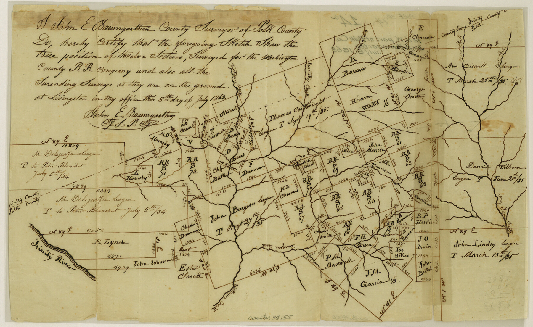
Polk County Sketch File 14a
[Sketch in northwest part of county]
-
Map/Doc
34155
-
Collection
General Map Collection
-
Object Dates
7/8/1863 (Creation Date)
-
People and Organizations
John E. Baumgarten (Surveyor/Engineer)
-
Counties
Polk Trinity
-
Subjects
Surveying Sketch File
-
Height x Width
9.0 x 14.6 inches
22.9 x 37.1 cm
-
Medium
paper, manuscript
-
Features
Kickapoo Creek
Rockky [sic] Creek
Bear Blanch Creek
Long Tom Creek
West Fork of Long Tom Creek
East Fork of Long Tom Creek
Tomerson Creek
Trinity River
Burger's Creek
Part of: General Map Collection
Galveston County Working Sketch 3

Print $20.00
- Digital $50.00
Galveston County Working Sketch 3
1915
Size 21.4 x 19.5 inches
Map/Doc 69340
Atascosa County Rolled Sketch 20

Print $20.00
- Digital $50.00
Atascosa County Rolled Sketch 20
1956
Size 36.0 x 44.0 inches
Map/Doc 8432
Padre Island, Register No. 1485a

Print $40.00
- Digital $50.00
Padre Island, Register No. 1485a
1881
Size 55.7 x 36.7 inches
Map/Doc 73609
Presidio County Working Sketch 125

Print $20.00
- Digital $50.00
Presidio County Working Sketch 125
1985
Size 32.7 x 27.9 inches
Map/Doc 71803
Hardin County Sketch File 9a

Print $4.00
- Digital $50.00
Hardin County Sketch File 9a
1860
Size 9.9 x 8.4 inches
Map/Doc 25108
Flight Mission No. DQN-7K, Frame 91, Calhoun County

Print $20.00
- Digital $50.00
Flight Mission No. DQN-7K, Frame 91, Calhoun County
1953
Size 18.4 x 22.2 inches
Map/Doc 84482

Orange County Rolled Sketch 16

Print $20.00
- Digital $50.00
Orange County Rolled Sketch 16
Size 42.2 x 30.4 inches
Map/Doc 41813
Colorado County Working Sketch Graphic Index

Print $40.00
- Digital $50.00
Colorado County Working Sketch Graphic Index
1946
Size 52.7 x 42.4 inches
Map/Doc 76500
Winkler County Sketch File 5

Print $16.00
- Digital $50.00
Winkler County Sketch File 5
1900
Size 11.2 x 8.7 inches
Map/Doc 40467
Palo Pinto County Boundary File 4b

Print $38.00
- Digital $50.00
Palo Pinto County Boundary File 4b
Size 13.6 x 8.6 inches
Map/Doc 57824
Young County Sketch File 10c

Print $4.00
- Digital $50.00
Young County Sketch File 10c
1878
Size 8.2 x 15.4 inches
Map/Doc 40872
You may also like
Nueces County Sketch File 21

Print $8.00
- Digital $50.00
Nueces County Sketch File 21
1880
Size 5.9 x 5.5 inches
Map/Doc 32557
Guadalupe County Rolled Sketch 1

Print $20.00
- Digital $50.00
Guadalupe County Rolled Sketch 1
1954
Size 33.1 x 38.8 inches
Map/Doc 6044
Brewster County Working Sketch 60

Print $20.00
- Digital $50.00
Brewster County Working Sketch 60
1955
Size 22.3 x 18.2 inches
Map/Doc 67661
The Republic County of Colorado. 1841

Print $20.00
The Republic County of Colorado. 1841
2020
Size 18.4 x 21.7 inches
Map/Doc 96123
Showing Position of Original and Re-Survey Corners in Lynn, Terry, Yoakum, Gaines and Dawson Counties, Texas

Print $40.00
- Digital $50.00
Showing Position of Original and Re-Survey Corners in Lynn, Terry, Yoakum, Gaines and Dawson Counties, Texas
1946
Size 57.3 x 22.1 inches
Map/Doc 93044
Mills County Boundary File 8

Print $10.00
- Digital $50.00
Mills County Boundary File 8
Size 14.2 x 8.7 inches
Map/Doc 57313
[Sketch showing Leagues 464, 467-472, 483-489, 495, 510, 517, 532, 541, 556-570]
![89802, [Sketch showing Leagues 464, 467-472, 483-489, 495, 510, 517, 532, 541, 556-570], Twichell Survey Records](https://historictexasmaps.com/wmedia_w700/maps/89802-1.tif.jpg)
Print $20.00
- Digital $50.00
[Sketch showing Leagues 464, 467-472, 483-489, 495, 510, 517, 532, 541, 556-570]
Size 44.8 x 42.7 inches
Map/Doc 89802
San Saba County Sketch File 11

Print $8.00
- Digital $50.00
San Saba County Sketch File 11
1882
Size 12.4 x 8.3 inches
Map/Doc 36435
Gregg County Sketch File 8

Print $28.00
- Digital $50.00
Gregg County Sketch File 8
1931
Size 12.9 x 8.3 inches
Map/Doc 24582
McMullen County Working Sketch 7

Print $20.00
- Digital $50.00
McMullen County Working Sketch 7
1926
Size 20.7 x 17.5 inches
Map/Doc 70708
Etats-Unis de l'Amérique Septentrionale avec les Isles Royale, de Terre Neuve de St. Jean, L'Acadie &c.

Print $20.00
- Digital $50.00
Etats-Unis de l'Amérique Septentrionale avec les Isles Royale, de Terre Neuve de St. Jean, L'Acadie &c.
1785
Size 20.9 x 28.2 inches
Map/Doc 93679
Bell County Sketch File 34

Print $40.00
- Digital $50.00
Bell County Sketch File 34
Size 15.4 x 13.4 inches
Map/Doc 14455